
Hungerburgbahn (1906-2005)
| Hungerburgbahn | |||||||||||||||||||||||||
|---|---|---|---|---|---|---|---|---|---|---|---|---|---|---|---|---|---|---|---|---|---|---|---|---|---|
| Route length: | 0.839 km | ||||||||||||||||||||||||
| Gauge : | 1000 mm ( meter gauge ) | ||||||||||||||||||||||||
|
|||||||||||||||||||||||||


The Hungerburgbahn was a mountain railway in Innsbruck that led from the rotunda in the Saggen district - in which the giant circular painting was kept until 2010 - to the Hungerburg . She conquered 286 meters in altitude. The railway was shut down in 2005, a year before its 100th anniversary, in favor of the construction of the new Hungerburg Railway, which had been partially re-routed and was one kilometer longer .
history
The first Hungerburg Railway was planned by engineer Josef Riehl and ran from September 12, 1906 to December 8, 2005.
It led from the rotunda ( 572 m above sea level ) in the Saggen district , which until 2010 housed the Innsbruck giant circular painting , up to the Hungerburg ( 858 m above sea level ).
The listed stamped concrete viaduct below the mountain station is 160 meters long and has an average height of 12 meters. It leads over 15 arches with a clear width of 6 meters. From the valley station, a steel construction and also a listed bridge leads over the Inn . On July 31, 1987, a stop for the nearby alpine zoo was opened, but it was a little below the middle of the route (siding). When operating this stop, the higher car had to wait in the open.
The Hungerburgbahn, together with the Nordkettenbahn, opened up the Nordkette ( Seegrube and the Hafelekar ) and served in part as public transport from the higher residential areas of the Hungerburg to the center. The Hungerburg is a district that was founded by Sebastian Kandler as a tourist center at the turn of the century. In December 2005, the almost 100-year-old railway was discontinued in favor of the new Hungerburgbahn .
Technical specifications
The height difference of the Hungerburgbahn was 287 m, the route length 839 m. It had a track width of 1 m and rails according to the Stanserhorn wedge head format. The greatest incline was 48.7%, up to 92 people could be transported per cabin at a speed of 4 m / s or 2.5 m / s. With the original AC motor from 1906, the journey time was 11 minutes and 300 people could be transported per hour. In 1957/58 the railway was completely overhauled, the longitudinal profile in the upper part of the line corrected and the old drive replaced by a new 190 kW drive.
Current condition
To date, the base station of the old Hungerburgbahn is still preserved, as well as the listed Innbrücke or the listed stamped concrete - Viaduct before the mountain station. The cultural center and the "Talstation" event location are now located in the valley station. In addition to office and seminar rooms for young Innsbruck clubs and initiatives, it also offers a bar, a band room and a photo laboratory. The former departure hall has been converted into a 250-person event hall. B. can be used in many ways for theater, concerts, discussions or film lectures. Most of the track systems have now been dismantled and the former line has largely grown over, but is still very clearly visible.
photos

The Inn Bridge (1994)

Bridge over Richardsweg (1994)
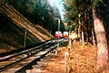
The turnout of the old Hungerburgbahn (1994)

The valley station after the closure (2008)

One of the wagons of the Hungerburgbahn in Jenbach (exhibited on the platform of the Achenseebahn after the shutdown (2006))


literature
- The new mountain railway from Innsbruck to the Hungerburg. Here are two pictures based on photographs by K. Dornach. In: Der Naturfreund , year 1906, X. year, p. 174 f. (Online at ANNO ). .
- Roland Kubanda (Ed.): City escape 10m / sec. Innsbruck and the Nordkettenbahn. Contributions to the 75th anniversary . Publications of the Innsbruck City Archives, New Series Volume 29, ZDB -ID 2443323-8 . Studies Verlag, Innsbruck 2003, ISBN 3-7065-1890-2 . (This also includes technical contributions to the Hungerburgbahn and Nordkettenbahn by Günter Denoth).
- Karl Armbruster: The Tyrolean mountain railways . Buchdruckerei G. Davis & Co., Vienna 1914, Die Hungerburgbahn, p. 95–105 ( digitized version from the South Tyrolean Regional Library [accessed on September 15, 2017]).
Web links
- Historical photos ( Memento from December 12, 2003 in the Internet Archive )
Individual evidence
- ↑ Trade, Industry, Transport and Agriculture. (...) rail transport. In: Wiener Zeitung , November 14, 1906, p. 9, bottom right. (Online at ANNO ).
Coordinates: 47 ° 17 '0.3 " N , 11 ° 24' 8.7" E
Railways (standard gauge), in operation: Kufstein – Innsbruck | Innsbruck – Verona | Innsbruck – Bludenz | Innsbruck – Garmisch-Partenkirchen | Garmisch-Partenkirchen – Reutte – Kempten | Innsbruck bypass | not carried out: Landeck – Mals | under construction / planning: Grafing – Innsbruck (HLS) | Brenner base tunnel
Railways (narrow gauge), in operation: Innsbruck – Fulpmes | Innsbruck – Igls (today part of the Innsbruck tram) | Jenbach – Mayrhofen (Zillertal Railway) | Kiefersfelden – Wachtl | set: Kufstein – Schwoich
Trams, in operation: Innsbruck tram | (Narrow gauge), discontinued: Innsbruck – Hall iT
Cogwheel and funicular railways: Jenbach – Seespitz | Hungerburgbahn | Old Hungerburgbahn | Kaiser Maximilian Panorama Railway | Olympic track