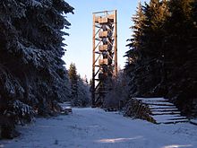
Idarkopf tower
The Idarkopf Tower in Hunsrück part Idarwald in Rheinland-Pfalz is a 28 m (according to other sources 28.50 m) high observation tower on the Idarkopf ( 745.7 m above sea level. NHN ). Since a fire on October 21, 2018, the tower has been closed due to the risk of collapse.
Geographical location
The Idarkopf tower is located in the Saar-Hunsrück Nature Park about 200 m northwest of the Idarkopf summit, which rises between the southeastern Stipshausen ( district of Birkenfeld ) and northwestern Hochscheid ( district of Bernkastel-Wittlich ). Its location is at an altitude of 744.2 m . A transmission tower stands around 320 m northeast of the observation tower at a height of around 738 m .
History and description
The Idarkopf Tower was built as a wooden structure in 1980 and replaced the dilapidated over time become precursor tower than 1,909 artillery had been erected observation stood on a wooden ladder to be climbed needed. The tower, which is very similar to the Atzelberg Tower near Kelkheim (Taunus), has a triangular floor plan with an edge length of 7.3 m and has 150 steps that lead over 12 intermediate landings to the 26.50 m high viewing platform . The six intermediate landings above the access side protrude 1 m from the tower.
On October 21, 2018, the Idarkopf tower was severely damaged by arson.
Opportunity to view and use
Today the Idarkopf tower is especially used for viewing. From its viewing platform, the view falls down to Stipshausen and Hochscheid and for example to the Großer Feldberg ( 881.5 m ) in the Taunus , to the Donnersberg ( 668.5 m ) in the North Palatinate Bergland , over the landscape of the Hunsrück with the Erbeskopf ( 816 , 32 m ), to the Hohe Acht ( 746.9 m ) in the Eifel and to the Fuchskaute ( 657.3 m ) in the Westerwald .
The tower also serves as a platform for the activities of radio amateurs participating in Summits on the Air Germany .
Web links
Individual evidence
- ↑ a b Photo of the information board at the Idarkopf tower, on commons.wikimedia.org.
- ↑ a b c d observation towers on the Hunsrück , on hunsrueck-zeitung.com.
- ↑ a b Arson suspected - lookout tower on Idarkopf closed after fire. Südwestrundfunk , October 22, 2018, accessed on October 22, 2018 .
- ↑ Map service of the landscape information system of the Rhineland-Palatinate nature conservation administration (LANIS map) ( notes )
- ↑ Panoramic view from the tower (labeling of visual targets can be activated), on panorama-photo.net.
Coordinates: 49 ° 51 ′ 41.9 ″ N , 7 ° 16 ′ 13.4 ″ E
