Atzelberg
| Atzelberg | ||
|---|---|---|
|
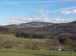
Atzelberg with telecommunications tower |
||
| height | 506.7 m above sea level NHN | |
| location | near Eppenhain and Ruppertshain ; Main-Taunus-Kreis , Hessen ( Germany ) | |
| Mountains | Taunus | |
| Dominance | 1.5 km → Rossert | |
| Notch height | 52 m ↓ Eppenhain | |
| Coordinates | 50 ° 10 '28 " N , 8 ° 23' 18" E | |
|
|
||
| particularities | - Telecommunication tower - Atzelbergturm ( AT ) |
|
The Atzelberg is 506.7 m above sea level. NHN high mountain in the Taunus . It is located near Eppenhain and Ruppertshain in the Hessian Main-Taunus district .
On the Atzelberg there is a telecommunications tower and the Atzelbergturm observation tower with a barbecue area and barbecue hut, as well as a football field . The mountain is a popular destination for hikers and cyclists. The mountain name is derived from a dialect name for the Elster .
geography
location
The Atzelberg is located in the Taunus Nature Park . Its summit is north of Eppenhain and west of Ruppertshain , two districts of Kelkheim that reach up to the high elevations of the mountain . The Fischbach flows north past the mountain , on its east-southeast flank the Fischbach (Krebsbach) rises on the outskirts of Ruppertshain . The south-eastern neighbor is the Rossert ( 515.9 m ).
Natural allocation

The Atzelberg belongs to the natural spatial main unit group Taunus (No. 30) and in the main unit Hoher Taunus (301) to the subunit Feldberg-Taunuskamm (301.3). The landscape leads south into the sub-unit Eppstein-Hornauer Vortaunus (300.1) and to the south-east into the natural area Königsteiner Taunusfuß (300.20) belonging to the sub-unit Altkönig Vorstufe (300.2 ), both of which are part of the main unit Vortaunus (300).
Telecommunications tower
The telecommunications tower ( type tower ) erected in 1969 is 98 m high and made of reinforced concrete . As of 2008, it is only used for mobile communications . The tower can be reached from Eppenhain via a paved path that is closed to motor vehicles.
Atzelberg Tower
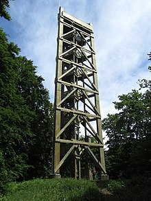
The Atzelbergturm was a 30.39 m high observation tower made of pine wood, the open viewing platform at around 533 m above sea level. NHN could be reached over 151 steps. This made it the highest publicly accessible point in the Main-Taunus district.
It was the third observation tower on the Atzelberg. From 1913 to 1976, there were at the same place already a steel truss tower that after the wife of the founder of the factory director Philipp Maul , Luisenturm said. The old tower had to be demolished because it was in disrepair; the city of Kelkheim promised a new building after Eppenhain was incorporated in 1977. The successor, built in 1980, like the third tower, was also a 30.39 m high timber frame construction with a triangular floor plan. It had 169 steps and probably burned down by arson on the morning of August 5, 2008 . The ruins of the tower were then torn down.
After plans by a network provider to rebuild the tower at its own expense and to install a cellular antenna there failed due to resistance from the population, the city of Kelkheim was initially unable to finance the planned rebuilding. Not least because of a private donation of 80,000 euros, the Atzelbergturm was then rebuilt from wood in 2012 for a total of 330,000 euros and inaugurated on October 27 of the same year. On the night of July 3, 2017, a fire broke out on this tower in the upper third, which damaged it considerably, so that the tower is currently no longer accessible. It was not until the summer of 2019 that it became public that this tower would also be demolished (which has now happened) and that it would be rebuilt as a steel structure in its place.
60 meters east of the observation tower is a barbecue area with a barbecue hut and about 250 meters east-southeast of it is a football field .
The tower offers a largely unobstructed view in all directions. Among other things, the densely built-up Rhine-Main region with the skyline of Frankfurt am Main can be seen in the south-east and the wooded and hilly Hintertaunus in the north-east .
gallery
Atzelberg from the north; in front of it the Neumühle on Landstrasse 3016 and in the foreground the path to the Silberbachtal nature reserve near Schloßborn
See also
literature
- Hermin Herr: Lexicon from the High Taunus. 1993, ISBN 3-7829-0437-0 , p. 10.
Individual evidence
- ↑ a b Map services of the Federal Agency for Nature Conservation ( information )
- ↑ Brigitte Schwenzer: Geographical land survey: The natural spatial units on sheet 139 Frankfurt am Main. Federal Institute for Regional Studies, Bad Godesberg 1967. → Online map (PDF; 4.9 MB)
- ↑ a b Photo of the information board at the new Atzelbergturm, on commons.wikimedia.org
- ↑ Photo of the information board on the burned down Atzelberg tower, on commons.wikimedia.org
- ↑ Atzelbergturm burned down ( memento from February 11, 2013 in the web archive archive.today ), on fr-online, from August 5, 2008, accessed on November 15, 2012
- ↑ Voilà: This is the new Atzelberg Tower ( Memento from February 10, 2013 in the web archive archive.today ), FNP from June 29, 2012, accessed on July 13, 2012
- ↑ The new Atzelberg Tower , fr-online, October 29, 2012, accessed on November 15, 2012
- ↑ Atzelberg tower in the Taunus region again damaged by fire ( memento from May 29, 2018 in the Internet Archive ), from July 3, 2017, accessed on July 3, 2017, on fnp.de.
- ^ Message in the Hessischer Rundfunk on the morning of July 8, 2019
Web links
- Panoramic view from the Atzelberg Tower , on frankfurt360.de


