
Independence Avenue (Windhoek)
| Independence Avenue | |
|---|---|
|
|
|
 |
|
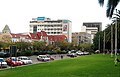
| Independence Avenue in Windhoek-Central | |
| Basic data | |
| place | Windhoek |
| Created | circa 1890 |
| Newly designed | 1956 |
| Hist. Names | Kaiserstrasse |
| Name received | 1990 |
| Connecting roads | Rehobother Weg, Jan Jonker Weg, Eveline St |
| Cross streets | various |
| Places | Dr. Antonio Agostinho Neto Square , Sam Nujoma Circle |
| Numbering system | Orientation numbering |
| use | |
| User groups | Pedestrian traffic , bicycle traffic , car traffic , public transport |
| Technical specifications | |
| Street length | 10 km |
The Independence Avenue (to German "Independence Avenue" ) is a main transport and major shopping street in the Namibian capital Windhoek . It stretches for about 10 kilometers.
history

Independence Avenue was the city's most important artery when Windhoek was founded in 1890 by Curt von François . In 1956 the street in the area of the Zoo Park was widened.
Until Namibia's independence, it was called “Kaiserstraße”, originally “Kaiser-Wilhelm-Straße”.
Location and expansion
Independence Avenue begins in the center of Windhoek at Dr. Antonio Agostinho Neto Square (Ausspannplatz; Windhoek- Central ) and extends, with two - partially separated - lanes for each direction, to the north of the city parts Windhoek- Nord , Windhoek- Katutura and Windhoek- Samora Machel Constituency until the northwest of the town in the Goreangab Dam ends. It is completely attached with a bitumen cover . Independence Avenue can be roughly divided into three areas based on their development and use.
Downtown area
The downtown area to the south begins at Dr. Antonio Agostinho Neto Square and includes Windhoek-Central and the southern part of Windhoek-Nord with shops, ministries, hotels, historical buildings from the German colonial era and office buildings. Here are numerous sights such as the historically significant Zoo Park and the Erkrath-Gathemann-Kronprinz building complex .
Numerous Namibian ministries and government institutions , embassies, such as the German embassy in the Sanlam Center , and airlines are based in this area of Independence Avenue .
Opposite the “Gustav Voigts Center”, the country's largest construction project worth two billion Namibian dollars has been completed since 2009. In the first construction phase, the Hotel Hilton Windhoek opened in mid-2011. In a second construction phase, which is to be followed by others, the residential and commercial building "1990" will be built. The entire square is called "Eliakim Namundjebo Plaza", but is also known as "Freedom Plaza".
Buildings
Significant structures and buildings in this area of Independence Avenue are - from south to north - among others:
- City of Windhoek
- Hilton Windhoek, at the southern end of "Eliakim Namundjebo Plaza"
- Gustav Voigts Center with the AVANI Windhoek Hotel and Wecke & Voigts
- Alexander Forbes house with the Carl List Mall
- Sanlam Center
- Mutual Tower
- Erkrath-Gatheman-Kronprinz building complex
- Zoo park
- Namdeb Center
- Frans Indongo Gardens
- Kudu Monument
- Imperial land survey
- Station area of Trans Namib
Views

Curt von François monument

Sanlam Center in Windhoek-Central

Wood carving market with the Sanlam Center in the background
From Independence Avenue in Windhoek Central Zoo Park taken from

Erkrath-Gatheman-Kronprinz building complex

War memorial in the zoo park
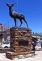
Kudu Monument


Middle area
The middle part of Indepence Avenue extends roughly from Etna Strasse in the south to Wilibald-Kapuenene-Strasse in the north. This area is dominated by green spaces and main roads such as the B1 national road . In addition to the TransNamib railway site on the west side, the main fire station and the Katutura State Hospital in the south of Windhoek-Katutura are located here .
Northern area
The entire northern area of Independence Avenue is mainly dominated by single houses and small residential buildings. About halfway up is the largest open market in town, the Soweto Market . Around the northern third of this area in the Wanaheda district is partially characterized by slum-like areas.
Special
Every year the big carnival parade and parades on the Namibian Independence Day take place on Independence Avenue .
Web links
- Official website of Windhoek with information on Independence Avenue (English)
- Online City Guide to Windhoek (English)
- City Guide Windhoek (English)
Individual evidence
- ↑ Google Earth Pro . Measured on October 18, 2019.
- ^ New Hilton hotel in the center of Namibia's capital . Press Notice, United Africa Group, May 31, 2011
- ↑ Freedom Plaza 1990 ( Memento of the original from May 5, 2013 in the Internet Archive ) Info: The archive link was inserted automatically and has not yet been checked. Please check the original and archive link according to the instructions and then remove this notice. , accessed August 11, 2011.
- ↑ Wecke & Voigts website (English)
Coordinates: 22 ° 33 ′ 20.7 ″ S , 17 ° 5 ′ 0.2 ″ E