Indravati
| Indravati | ||
|
Course of the Indravati as the left tributary of the Godavari |
||
| Data | ||
| location | Odisha , Maharashtra , Chhattisgarh (India) | |
| River system | Godavari | |
| Headwaters |
Dandakaranya chain ( Eastern Ghats ) 19 ° 26 ′ 46 ″ N , 83 ° 7 ′ 10 ″ E |
|
| Source height | approx. 914 m | |
| muzzle | in the Godavari coordinates: 18 ° 43 ′ 24 " N , 80 ° 15 ′ 46" E 18 ° 43 ′ 24 " N , 80 ° 15 ′ 46" E |
|
| Mouth height | 106 m | |
| Height difference | approx. 808 m | |
| Bottom slope | approx. 1.4 ‰ | |
| length | 585 km | |
| Catchment area | 40,625 km² | |
| Left tributaries | Nandiraj | |
| Right tributaries | Bhaskal, Narangi , Boarding, Nibra, Kotri, Bandia, Gudra , Pamulgatami , Parlkota | |
| Reservoirs flowed through | Indravati dam | |
| Medium-sized cities | Nabarangpur , Jagdalpur | |
| Small towns | Feces pad | |
|
Indravati near Jagdalpur (Chhattisgarh) |
||
The Indravati ( Odia : ଇନ୍ଦ୍ରାବତୀ ନଦୀ, Hindi : इंद्रावती नदी, Marathi : इन्द्रावती, Telugu : ఇంద్రావతి నది) is an approx. 585 km long left tributary of the Godavari , the second longest river in India .
course
The Indravati has its source in the Dandakaranya chain in the eastern Ghats in the Indian state of Odisha . On the upper reaches it is dammed by the Indravati dam . Much of the water is diverted to the Hati , a tributary of the Tel , for power generation and irrigation . Below the dam, the Indravati flows west past the cities of Nabarangpur , Kotpad and Jagdalpur to Chhattisgarh , where it flows through one of the most pristine and beautiful regions of the country in the Bastar district . At the confluence of the right tributaries Pamulgatami and Parlkota , it turns south and forms the border between the central Indian states of Maharashtra and Chhattisgarh for the last 125 km . After about 585 km it joins the Godavari from the north.
Attractions
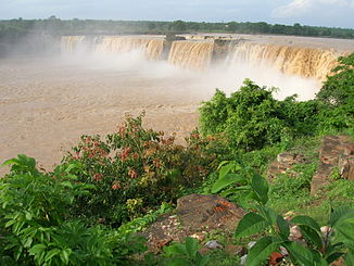
The Indravati is the lifeline of the Bastar district . To the west of Jagdalpur, the river forms the well-known Chitrakot waterfall , the widest waterfall in India. On the banks of the river in the Dantewara district is Indravati National Park , the most visited national park in Chhattisgarh.
Web links
Individual evidence
- ↑ Indravati - catchment area and length ( memento of the original from March 9, 2017 in the Internet Archive ) Info: The archive link was inserted automatically and has not yet been checked. Please check the original and archive link according to the instructions and then remove this notice.
- ↑ Indravati, headwaters - map with altitude information
- ↑ Indravati, mouth - map with elevation information


