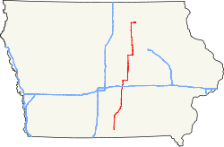
Iowa Highway 14

|
|
|---|---|
| map | |

|
|
| Basic data | |
| Overall length: | 187.84 mi (302.30 km) |
| Opening: | 1920 |
| Starting point: |
|
| End point: |
|
| Counties: |
Wayne Lucas Marion Jasper Marshall Grundy Butler Floyd |
| Important cities: | Corydon Knoxville Monroe Newton Marshalltown Grundy Center Parkersburg Allison Greene Charles City |
The Iowa Highway 14 is the US -amerikanischen State Iowa from south to north almost completely swept State Route . The IA 14 is 188 km long and runs through the center of Iowa along the eastern periphery of the metropolitan area around the capital Des Moines .
course
The southern end of the highway is located at the inlet to the Iowa Highway 2 in downtown Corydon , the 20 km north of the border of Iowa to Missouri lying county seat of Wayne County . The road heads north, passes Millerton after a few kilometers and reaches Lucas County .
In its center, the IA 14 reaches the outskirts of its administrative headquarters Chariton, where it crosses US Highway 34 , which forms the city's southern bypass. In the urban area the highway crosses under a railway line of the BNSF Railway and crosses the old US 34 called US Highway 34 Business in the city center . The road then continues north. At Williamson IA 14 turns northeast and crosses a Union Pacific railroad over a bridge .
Then the road reaches Marion County , where the course turns again in a northerly direction. South of the center of Knoxville is Knoxville Municipal Airport to the left of IA 14 , which is followed by the intersection with the four-lane Iowa Highway 5 . Then the IA 14 runs as the main road through Knoxville and crosses the Des Moines River, which is dammed up to Lake Red Rock , over a bridge a few kilometers north of the city .
About 8 km north the road reaches the small town of Monroe , the Jasper County . This is where the freeway Iowa Highway 163 crosses on the southern city limits . Further north, the road crosses the South Skunk River over a bridge . Further north, crosses the here the shortest distance from Des Moines to Iowa City Fine Interstate 80 . Then the IA 14 leads through the Newton administrative center and meets the US Highway 6 in the urban area . In Newton, the road passes under the main line of the Iowa Interstate Railroad (IAIS) leading from Des Moines to the Mississippi . After a few kilometers in an alternating north and east direction, the IA 14 leaves Jasper County.
South of Laurel , the route enters Marshall County . After about 13 km, the freeway crosses US Highway 30 , which forms the southern bypass of the administrative center of Marshalltown . The IA 14 runs in a south-north direction as the main road through the city and crosses another Union Pacific railroad here, which has a marshalling yard in Marshalltown. With the crossing of the Iowa River , the IA 14 leaves the urban area, after a few kilometers passes the Marshallton Municipal Airport on the left-hand side and after another 11 km leaves Marshall County.
After the Grundy County border , IA 14 passes Conrad on the right-hand side of the road . Further north, the road meets Iowa Highway 175 and runs on a common stretch of road with this now in an easterly direction. In the Grundy Center administrative center , IA 14 leaves IA 175 in a northerly direction. US Highway 20 , which has been developed into a freeway, crosses further north and forms the shortest connection from Sioux City to Waterloo .
In Parkersburg , the road has reached Butler County , where it crosses Iowa Highway 57 . In the north of the city, the IA 14 crosses a railway line of the Canadian National Railway (CN) via a level crossing . With the crossing of Beaver Creek the IA 14 leaves the city in a northerly direction. Further north there is a sanctuary on the left side of the road with the Big Marsh Wildlife Area , which is followed by the crossing of the western Cedar River . In the further north of the IA 14 reaches the administrative headquarters Allison , where the Iowa Highway 3 crosses offset. In the northeast of the city, the road passes the Allison Municipal Airport on the right-hand side of the road . On the northern edge of Butler County, the IA 14 reaches the small town of Greene , where the Shell Rock River and then a parallel rail line of the Iowa Interstate Railroad is crossed.
Upon exiting the Greene metropolitan area, the IA 14 enters Floyd County . After passing the Puhl Wildlife Area and Koebrick Wildlife Area on the right-hand side of the road, the road turns further north to the east. Shortly before reaching the administrative center of Charles City , US Highway 218 , which has been converted into a freeway, crosses with Iowa Highway 27 , which runs here on a common stretch of road, which form the city's western and southern bypass. The IA 14 ends at the intersection with US Highway 18 and merges into Charles City's Main Street , which crosses the Cedar River about 100 m afterwards .
See also
- List of state, US, and interstate highways in Iowa
- List of United States highways
- List of American interstate highways
Individual evidence
- ^ Bing Maps - IA 14 Accessed March 2, 2015