Monroe, Iowa
| Monroe | |
|---|---|
|
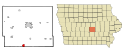
Location in Iowa
|
|
| Basic data | |
| Foundation : | 1843 (settled) 1867 (incorporated) |
| State : | United States |
| State : | Iowa |
| County : | Jasper County |
| Coordinates : | 41 ° 31 ′ N , 93 ° 6 ′ W |
| Time zone : | Central ( UTC − 6 / −5 ) |
|
Inhabitants : - Metropolitan Area : |
1,830 (as of 2010) 599,789 (as of 2013) |
| Population density : | 417.8 inhabitants per km 2 |
| Area : | 4.38 km 2 (approx. 2 mi 2 ) |
| Height : | 244 m |
| Postal code : | 50170 |
| Area code : | +1 641 |
| FIPS : | 19-53355 |
| GNIS ID : | 459177 |
| Website : | www.monroeia.com |
| Mayor : | Brian Briles |
Monroe is a small town (with the status " City ") in Jasper County in the US -amerikanischen State Iowa . In 2010 Monroe had 1,830 inhabitants, the number of which decreased slightly to 1,823 by 2013.
Monroe is part of the metropolitan area around Iowa's capital Des Moines .
geography
Monroe is located in the southeastern center of Iowa, in the eastern suburbs of Des Moines. The city lies on the watershed between the southern Skunk River and the Des Moines River , both of which flow into the Mississippi from the right . This forms the border with Illinois around 200 km east . The Iowa- Missouri border runs about 110 km south of Monroe, while the Missouri River forms the border with Nebraska about 250 km west .
The geographical coordinates of Monroe are 41 ° 31'20 "north latitude and 93 ° 06'07" west longitude. The city extends over an area of 4.38 km² and is the largest town within the Fairview Township .
Neighboring towns of Monroe are Newton (14 miles north), Reasnor (12.5 miles northeast), Otley (9.4 miles southeast), Knoxville (14.5 miles south), Runnells (14 miles west), Prairie City (15.1 km northwest) and Colfax (15.1 km north -northwest).
Des Moines city center is 46 km west-northwest. The closest other major cities are the Twin Cities ( Minneapolis and St. Paul ) in Minnesota (432 km north), Rochester in Minnesota (331 km northeast), Waterloo (169 km northeast), Cedar Rapids (161 km east-northeast), Iowas former Capital Iowa City (151 km east), the Quad Cities in Iowa and Illinois (234 km in the same direction), Chicago in Illinois (502 km also east), Peoria in Illinois (375 km east-southeast), Illinois' capital Springfield (430 km southeast), St. Louis in Missouri (499 km south-southeast), Columbia in Missouri (339 km south), Kansas City in Missouri (336 km south-southwest), Nebraska's largest city Omaha (272 km west-southwest), Nebraska's capital Lincoln (354 km in the same direction), Sioux City (345 km west-northwest), and South Dakota's largest city, Sioux Falls (498 km northwest).
traffic
The freeway Iowa Highway 163 forms the southern and western bypass of Monroe. The north-south running Iowa Highway 14 is the main road through downtown. All other roads are subordinate country roads, some unpaved roads and inner-city connecting roads.
With the Newton Municipal Airport there is a small airfield 24 km north-northeast. The nearest commercial airport is Des Moines International Airport, 57 km to the west .
history
| Population development | |||
|---|---|---|---|
| Census | Residents | ± in% | |
| 1880 | 982 | - | |
| 1890 | 952 | -3.1% | |
| 1900 | 917 | -3.7% | |
| 1910 | 800 | -12.8% | |
| 1920 | 936 | 17% | |
| 1930 | 936 | 0% | |
| 1940 | 1015 | 8.4% | |
| 1950 | 1108 | 9.2% | |
| 1960 | 1366 | 23.3% | |
| 1970 | 1389 | 1.7% | |
| 1980 | 1875 | 35% | |
| 1990 | 1739 | -7.3% | |
| 2000 | 1808 | 4% | |
| 2010 | 1830 | 1.2% | |
| 2013 estimate | 1823 | -0.4% | |
| 1880-2000 2010-2013 | |||
The first white settlers came to what is now the city in 1843 and named their settlement Tool's Point . The place was incorporated as an independent municipality in 1867 and renamed Monroe .
population
According to the 2010 census , Monroe had 1,830 people in 770 households. The population density was 417.8 people per square kilometer. Statistically, 2.38 people lived in each of the 770 households.
The racial the population was composed of 98.7 percent white, 0.3 percent African American, 0.1 percent Native American, 0.5 percent Asian and 0.1 percent from other ethnic groups; 0.3 percent were descended from two or more races. Hispanic or Latino of any race was 0.6 percent of the population.
24.4 percent of the population were under 18 years old, 59.4 percent were between 18 and 64 and 16.2 percent were 65 years or older. 50.1 percent of the population were female.
The average annual income for a household was 49,479 USD . The per capita income was $ 24,355. 8.4 percent of the population lived below the poverty line.
Individual evidence
- ↑ Business Record - Metro population Expands West - Census Bureau Retrieved on February 28, 2015
- ↑ City of Monroe - City Hall.Retrieved February 28, 2015
- ↑ a b c American Fact Finder. Retrieved February 28, 2015
- ↑ Distance information according to Google Maps. Accessed on February 28, 2015
- ↑ AirNav.com - Newton Municipal Airport Accessed on February 28, 2015
- ^ Iowa Data Center. Retrieved February 28, 2015
- ↑ City of Monroe. Retrieved February 28, 2015
