
Jackelberg (mountain)
| Jackelberg | ||
|---|---|---|
 South-east side of the Jackelberg, view from the lower Arzmoos |
||
| height | 1412 m | |
| location | Bavaria | |
| Mountains | Mangfall Mountains , Bavarian Prealps | |
| Coordinates | 47 ° 41 '48 " N , 12 ° 2' 47" E | |
|
||
| First ascent | unknown | |
| Development | * Jackelberg-Alm (private)
|
|
| particularities | Arzmoos waterfall (approx. 30 m) between Ober- and Unterarzmoos at the foot of the mountain | |

The Jackelberg is a mountain in the Bavarian Alps . It consists of a rocky and wooded ridge with two peaks , the 1412 meter high main peak in the west and the 1312 meter high eastern secondary peak. The Jackelberg Alm of the same name stands on its southern slope and the DAV's Kelheimer Hut is in the immediate vicinity .
geography
The Jackelberg is part of the Wendelstein group in the Mangfall Mountains . It forms the south-eastern extension of the Käserwand (1690 m above sea level ) and Wildalpjoch (1720 m above sea level) mountains , which separate it from the Kesselwand (1721 m above sea level) and the more famous Wendelstein mountain (1838 m above sea level) . The extensive Arzbach or Arzmoos valley connects to the south and east . At the eastern foot of the Jackelberg is the approx. 30 meter high Arzmoos waterfall , over which the Arzbach falls from the upper to the lower Arzmoos. There is an old abandoned tunnel near the waterfall . In the southern neighborhood of the mountain is the Sudelfeld with its ski facilities, in between the Sudelfeldstrasse ( Bundesstrasse 307 ) runs between Bayrischzell and Brannenburg (via the Tatzelwurmstrasse ) and the Auerbach .
geology
The mountain consists mainly of shell limestone , Partnachschichten and Wetterstein limestone . The undulating slope is covered by grasses and groups of trees, the ridge by conifers and weathered soil. The summit of Jackelberg lies with the peaks of the north-eastern neighbor mountains in the 4.9 km 2 large landscape conservation area "Advanced Soinkargebiet" .
Development
There is no paved path to the summit of the Jackelberg, which is why it is hardly frequented and requires sure-footedness. A summit book has been available since April 15, 2015. From the federal road 307, a short, paved private path leads past the Schweinsteigeralm to the Kelheimer Hütte and the Jackelberg-Alm. Various hiking routes lead along the Jackelberg, from Arzmoos there is a path on the east and south side towards the Kelheimer Hütte, in the west a popular path leads towards the Käserwand and Wildalpjoch.
Jackelberg Alm
The Jackelberg-Alm (1135 m above sea level) is a "hosted Alm"; that corresponds to the Jausenalm . The massive building with an attached barn is privately owned and is used for alpine farming in the summer and autumn months , mainly with dairy cows . There is a water source above the Alm. The Jackelberg-Alm offers a wide view over the steep southern slope to Dümpfel (1354 m above sea level), Schreckenkopf (1316 m above sea level) and to Sudelfeld , in good weather even as far as the Austrian Kaiser Mountains .
Kelheimer Hut
The Kelheimer Hütte was built in 1961–1964 as a section hut of the DAV Kelheim in the direct vicinity of the Alm on the Jackelberg. Overnight stays are possible.
Others
In Kolbermoor in the district of Rosenheim (which is also where the Jackelberg is located), Jackelbergstrasse is named after the mountain.
gallery

Arzmoos waterfall

Kelheimer Hut

Jackelberg Alm
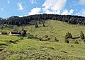
View of Jackelberg south side with Alm
Crossroads between Jackelberg-Alm and Kelheimer Hütte

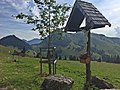
Wooden fountain on Jackelberg, in the background the Kaiser Mountains (AT)


Web links
- Website of the DAV Kelheim
- Report on an ascent of the Jackelberg
- YouTube video of a flight over the lower Arzmoos and the Alm
Individual evidence
- ↑ a b c OpenStreetMap Hike & Bike Map. Retrieved June 28, 2020 .
- ↑ a b Brombas Berge - Mountain News 2017-09-23. Retrieved June 28, 2020 .
- ↑ Hofmann, Peter R .: Paths in the Inntal An anthropospelaeological excursion guide to the caves of the lower Inntal between Rosenheim and Kufstein . Ed .: BoD - Books on Demand, 2013. Books on Demand, Norderstedt 2013, ISBN 978-3-8482-6956-3 , pp. 109 - 117 ( google.de [accessed June 28, 2020]).
- ↑ Mineral Atlas - Fossil Atlas. Retrieved June 28, 2020 .
- ↑ Geognostic Division of the Kgl. Bayer. Oberbergamtes (Hrsg.): Geognostische Jahreshefte. tape 3 . Munich 1890, p. 80 ( bayern.de [PDF]).
- ↑ Geognostic Division of the Kgl. Bayer. Oberbergamtes (Hrsg.): Geognostische Jahreshefte. tape 4 . Munich 1891, p. 124 ( bayern.de [PDF]).
- ↑ a b Agricultural heritage project - Jacklbergalm (Jackelberger Alm). Retrieved June 28, 2020 .
- ↑ Protection of parts of the landscape in the extended Soinkar area in the communities of Brannenburg, Flintsbach Am Inn and Oberaudorf. Retrieved August 22, 2020 .
- ↑ Alpine pastures and mountains - Jackelbergalm. Retrieved June 28, 2020 .
- ↑ 09 August 2014 09:05 am: Kelheim's highest house. Retrieved June 28, 2020 .