Köckritz (Harth-Pöllnitz)
|
Koeckritz
City of Harth-Pöllnitz
Coordinates: 50 ° 47 ′ 21 ″ N , 12 ° 2 ′ 41 ″ E
|
|
|---|---|
| Height : | 275 m above sea level NN |
| Incorporation : | January 1, 1957 |
| Incorporated into: | Köfeln |
| Postal code : | 07570 |
| Area code : | 036603 |
|
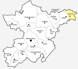
Location of Köckritz in Harth-Pöllnitz
|
|
|
The church
|
|
Köckritz is a district of the municipality of Harth-Pöllnitz in the Greiz district in Thuringia .
geography
Köckritz and Köfeln , which as of 2017 have a total of 263 inhabitants, form a unit in the towns surrounded by agricultural land.
history
Köckritz was first mentioned in documents in 1209 when Henricius de Kokeritz appeared as a witness. This is also the reference to the manor house in the village.
The church , built in 1740, stands on the site of a former chapel . A spherical acacia in the village was used as a picture on a seal of the village as early as 1807. Recently, there is a memorial there for the human sacrifices suffered in the war.
At the end of the 1990s, the new residential area "Am Rotacker" was built on the eastern edge of the village.
economy
The former manor , which is now privately owned again, and the agricultural cooperative determine the economy alongside services in the automotive industry.
Individual evidence
- ↑ a b c Harth-Pöllnitz community: Köckritz-Köfeln. Retrieved June 6, 2017 .
- ^ Wolfgang Kahl : First mention of Thuringian towns and villages. A manual. Rockstuhl Verlag, Bad Langensalza 2010, ISBN 978-3-86777-202-0 , p. 149

