Uhlersdorf
|
Uhlersdorf
Harth-Pöllnitz municipality
Coordinates: 50 ° 44 ′ 8 ″ N , 11 ° 56 ′ 26 ″ E
|
|
|---|---|
| Height : | 358 m |
| Residents : | 59 |
| Incorporation : | July 1, 1950 |
| Incorporated into: | Niederpöllnitz |
| Postal code : | 07570 |
| Area code : | 036607 |
|
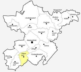
Location of Uhlersdorf in the municipality of Harth-Pöllnitz
|
|
|
Partial view of the church
|
|
Uhlersdorf is a hamlet-like district of the municipality of Harth-Pöllnitz in the Greiz district in Thuringia .
geography
| Niederpöllnitz Wetzdorf | Birkigt | |
| Tischendorf |

|
Forstwolfersdorf |
| Wiebelsdorf |
Neighboring villages (clockwise) are Wetzdorf , Niederpöllnitz , Birkigt , Forstwolfersdorf Wiebelsdorf and Tischendorf , all in the district of Greiz.
traffic
The villages are well connected via the local roads. The connection beyond the territory is provided via federal highway 2 .
history
The hamlet with 59 inhabitants was created from two estates. It was first mentioned in documents in 1356. The small church is of Gothic origin and has been rebuilt several times. In 1923 the estate managed 137 hectares. The owner was Mr. Fleischer and Alfred Telle was the tenant. After the Second World War , the property was expropriated according to the agreements of the victorious powers . The land and the inventory were given to resettlers and poor farmers. After the reunification in the GDR, the farmers reoriented themselves.
Individual evidence
- ^ Community of Harth-Pöllnitz: Uhlersdorf. Archived from the original on June 21, 2012 ; Retrieved July 22, 2017 .
- ^ Wolfgang Kahl : First mention of Thuringian towns and villages. A manual. Rockstuhl Verlag, Bad Langensalza 2010, ISBN 978-3-86777-202-0 , p. 291
- ↑ Jürgen Gruhl: Black Book of Land Reform Thuringia - Retrieved from the Internet on June 23, 2011.

