Niederpöllnitz
|
Niederpöllnitz
Harth-Pöllnitz municipality
Coordinates: 50 ° 45 ′ 25 ″ N , 11 ° 57 ′ 27 ″ E
|
|
|---|---|
| Height : | 318 m above sea level NN |
| Incorporation : | April 9, 1994 |
| Incorporated into: | Pollnitz |
| Postal code : | 07570 |
| Area code : | 036607 |
|
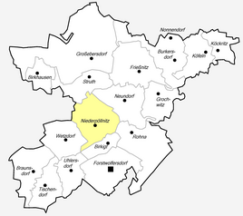
Location of Niederpöllnitz in the municipality of Harth-Pöllnitz
|
|
|
Niederpöllnitz concentrated feed plant
|
|
Niederpöllnitz is a district of the municipality of Harth-Pöllnitz in the Greiz district in Thuringia .
geography
Niederpöllnitz lies in an undulating landscape, wooded north of the village and interspersed with lakes.
history
Of the moated castle ( Burg Pöllnitz ) on the upper reaches of the Pöllnitzbach from Niederpöllnitz, only the high square tower and some remains of the wall have been preserved. Albertus Pullnitz was mentioned from 1130 . The Pullnitz were servants of the Margraves of Meißen . In 1238 Gottschalk von Pöllnitz was mentioned as a Wettin henchman. Later the Pöllnitz vassals were the governors of Weida . In the 15th century the castle came into the possession of the Lords of Planitz . After that, the owners often changed.
In 1266, however, it was first mentioned in a document.
In 1923 Carl Graf von Hohenthal was the owner of the 127 hectare estate in Niederpöllnitz. Mr. Siemer was the tenant. After the Second World War , the estate was expropriated according to the resolutions of the victorious powers and the land and the inventory were transferred to resettlers and poor farmers.
On July 1, 1950, the previously independent communities of Uhlersdorf and Wetzdorf were incorporated.
On April 9, 1994 Niederpöllnitz was incorporated into the municipality of Pöllnitz . On December 21, 1995, the company was reclassified to Harth-Pöllnitz.
Economy and Infrastructure
HaGeVa's concentrate plant is located at Niederpöllnitz train station . The Geological Sample Archive Thuringia (GEOPAT) is located in Niederpöllnitz.
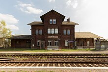
Niederpöllnitz has a train station on the railway line from Gera to Saalfeld . It was also the starting point of the Niederpöllnitz – Münchenbernsdorf railway , on which passenger traffic was discontinued in 1967. Regional traffic is now covered by RVG Regionalverkehr Gera / Land on a regular and a school route.
| line | Line course | Frequency (Mon-Fri) |
|---|---|---|
| 225 | Weida - Niederpöllnitz - Münchenbernsdorf | Every two hours |
| 227 | Weida - Frießnitz - Niederpöllnitz - Auma | School traffic |
Web links
Individual evidence
- ↑ Thomas Bienert: Medieval castles in Thuringia. Wartberg Verlag, 2000, ISBN 3-86134-631-1 , p. 98
- ↑ Michael Köhler: Thuringian castles and fortified prehistoric and prehistoric living spaces Jenzig-Verlag, 2001, ISBN 3-910141-43-9 , p. 189
- ^ Wolfgang Kahl : First mention of Thuringian towns and villages. A manual. 2010, ISBN 978-3-86777-202-0 , p. 189
- ↑ Excerpt from the commercial register of HaGeVa Handels und Grain Processing Company mbH (HRB 200408). Retrieved June 10, 2017 .
- ^ Thuringian State Institute for Environment and Geology (Ed.): Geological State Archive . accessed on June 28, 2019.


