Kaolack
| Kaolack | ||
|---|---|---|
|
|
||
| Coordinates | 14 ° 8 ′ N , 16 ° 5 ′ W | |
| Basic data | ||
| Country | Senegal | |
| Kaolack | ||
| Department | Kaolack | |
| ISO 3166-2 | SN-KL | |
| height | 8 m | |
| Residents | 233,708 (2013) | |
|
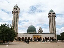
The mosque in Medina Baay
|
||
Kaolack [ kaɔˈlak ] ( Kawlax in Wolof) is the capital of the Kaolack region in Senegal and has over 200,000 inhabitants. The city is located southeast of the capital Dakar .
Geographical location
Kaolack is located in the north of the Kaolack region, 161 kilometers southeast of Dakar . The neighboring regional prefectures of Fatick in the northwest and Kaffrine in the east are 43 and 57 kilometers away, respectively.
Kaolack is located on the northern right bank of the Saloum , which is under the influence of the tides from its mouth in the Atlantic 78 kilometers west of the city to 28 kilometers east of it. These have washed out the meandering river bed and created an amphibious bank zone with many islands and river branches, which is several hundred meters wide and periodically flooded.
The location of Kaolack is characterized by the fact that, on the one hand, the Saloum is navigable up to this point for seagoing ships and, on the other hand, the flood- proof high banks of the Saloum are approached up to 2000 meters, thus making it easier to build a final bridge before the mouth.
climate
| Kaolack | ||||||||||||||||||||||||||||||||||||||||||||||||
|---|---|---|---|---|---|---|---|---|---|---|---|---|---|---|---|---|---|---|---|---|---|---|---|---|---|---|---|---|---|---|---|---|---|---|---|---|---|---|---|---|---|---|---|---|---|---|---|---|
| Climate diagram | ||||||||||||||||||||||||||||||||||||||||||||||||
| ||||||||||||||||||||||||||||||||||||||||||||||||
|
Average monthly temperatures and precipitation for kaolack
Source: wetterkontor.de
|
|||||||||||||||||||||||||||||||||||||||||||||||||||||||||||||||||||||||||||||||||||||||||||||||||||||||||||||||||||||||||||||||||||||||||||||||||||||||||||||||||||||
history
Kaolack was created not far from Kahone , the capital of the traditional kingdom of Saloum . Kahone was a central marketplace built around a sacred tree in the early 16th century. In the 17th and 18th centuries the place consisted of a number of different neighboring tribes who had wide, open fields around them. The slowly growing population became increasingly Muslim and the traditional religion that held its rites on the opposite island of Kouyong disappeared.
In the early 19th century, French influence on the Saloum River area increased when it came to finding merchandise that could replace the traditional slave trade. Since the middle of the 19th century, peanut production was established in the Saloum empire and kaolack became the preferred location for processing and shipping peanuts and peanut products. This is how the colonial power began to set up such facilities, around which the city of Kaolack was built.
Around the turn of the century 20th century Kaolack was an important center of Tijaniyyah - Order and since 1910 with a large branch ( Ribat ) Leona. Medina Mbàbba (Médina Mbaba in French) also called "Medina I", is named after Baabakar Njaay , whose nickname was "Mbàbba Njaay". He was Serer head of the village when it was incorporated into Kaolack. A second ribat opened in Medina Baye in the early 1930s. Medina Baay (Médina Base in French), also called "Medina II", is located in the northeast of the city. This Tijani order was founded by Allaaji Abdulaay Ñas's son, Ibrahim Baye Niass . His followers understand the word “Baay” to mean “father” (in Wolof ). In Arabic it means "The City of Baay". The Medina Baye religious community is now an international institution with branches in many cities such as Kano , Nigeria and Chicago , Illinois .
The branch line from the port to the Dakar – Niger railway line , built around 1911, gave the city a surge in growth: in 1925 there were still 5,600 inhabitants, nine years later it was 44,000.
Kaolack is the seat of the Kaolack diocese created in 1965 .
population
The last censuses showed the following population figures for the city:
| year | Residents |
|---|---|
| 1988 | 150.961 |
| 2002 | 172.305 |
| 2013 | 233,708 |
Town twinning
There are international communal ties too
-
 Mérignac , France
 -
 Aosta , Italy
 -
 Memphis, Tennessee , USA
In the 1960s and 1970s there was a twinning between Kaolack and the German city of Gelsenkirchen .
Economy and Transport
Kaolack is the center of the Senegalese peanut industry and an important trading center. 90% of the peanut oil obtained is exported.
While the branch line of the railway line to the port no longer exists and has been converted into a main traffic axis for urban road traffic, the port itself mainly consists of warehouses and other commercial buildings along a 600 meter long quay wall on the north bank of the Saloum, west of the city center. In a lagoon directly opposite the city center is in salt pans , which occupy an area of over 10 square kilometers, salt extraction operated with its own plant for shipment .
Kaolack is an important traffic junction in road traffic. The national road N 1 , which leads from Dakar in the west to Tambacounda and on over the Malian border to Kayes , runs through the city center. Here it is linked to the N 4 , which crosses the Saloum with a dam and a bridge of a total length of almost two kilometers and leads over the Gambian transit route of the Trans-Gambia Highway to Casamance to Ziguinchor .
Constricted between the outskirts of the cities of Kaolack and Kahone , the Kaolack airfield is located on the N1 two and a half kilometers east of the city center.
environment
Kaolack is considered to be one of the dirtiest cities in Africa: garbage is often left lying around on the streets and regular garbage disposal is only being set up. Sewers are mostly clogged or barely existent, the brackish water they contain is a strong source of infection for malaria and cholera pollution ; however, the drinking water supply has improved significantly. The unemployment is extremely high. The city is surrounded by a blue ring of hazy garbage stink from the surrounding landfills . Especially during the hot and humid months of the rainy season, the situation is difficult to bear for humans and animals. Epidemics like malaria , yellow fever and cholera break out almost every year. Only a few years ago, a wave of leprosy started here , which killed many people. The situation is only a little better in the western parts of the city. However, this cannot hide the fact that other parts of the city, such as Léona (Senegan: Lewna), have the worst environmental conditions.
sons and daughters of the town
- Ibrahim Baye Niass (1900–1975), Tijani Marabout
- Kéba Mbaye (1924–2007), lawyer and sports official
- Amadou Lamine Sall (* 1951), poet
- Abdou Aziz Sow (* 1953), politician
- Amadou M'Bodji (* 1984), football player
- Papa Diop (* 1986), soccer player
- Papy Djilobodji (* 1988), football player
See also
Web links
Individual evidence
- ^ Léona: Le center administratif de Kaolack
- ↑ Senegal: The most important places with statistics on their population
- ↑ USASC: Africa directory, Countries with sister cities - Embassies and Ambassadors
- ↑ http://www.gelsenkirchener-geschichten.de/viewtopic.php?t=4271
- ↑ http://www.senegalaisement.com/senegal/kaolack.php


