
Kaolack region
| Kaolack | |
|---|---|
| Capital | Kaolack |
| Residents | 960,875 (as of 2013) |
| surface | 5,357 km² |
| Population density | 179.4 inhabitants per km² |
| Geographical location | 14 ° 0 ′ N , 16 ° 0 ′ W |
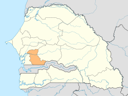
| map | |
  |
|
Kaolack is a region in Senegal . The capital of the same name Kaolack is located in the west of the region. The region borders the Gambia in the south .
history
Until 2008, the region consisted of the départements Kaffrine, Kaolack and Nioro. According to the state of the 2002 census, it covered an area of 15,449 km² and had 1,066,375 inhabitants. In 2008, the eastern Kaffrine department was spun off as the Kaffrine region from the Kaolack region. The area around Guinguinéo from the Fatick region was added , however. According to the 2013 census, an area of 5,357 km² and 960,875 inhabitants were documented for the reduced region.
structure
The Kaolack region is divided into three departments:
On the next structural levels, eight arrondissements, ten municipalities (Communes) and 31 rural communities (Communautés rurales) are to be named for 2013.
Individual evidence
- ↑ ANSD: Résultats préliminaires du Troisième Recensement Général de la Population et de l'Habitat du Sénégal de 2002 (RGPH-III) ( Memento of September 28, 2007 in the Internet Archive ) Data of the region on page 7 of the file
- ↑ Service Régional de la Statistique et de la Demographie de Kaolack: Situation economique et sociale regional 2013 Area and inhabitants Page 28 of the PDF file 1.29 MB
Web links
- Service Régional de la Statistique et de la Demographie de Kaolack: Situation economique et sociale regional 2013 PDF file 1.32 MB
- Map of the region in its old borders
- Kaolack region near Geonames with marking of the territory until 2008