
Kassianspitze
| Kassianspitze
Cima San Cassiano
|
||
|---|---|---|
 Kassianspitze from the southwest after fresh autumn snowfall, from the right Ritzlar, Hauptgipfel and Samspitze |
||
| height | 2581 m slm | |
| location | South Tyrol , Italy | |
| Mountains | Sarntal Alps | |
| Dominance | 1.5 km → Getrumspitze | |
| Notch height | 165 m | |
| Coordinates | 46 ° 42 '32 " N , 11 ° 29' 48" E | |
|
||
| Normal way | From the south, from the Latzfonser Kreuz | |

The Kassianspitze (Italian: Cima San Cassiano , 2581 m slm ) is a mountain on the southern edge of the eastern ridge of the Sarntal Alps and offers a comprehensive view of the Dolomites . The mountain is less than a kilometer north of the Latzfonser Kreuz , an old pilgrimage site with a small pilgrimage church and refuge . The north-east Fortschellscharte ( 2299 m slm ) separates the mountain from the rest of the ridge with Plankenhorn ( 2543 m slm ) and Schrotthorn ( 2590 m slm ). To the south is the Lückl ( 2376 m slm ) the saddle over which the path leads from the Sarntal side to the Latzfonser Kreuz. From there, the ridge running southwest to the Villanderer Berg no longer has any higher elevations.
To the south-east of the Kassianspitze is a secondary peak, the 2526 m slm high Ritzlar . Seen from the southeast, from the Eisack valley , Verdings or Latzfons , the Ritzlar obstructs the view of the main summit. To the southwest of the Kassianspitze is another secondary peak with a height of 2563 meters, which is also called the Samspitze . The main peak and both secondary peaks each have a summit cross.
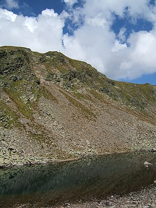
Kassianspitze from the south, in front the Kassiansee
Ritzlar from the northwest, from the connecting ridge to the Kassianspitze

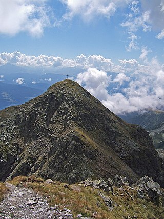
View from the Ritzlar to the Kassianspitze, on the left the Kassiansee


.jpg)
Routes
The usual ascent leads from the Latzfonser Kreuz ( 2311 m slm ) easily on a marked trail past the Kassiansee in just under an hour to the summit. To the Latzfonser Kreuz there are many climbing possibilities, for example from the east, from the Kühhof via the Klausner hut in 2 hours, or from the west, from Reinswald in the Durnholzer Tal , past the Getrumalm over the Lückl in about 3 hours.
Another possibility of ascent to the main summit of the Kassianspitze is the crossing of the Ritzlar. A little west of the hut you branch off the normal ascent path directly to the north, over climbing tracks and the somewhat exposed ridge you get to the Ritzlar. After the somewhat steep descent on the northwest side of the Ritzlar and crossing another ridge, the ridge leads almost evenly northwest to the Kassianspitze.
The south-western secondary summit, the Samspitze , can be reached after a short descent over the broad ridge, rising slightly on the somewhat narrow ridge. From the Samspitze, it is also possible to descend to the Lückl .
Literature and maps
- Barbara Klotzner (Ed.): Kompass hiking book, Bozen-Salten-Schlern-Ritten-Sarntal-Eggental . Fleischmann, Starnberg 1996, ISBN 3-87051-406-X
- Topographic hiking map, Monti Sarentini / Sarntal Alps , sheet 040, 1: 25,000, Casa Editrice Tabacco, ISBN 88-8315-054-6