Due to the great north-south expansion of the continent, there are very different climatic zones in Australia . The north is tropical , followed by a subtropical area, in the south the climate is temperate . The short-term weather and climate is mainly determined by three phenomena, the tropical low pressure belt , the trade wind zone and the subpolar westerly winds.
Over the year, the eastern states of Australia in particular are influenced by the Southern Oscillation and the associated weather phenomena El Niño and La Niña . El Niño years are usually accompanied by droughts (especially winter and spring), while La Niña leads to heavy rainfall and flooding across the eastern part of the country.
In the summer months from November to April there are northwest monsoons and heavy rains due to a low heat level . January is the wettest month with around 400 mm of precipitation. In addition, it comes across the Timor Sea to hurricanes , which at this latitude cyclones are called or Willy-Willies. This is favored by the high water temperatures. The temperatures are very high during this time (around 28 ° C, 32 ° C during the day, 25 ° C at night) and it is very humid because of the high humidity. In the winter months, May to October, the north remains dry due to a high pressure area (3 mm in July). Temperatures usually fluctuate around 25 ° C (30 ° C during the day, 20 ° C at night). The annual water temperatures are largely tropical (25–30 ° C); the annual precipitation is 1200-2000 mm with extremes of over 3500 mm in northern Queensland. See Darwin climate table.
South Australia
In summer, South Australia lies in the subtropical high pressure belt and remains largely free of precipitation apart from a few heat thunderstorms . Here there are mostly high temperatures (around 30 ° C during the day), similar to the Mediterranean . Cooler ocean currents such as the West Australian Current and the West Wind Drift do not allow the water temperatures to rise above 20 ° C in summer and bring rain in winter. But it remains mild (around 10 ° C). The climate in Tasmania is temperate and there is regular snowfall, especially in the interior of the island, in winter, which can persist on the mountain tops until summer. See climate tables for Adelaide, Hobart, Melbourne and Perth.
Western Australia
The west of the country lies in the westerly wind zone and is exposed to precipitation . However, the further north you go, the hotter and drier it gets. The temperatures are e.g. B. in Port Hedland between 31 ° C in summer and 20 ° C in winter, with an average rainfall of 300 mm.
Eastern Australia
Southeast trade winds bring uphill rain to the mountains of the east all year round. Temperatures are quite high all year round, thanks in part to the East Australian Current . With water temperatures of around 22 ° C, it ensures a subtropical and, further north, a tropical climate. In addition, there is a relatively high level of humidity, which ensures that the temperature differences between day and night remain very small. The precipitation is mostly spread over the summer half year, it falls altogether between 1000 and 1500 mm. In the mountains further to the west, temperatures and precipitation decrease sharply. That makes z. B. so noticeable that the winter in the capital Canberra regularly brings night frosts and in the higher mountains even winter sports are possible. See climate tables for Brisbane, Canberra, Sydney and Townsville.
Central Australia
The center of the continent remains largely dry all year round, 80 percent of the area of Australia is semi-arid and arid areas with less than 250 mm of precipitation per year. In addition, there is enormous heat, with summer temperatures often over 40 ° C. Except for occasional rainfall, it usually remains dry. In winter it is quite warm during the day at around 20 ° C, but temperatures can drop sharply at night. See Alice Springs climate table .
Climatic phenomena
January 1, 2006 was noted as the hottest start of the year in Australia since records began in 1858 . In Sydney itself, maximum temperatures of 44.7 degrees Celsius in the shade were measured at the official station on Observatory Hill at 4:24 p.m. The January temperature record of 45.3 degrees Celsius in the shadow of January 14, 1939 remained unchanged. According to the National Weather Service, 2005 is going to be the hottest year in Australian history since the temperature began to be recorded in 1858. In the first ten months of 2005, the values were 1.03 degrees Celsius above the 30-year average. Since 1988 there has been a clear trend towards higher average temperatures.
But there are also cold records. So is z. For example, at Christmas 2006, snow fell in the mountains southwest of Sydney, putting out most of the seasonal forest fires. But the holidays were also wet and cold in the metropolises : In Canberra it was barely 2 ° C at night, Melbourne had to be content with 16 ° C and continuous rain, although 25 ° C would be normal at this time of the year. On Tasmania, up to 5 centimeters of snow fell at 800–900 meters, in Hobart it was the second coldest Christmas at barely 14 ° C.
cards
Average daily maximum temperature in January (summer)
below 24 ° C
24 to 27 ° C
27 to 30 ° C
30 to 33 ° C
33 to 36 ° C
36 to 39 ° C
above 39 ° C
Average daily maximum temperature in July (winter)
below 15 ° C
15 to 18 ° C
18 to 21 ° C
21 to 24 ° C
24 to 27 ° C
27 to 30 ° C
above 30 ° C
Number of rainy days (i.e. days with more than 0.2 mm of precipitation)
under 20
20 to 40
40 to 80
80 to 120
120 to 160
over 160
Rough representation of the different climatic regions


 Average daily maximum temperature in January (summer)
 Average daily maximum temperature in July (winter)
 Number of rainy days (i.e. days with more than 0.2 mm of precipitation)
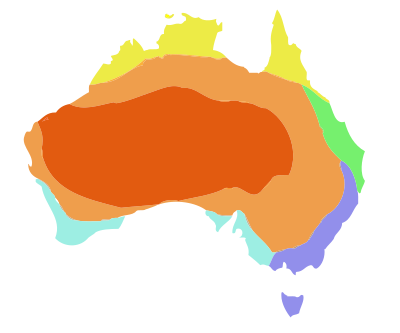 Rough representation of the different climatic regions


