
Kollumerland en Nieuwkruisland
 flag |
 coat of arms |
| province |
|
| local community | Noardeast-Fryslân |
|
Area - land - water |
116.35 km 2 109.6 km 2 6.75 km 2 |
| Residents | 12,768 (Sep 30, 2018) |
| Coordinates | 53 ° 17 ' N , 6 ° 9' E |
| Important traffic route |
|
| prefix | 0511, 0594 |
| Postcodes | 9291-9299, 9851-9853 |
| Website | Homepage of Kollumerland en Nieuwkruisland |
 |
|
Kollumerland en Nieuwkruisland ( ) (official abbreviation: Kollumerland ca , West Frisian Kollumerlân , Gronings Kölmerland en Nijkruusland ) was a municipality in the province of Friesland ( Netherlands ). It had 12,768 inhabitants (as of September 30, 2018).
places
The administrative seat was the large village of Kollum , which has about 5,600 inhabitants. Other places in the municipality were (in brackets the Frisian name, if it differs significantly from the Dutch, the possible number of inhabitants (2006), as well as a K if the village has a church worth seeing, and an M if there is a beautiful old windmill there ) :
- Augsbuurt or: Lutjewoud (Lytsewâld; 75; K)
- Burum (Boerum; 625; M)
- Kollumerpomp (De Pomp; 500)
- Kollumerzwaag (Kollumersweach; 3,100; K)
- Munnekezijl (Muntsjesyl; 500)
- Oudwoude (Aldwâld; 850; K)
- Thongs (350; K)
- Veenklooster (100)
- Wharf stermoles (200)
- Westergeest (600; K)
- Zwagerbosch (Sweagerbosk; 600).
Location and economy
The municipality is located in the extreme northeast of the province and borders the province of Groningen . In some villages Frisian is not spoken, but a Lower Saxon dialect related to Groningsch , including the Kollumerpompsters in Kollumerpomp. Outside the municipality, about 3.5 km south of Kollum, the Buitenpost small train station is located on the Groningen - Leeuwarden railway line . A good road connects Kollum with Dokkum, 14 km northwest, and to the south with the trunk road between Groningen and Leeuwarden, which is not a motorway.
history
- Kollum was created in the early Middle Ages . It was in the 11th – 13th Century a settlement along a dike in the moor . Gradually the bog was reclaimed and turned into arable and pasture land. In the 17th century, a canal from Dokkum to the Wadden Sea was dug for shipping . This canal ran through Kollum, which brought the village economic prosperity through trade and shipping for 150 years.
- Kollumerzwaag was first mentioned in a document in 1443. Zwaag , Frisian: sweach , is an old word for "meadow".
- At Veenklooster there was a monastery of the Premonstratensian choirs in the 12th century . This monastery was closed after the Reformation in the 16th century. The Fogelsanghstate Manor was built in its place in 1646 .
- In 1580 the Nieuw-Kruisland polder was diked . The villages of Kollumerpomp, Munnekezijl and Warfstermolen were established in this new country. Warfstermolen was built on the old sea dike, which was no longer needed to defend against seawater. Inland there was a barren heathland that was also made arable until the 18th century; here was u. a. De Triemen.
Attractions
These are concentrated in the tiny Veenklooster. Over there:
- the mansion Fogelsanghstate equipped with furniture, pictures, etc. from the 18th and 19th centuries. The house also has a fine collection of porcelain from the early 19th century. It is privately owned by the well-known Van Harinxma thoe Slooten family . This family donated the beautiful house to a foundation, which will open it for viewing from the beginning of May to the end of October. The country estate is surrounded by a very beautiful park ( landscape style , 19th century). This park attracts thousands of lovers of historical garden culture every year.
- an agricultural museum (Landbouwmuseum) , where tools, household items and utensils from the farm from the period 1850–1950 are shown.
- De Munnik (The Monk) information center , a local museum and tourist office.
Kollum has two beautiful, old churches and several listed houses in the town center. There are also two campsites, but no hotels. The place is a good starting point for excursions in the area, e.g. B. to the Wadden Sea .
photos
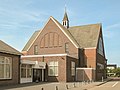
Kollumerzwaag, the reformed church (reformeerd)

Kollumerzwaag, the Reformed Church (Nederlands Hervormd)

Veenklooster, country house: de Fogelsangh State

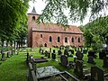
Burum, the reformed church
Westergeest Reformed Church

Between Burum and Kollum, parabolic antenna (NSO-grondstation)


politics
fusion
On January 1, 2019, Kollumerland en Nieuwkruisland merged with Dongeradeel and Ferwerderadiel to form the new municipality of Noardeast-Fryslân .
Distribution of seats in the municipal council
The local elections on March 19, 2014 resulted in the following distribution of seats:
| Political party | Seats | |||
|---|---|---|---|---|
| 2002 | 2006 | 2010 | 2014 | |
| FNP | 4th | 3 | 3 | 4th |
| CDA | 6th | 5 | 5 | 4th |
| VVD | 1 | 2 | 3 | 3 |
| PvdA | 2 | 3 | 2 | 2 |
| ChristenUnie | 2 | 2 | 2 | 2 |
| total | 15th | 15th | 15th | 15th |
Due to the merger on January 1, 2019, the elections for the council of the new Noardeast-Fryslân municipality took place on November 21, 2018.
mayor
From 2001 to the time the municipality was dissolved, Bearn Bilker ( CDA ) was the acting mayor of the municipality. His colleagues included Jan Benedictus ( FNP ), Jelle Boerema ( VVD ), Paul Maasbommel ( PvdA ) and the municipal secretary Harmen Jonker .
Web links
- Website of the municipality (Dutch)
- Agricultural Museum website (Dutch)
- Fogelsangh State website (Dutch, German, English)
Individual evidence
- ↑ Bevolkingsontwikkeling; regio per maand . In: StatLine . Centraal Bureau voor de Statistiek , accessed January 1, 2019 (Dutch)
- ↑ 'Noardeast-Fryslân' nieuwe gemeentenaam DFK Gemeente Kollumerland en Nieuwkruisland, accessed on June 17, 2018 (Dutch)
- ↑ Result of the local elections: 2010 2014 , accessed on June 17, 2018 (Dutch)
- ↑ Allocation of seats in the municipal council: 2002 ( Memento of the original dated June 15, 2018 in the Internet Archive ) Info: The archive link was inserted automatically and has not yet been checked. Please check the original and archive link according to the instructions and then remove this notice. 2006 2010 2014 , accessed June 17, 2018 (Dutch)
- ↑ Herindelingen Kiesraad , accessed on June 17, 2018 (Dutch)
- ↑ Collegeleden Gemeente Kollumerland en Nieuwkruisland, accessed on June 17, 2018 (Dutch)