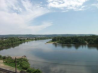
Condoma
|
Kondoma Кондома |
||
|
Course of the condoma (Кондома) in the south of the catchment area of the Tom |
||
| Data | ||
| Water code | RU : 13010300112115200009370 | |
| location | Kemerovo Oblast ( Russia ) | |
| River system | If | |
| Drain over | Tom → Ob → Arctic Ocean | |
| source | at the crest Bijskaja Griwa 52 ° 25 '44 " N , 88 ° 14' 31" O |
|
| Source height | approx. 800 m | |
| muzzle | at Novokuznetsk in the Tom coordinates: 53 ° 44 '54 " N , 87 ° 11' 31" E 53 ° 44 '54 " N , 87 ° 11' 31" E |
|
| Mouth height | approx. 200 m | |
| Height difference | approx. 600 m | |
| Bottom slope | approx. 1.5 ‰ | |
| length | 392 km | |
| Catchment area | 8270 km² | |
| Discharge at the Taschtagol A Eo gauge : 842 km² Location: 315 km above the mouth |
MQ 1957/1994 Mq 1957/1994 |
15.5 m³ / s 18.4 l / (s km²) |
| Discharge at the Kondoma A Eo gauge : 2510 km² Location: 212 km above the mouth |
MQ 1957/2000 Mq 1957/2000 |
44 m³ / s 17.5 l / (s km²) |
| Discharge at the Kusedejewo A Eo gauge : 7080 km² Location: 73 km above the mouth |
MQ 1936/2000 Mq 1936/2000 |
122 m³ / s 17.2 l / (s km²) |
| Left tributaries | Antrop | |
| Right tributaries | Mundybasch | |
| Medium-sized cities | Ossinniki | |
| Small towns | Tashtagol , Kaltan | |
|
Kondoma at Ossinniki |
||
The 392 km long Kondoma ( Russian Кондома ) is a left tributary of the Tom in southern Western Siberia in Russia .
The Kondoma rises on the ridge Biyskaya Griva ( Бийская Грива ) at about 800 m . It continues to flow - always on the territory of the Kemerovo Oblast - through the mountainous region between the Altai and the Sayan Mountains , named after the Schoren people, before finally flowing into the Tom in the south of the Kuzbass near Novokuznetsk (at around 200 m ).
The catchment area of the Kondoma covers 8,270 km². At Kusedejewo, 73 km from the estuary, the mean water flow is 130 m³ / s. In the lower reaches, the river is more than 100 m wide in places, up to 2 m deep, the flow velocity is 1.0 m / s. The most important tributaries are the Mundybasch ( Мундыбаш ) on the right and the Antrop ( Антроп ) on the left .
The cities of Tashtagol , Kaltan and Ossinniki lie on the river . In the middle and lower reaches of the river from Tashagol, the valley is heavily developed for mining and industry in sections, with corresponding negative effects on ecology. The railway line and the Novokuznetsk - Tashtagol road run partially in the valley .
The condoma freezes from late October / November to late April / May. It is not navigable, but can be used for logging.
Individual evidence
- ↑ a b Condoma in the State Water Register of the Russian Federation (Russian)
- ↑ a b Article Kondoma in the Great Soviet Encyclopedia (BSE) , 3rd edition 1969–1978 (Russian)
- ↑ Condoma at the Taschtagol gauge - hydrographic data from R-ArcticNET
- ↑ Kondoma at the Kondoma gauge - hydrographic data at R-ArcticNET
- ↑ Condoma at the Kusedejewo gauge - hydrographic data from R-ArcticNET

