Imst power plant
| Imst power plant | ||
|---|---|---|
| location | ||
|
|
||
| Coordinates | 47 ° 12 '44 " N , 10 ° 43' 17" E | |
| country |
|
|
| place | Imsterberg | |
| Waters | Inn , Pitze | |
| power plant | ||
| operator | TIWAG | |
| construction time | 1953-56 | |
| Start of operation | 1956 | |
| technology | ||
| Bottleneck performance | 89 megawatts | |
| Average height of fall |
143.5 m | |
| Expansion flow | 85 m³ / s | |
| Turbines | 3 Francis turbines | |
| Others | ||
| Website | https://www.tiwag.at | |
| was standing | 2019 | |
The Imst power plant is a run-of-river power plant on the Inn in the municipality of Imsterberg in the Upper Inn Valley .
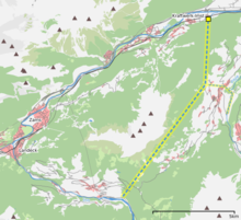
At Landeck , the Inn flows in a wide arc to the west around the Venet mountain . For the Imst power plant, the Inn is dammed by a weir ▼ below the Pontlatzer bridge near Prutz and passed through a 12.3 km long pressure tunnel under the mountain. The Inn, on the other hand, covers around 26 kilometers of river between the diversion at Prutz and the mouth of the power station outlet at Imst. In addition to the Inn, the Pitze is also used. This is collected at Wenns ▼ and fed to the main tunnel via a tunnel.
The power house with the turbines and generators is located in a cavern. The water flows back into the Inn via the underwater tunnel and a short open channel that crosses under the Arlbergbahn .
Instead of directing the water back into the Inn, the plan is to build the Haiming-Imst power plant downstream and connect it to the underwater area of the Imst power plant via an approximately 14 km long tunnel.
swell
- https://www.tiwag.at
- Extract from the Tirol Water Book
- [1] Geological results from the construction of the Prutz-Imst hydropower plant by TIWAG (Tyrol), Oskar Schmidegg
- Haiming-Imst project
- https://ehyd.gv.at Source for the course of the tunnels

