
Kreuzspitze (Allgäu Alps)
| Cross point | ||
|---|---|---|
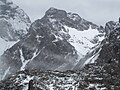
 Kreuzspitze from the northeast from the Schochenspitze ( 2069 m ) above the Steinkarspitze ( 2067 m ) |
||
| height | 2367 m | |
| location | Border Bavaria , Germany / Tyrol , Austria | |
| Mountains | Hochvogel and Rosszahn group , Allgäu Alps | |
| Dominance | 0.2 km → Hochvogel | |
| Notch height | 86 m ↓ Kaltwinkelscharte | |
| Coordinates | 47 ° 23 '2 " N , 10 ° 25' 51" E | |
|
||
| rock | Main dolomite | |
| Normal way | Cable-insured southern flank | |

The Kreuzspitze is a 2367 m high mountain peak in the Allgäu Alps , over which the border between Germany and Austria runs. The Kreuzspitze is not to be confused with the Kreuzspitze in the neighboring Ammergau Alps.
Location and surroundings
The summit, located in the Hochvogel and Rosszahn group , rises in the ridge that extends the Rauhhornzug from the Kesselspitze ( 2284 m ) south to the Hochvogel ( 2592 m ). The Kreuzspitze is separated from the latter by the Kaltwinkelscharte ( 2281 m ) to the southeast. In the north is the Balkenscharte ( 2172 m ), which goes over to the Fuchskarspitze ( 2314 m ). Another mountain range branches off to the west from the Kreuzspitze, which is the first elevation to bear the Weittalkopf ( 2289 m ). The firn field Im Kalten Winkel lies under the eastern flank .
The district on which the Kreuzspitze is located is Bad Hindelang on the German side and Hinterhornbach on the Austrian side .
Origin of name
The Kreuzspitze was first mentioned in 1834 as a cross head in the Topographical Atlas of Bavaria. In 1844 it was mentioned as after the Kreuzspitz in the revised description of the Bavarian state border. The name could possibly have been given by a border cross on the summit, as on the Kreuzkopf, a little to the west . Since the summit was also an important border point, an associative naming would also be conceivable.
Ascent
Support points for the ascent of the Kreuzspitze are the Prinz-Luitpold-Haus ( 1846 m ), which is located to the northwest, and the village of Hinterhornbach.
Normal way
Typically, the cross peak within an ascent of high bird from northwest to southeast is exceeded, wherein the rocky peak flanks are covered wire and slip resistance and vertigo assume. However, the marked path runs just below the summit, the ascent of the summit is pathless and requires surefootedness. Before the border was opened in 1997 as part of the Schengen Agreement , this crossing was important for the popular high bird ascent, especially when the border police closed the Kalten Winkel.
The normal route to the Kreuzspitze leads from the Kaltwinkelscharte over the short south flank secured by wire rope. The Kaltwinkelscharte can be reached in different ways, for example via the bar notch from the Prinz-Luitpold-Haus or as a junction from the Jubiläumsweg . An ascent continues from Hinterhornbach over the Fuchsensattel ( 2039 m ) into the Kaltwinkelscharte, and crossing the Hochvogel via the Bäumenheimer Weg ( level of difficulty I , officially closed since 2014 due to the acute risk of rock falls) ended in the Kaltwinkelscharte.
Further climbs
There are also two ridge climbs that lead to the summit as climbing routes: from the north via the Balkenspitzgrat (III–) and via the west ridge (IV).
photos

With Hochvogel from the northeast
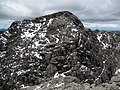
Northwest flank
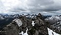
South flank
summit

First cross placed in 2018
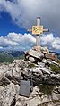
Refurbished summit cross 2020


Web links
Individual evidence
- ^ A b c Ernst Zettler, Heinz Groth: Alpine Club Guide - Allgäu Alps . 12th, completely revised edition. Bergverlag Rudolf Rother , Munich 1985, ISBN 3-7633-1111-4 (p. 275 f.).
- ↑ Bavarian Surveying Administration : BayernViewer 2.0 ( Memento of the original from March 3, 2016 in the Internet Archive ) Info: The archive link was inserted automatically and has not yet been checked. Please check the original and archive link according to the instructions and then remove this notice. . Retrieved April 16, 2012.
- ↑ a b Federal Office for Metrology and Surveying Austria: Austrian Map online (Austrian map 1: 50,000) . Retrieved April 16, 2012.
- ^ Thaddäus Steiner : Allgäu mountain names . 2nd Edition. Kunstverlag Josef Fink, Lindenberg 2008, ISBN 978-3-8987-0389-5 (p. 124).
- ↑ Dieter Seibert: Alpine Club Guide alpine - Allgäu Alps and Ammergau Alps . 17th edition. Bergverlag Rother, Munich 2008, ISBN 978-3-7633-1126-2 (p. 310 ff.).