Extinguishing rod
|
Extinguishing rod
Eichenzell municipality
Coordinates: 50 ° 29 ′ 53 ″ N , 9 ° 40 ′ 44 ″ E
|
|
|---|---|
| Height : | 280 m above sea level NHN |
| Area : | 1.58 km² (LAGIS) |
| Residents : | 1227 (Dec. 31, 2013) |
| Population density : | 777 inhabitants / km² |
| Incorporation : | August 1, 1972 |
| Postal code : | 36124 |
| Area code : | 06659 |
|
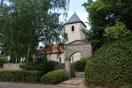
Historic fortified church (1386) since 1986 Marienkapelle
|
|
Deleterod is a district of the municipality of Eichenzell in the eastern Hessian district of Fulda .
geography
Geographical location
Deleterod is located in the western foothills of the Rhön . The Fulda River runs east of Lassenrod and the Fliede River to the west .
Neighboring communities
Deleterod borders in the southwest and south on Kerzell , in the north on Fulda-Bronnzell and in the east on Eichenzell.
history
Deleterod is located south of Fulda at the junction of Frankfurter and Würzburger Strasse. It was first mentioned in a document in 1303 as "Leisenrod" (clearing of the Leisse family). The Gothic fortified church, built around 1386, is now a St. Mary's Chapel and at the same time the town's landmark. The new Church of the Resurrection was consecrated in 1968.
On August 1, 1972, the previously independent municipality of Lassenrod was incorporated into the previously formed large municipality of Eichenzell as part of the regional reform in Hesse by virtue of state law . From 1996 to 2008 Rudolf Breithecker ( SPD ) was the previous mayor of Lassenrod, Mayor of Eichenzell. Rüdiger Maluck is the head of the village of Lassenrod. In June 2007 the new community center was completed.
Culture and sights
- "Dreieckbildstock" from 1711 in the street "Am Bildstock"; unique in the Fulda region.
Web links
- Deleterod district. In: Internet presence. Eichenzell municipality
- Deleterod, District of Fulda. Historical local dictionary for Hessen. (As of September 18, 2015). In: Landesgeschichtliches Informationssystem Hessen (LAGIS).
- Literature on clearing rod in the Hessian bibliography
Individual evidence
- ↑ Population statistics of the Fulda district , accessed in September 2015.
- ↑ Law on the reorganization of the districts of Fulda and Hünfeld and the city of Fulda (GVBl. II 330-14) of July 11, 1972 . In: The Hessian Minister of the Interior (ed.): Law and Ordinance Gazette for the State of Hesse . 1972 No. 17 , p. 220 , § 10 ( online at the information system of the Hessian state parliament [PDF; 1,2 MB ]).
- ^ Federal Statistical Office (ed.): Historical municipality directory for the Federal Republic of Germany. Name, border and key number changes in municipalities, counties and administrative districts from May 27, 1970 to December 31, 1982 . W. Kohlhammer GmbH, Stuttgart and Mainz 1983, ISBN 3-17-003263-1 , p. 395 .
- ↑ Michael Mott : Unique wayside shrine in the Fuldaer Land / The "triangle shrine" from Lassenrod - once a stop of the Walldürner foot pilgrimage; in: "Buchenblätter" of the Fuldaer Zeitung, 63rd year, No. 29, Nov. 27, 1990, p. 115.

