Rothemann
|
Rothemann
Eichenzell municipality
Coordinates: 50 ° 27 ′ 51 ″ N , 9 ° 42 ′ 23 ″ E
|
|
|---|---|
| Height : | 292 m above sea level NHN |
| Area : | 7.73 km² |
| Residents : | 1414 (December 13, 2019) |
| Population density : | 183 inhabitants / km² |
| Incorporation : | December 31, 1971 |
| Postal code : | 36124 |
| Area code : | 06659 |
|
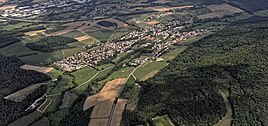
Rothemann from above
|
|
Rothemann is the second largest district of the large municipality of Eichenzell in the eastern Hessian district of Fulda .
Geographical location
Rothemann is located in the western foothills of the Rhön around 3 km south-southeast of the core town of Eichenzell between Welkers in the north-north-east, Döllbach in the south-east, Hattenhof in the west and Kerzell in the north-west. It is located between the mountains and elevations Steinhauk ( 367 m above sea level ) in the north, Burghardser Kopf ( 435.8 m ) in the east-southeast, Rippberg ( 484.5 m ) in the south-south-west and the Alter Turm ( 347.7 m ) in the north-west . It is traversed by the Döllbach Fliede tributary . The federal highway 27 runs through the village and the federal highway 7 passes to the northeast .
history

The village is first mentioned in 1012 as Rodenmannum (= settlement of the clearing men) and was part of the Fulda monastery . An altar is mentioned in 1510. In 1594 and 1812 it was a daughter church of Hattenhof.
Reorganization
On December 31, 1971, the previously independent municipality of Rothemann was incorporated into the municipality of Eichenzell as part of the regional reform .
Infrastructure
In the village there are among others:
- a Catholic parish church of St. Barbara from 1963
- a sports field, a gym and a football field
- several playgrounds
- a historic and a new village fountain
- the historical watchtower " Old Tower " preserved as a ruin
- a club house in the former school
- a town house
- a kindergarten
- a bakery
Individual evidence
- ^ Rothemann, District of Fulda. Historical local dictionary for Hessen. (As of October 19, 2018). In: Landesgeschichtliches Informationssystem Hessen (LAGIS).
- ↑ Numbers, data & facts. In: website. Eichenzell municipality, accessed December 2019 .
- ^ Federal Statistical Office (ed.): Historical municipality directory for the Federal Republic of Germany. Name, border and key number changes in municipalities, counties and administrative districts from May 27, 1970 to December 31, 1982 . W. Kohlhammer GmbH, Stuttgart and Mainz 1983, ISBN 3-17-003263-1 , p. 394 .
Web links
- Rothemann district. In: Internet presence. Eichenzell municipality
- Rothemann ... my village. Local history, information. In: www.rothemann.de. Association of Rothemann e. V.
- Rothemann, District of Fulda. Historical local dictionary for Hessen. In: Landesgeschichtliches Informationssystem Hessen (LAGIS).
- Literature on Rothemann in the Hessian Bibliography

