La Pobla de Segur
| Municipality of La Pobla de Segur | ||
|---|---|---|
| coat of arms | Map of Spain | |

|
|
|
| Basic data | ||
| Autonomous Community : |
|
|
| Province : | Lleida | |
| Comarca : | Pallars Jussà | |
| Coordinates | 42 ° 15 ′ N , 0 ° 58 ′ E | |
| Height : | 524 msnm | |
| Area : | 32.9 km² | |
| Residents : | 2,984 (Jan 1, 2019) | |
| Population density : | 90.7 inhabitants / km² | |
| Municipality number ( INE ): | 25171 | |
| administration | ||
| Mayor : | Lluís Bellera Juanmartí (ERC) | |
| Website : | www.pobladesegur.org | |
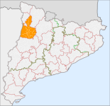
| Location of the municipality | ||

|
||
La Pobla de Segur is a municipality in the Spanish region of Catalonia .
geography
The Flamisell divides La Pobla de Segur into two halves and flows into the Noguera Pallaresa here .
In addition to the main town, there are the districts of Montsor, Puimanyons and Sant Joan de Vinyafrescal.
| 1900 | 1910 | 1920 | 1930 | 1940 | 1950 | 1960 | 1970 | 1981 | 1991 | 1996 | 2001 | 2005 |
|---|---|---|---|---|---|---|---|---|---|---|---|---|
| 1,549 | 1,529 | 1,775 | 1,883 | 2,511 | 2,469 | 3,288 | 3,513 | 3,356 | 3.114 | 2,997 | 2,832 | 3,043 |
Attractions
- Romanesque monastery of Sant Pere de les Maleses
- Museu dels Raiers
Personalities
- Ceferí Rocafort (1872–1917), geographer, archaeologist and historian
- Joan Borrell (1888–1951), sculptor
- Enric Porta (1898–1993), painter
- Pedro Cortina Mauri (1908–1993), politician
- Josep Borrell (* 1947), politician
- Carles Puyol (* 1978), football player
Parish partnership
- Le Fousseret in the Haute-Garonne department , France
Web links
Commons : La Pobla de Segur - Collection of images, videos and audio files
- Ajuntament de La Pobla de Segur in Catalan
- Information from the Generalitat de Catalunya on La Pobla de Segur in Catalan
- Information from the Catalan Statistics Institute on La Pobla de Segur in Catalan
Individual evidence
- ↑ Cifras oficiales de población resultantes de la revisión del Padrón municipal a 1 de enero . Population statistics from the Instituto Nacional de Estadística (population update).

