
Lambsbach
|
Lambsbach Lamsbach |
||
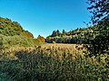
 Lambabach within the Lambsbachtal nature reserve |
||
| Data | ||
| Water code | DE : 264252 | |
| location | Rhineland-Palatinate | |
| River system | Rhine | |
| Drain over | Blies → Saar → Moselle → Rhine → North Sea | |
| source | at Lambsborn 49 ° 21 ′ 45 ″ N , 7 ° 26 ′ 14 ″ E |
|
| Source height | approx. 311 m above sea level NHN | |
| muzzle | At Schwarzenbach in the Blies coordinates: 49 ° 17 ′ 7 ″ N , 7 ° 18 ′ 48 ″ E 49 ° 17 ′ 7 ″ N , 7 ° 18 ′ 48 ″ E |
|
| Mouth height | 222 m above sea level NHN | |
| Height difference | approx. 89 m | |
| Bottom slope | approx. 5.9 ‰ | |
| length | 15.2 km | |
| Catchment area | 33.934 km² | |
| Drain |
MNQ MQ |
100 l / s 0.51 |
| Left tributaries | Schwobach, Mörsbach, Budenbach, Collingbach, Patronbach, Emilienfloß, Kleinerbach, Audenkellertalbach | |
| Right tributaries | Hirschbrunnen, Vierherrnbach, Bear raft, Talwiesgräben, | |
| Medium-sized cities | Homburg | |
| Communities | Lambsborn , Bechhofen , Käshofen | |
The Lambsbach is an orographically left tributary of the Blies in southwestern Rhineland-Palatinate and in eastern Saarland . The Lambsbach drains the Sickinger Höhe , thus the northernmost part of the Westrich plateau .
geography
The Lambsbach rises in the small town of Lambsborn , the place name indicates this fact: Born means source here . The stream flows through the Lambsbachtal, a narrow, largely natural meadow valley that is framed on both sides by wooded hills. A small part of the valley is designated as a nature reserve Lambsbachtal .
The purpose of protection is mentioned
"... the preservation of the valley floodplain with its meandering water, the tall herbaceous meadows, reed areas, Großseggenriedern as well as swamp areas as habitats and partial habitats of rare animal species as well as locations of rare plant species and plant communities."
In its further course the Lambsbach flows through Bechhofen and west past the Käshofen situated higher up . The Lambsbach crosses the state border on the L 462 state road and continues through Kirrberg in Saarland , past the Emilienruhe, Ebersberg and Audenkellerhof and finally as the local border between Schwarzenbach and Schwarzenacker .
The brook flows into the Blies between Schwarzenbach, Schwarzenacker and Wörschweiler only a few meters from the Erbach mouth in the Mastau .

The Lambsbach spring in Lambsborn
Reed meadow in the Lambsbach valley between Kirrberg and Emilienruhe

The Meerwoog valley between Merburg and Bechhofen

Lambsbachtal near Käshofer Straße


See also
- List of nature reserves in the district of Südwestpfalz
- List of nature reserves in the Saarpfalz district
Web links
- The Lambsbach. ( Memento from April 22, 2008 in the Internet Archive ) Website of the community of interests of the Homburger fishing clubs with many photos
Individual evidence
- ↑ Map service of the landscape information system of the Rhineland-Palatinate nature conservation administration (LANIS map) ( notes )
- ↑ Topographic map 1: 25,000
- ↑ a b GeoExplorer of the Rhineland-Palatinate Water Management Authority ( information )
- ↑ Saar river system ( Memento from March 4, 2016 in the Internet Archive ) Monitoring program according to Art. 8 WFD, Ministry for the Environment of the Saarland, 2007, on: Lebige-prims.de (pdf; 65 kB)
- ↑ a b Ordinance on the “Lambsbachtal” nature reserve. Retrieved May 20, 2015 .
- ↑ NSG Lambsbachtal. ( Memento from May 27, 2010 in the Internet Archive ) In: saarland-lexikon, accessed on February 18, 2012.