Konin County

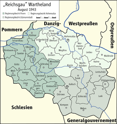
Konin County was the name of a German administrative unit in occupied Poland (1939-45) during World War II .
prehistory
1793 to 1807
After the Second Partition of Poland from 1793 to 1807, the area around the western Polish cities of Konin and Peisern belonged temporarily to the Prussian province of South Prussia as the Konin and Peisern districts .
1815 to 1817
After the Congress of Vienna on May 15, 1815, the area around the city of Pyzdry was again part of Prussia as the Peysern district , but was given back to Congress Poland on November 11, 1817 . The rest of the district continued to belong to Prussia until 1919 under the name Wreschen District .
Administrative history
At the beginning of the Second World War , German troops occupied the western Polish powiat Konin , the county town of Konin was captured on September 14, 1939.
On October 26, 1939, the powiat was annexed to the German Reich under the designation Landkreis Konin , which as a unilateral act of violence was ineffective under international law. The district became part of the administrative district Hohensalza in the Reichsgau Wartheland .
The seat of the German district office was the district town of Konin .
The German occupation ended with the invasion of the Red Army in January 1945.
politics
Land Commissioner
- 1939 : Wild
District administrators
- 1939-1945: Wild
Municipal structure
The district of Konin was divided into two municipalities (Konin and Słupca) and 29 rural communities, which were grouped into administrative districts .
expansion
Konin County had an area of 2383 km².
population
The powiat Konin had 210,745 inhabitants in 1939 (88% of them Poles), the Konin district, however, had only 186,232 inhabitants in 1941.
The German occupation authorities expelled over 21,000 Poles from the area between December 1, 1939 and December 31, 1943.
The Jewish population of the powiat numbered over 6,000 before the occupation (about 3% of the total population). At the beginning of the war, some fled from the Germans inland. The remaining Jews were initially concentrated in ghettos in Konin, Grodziec and Zagórów and murdered there in 1941.
German colonists settled in a closed area from Wreschen to Konin to Kalisch since the beginning of the 18th century. Since this area had not been used for agriculture until then, it was only sparsely populated. During the German occupation in World War II, more German families were settled. After the end of the war, the Germans were expelled.
Place names
As early as the end of 1939, the local occupation authorities gave many places unauthorized German names, mostly a matter of phonetic adjustments, translations or free inventions. On May 18, 1943, all places in the Wartheland with a post or train station were officially given German names, some of which differ from the place names introduced since 1939.
List of cities and districts in Konin County:
| Polish name | German name (1939-1945) |
|---|---|
| Brzeźno |
1939–1943 Briesen 1943–1945 Briesberg |
| Budzisław Kościelny | Büßlau |
| Ciążeń | Striving |
| Dąbroszyn | Eichhagen |
| Golina | Gohlen |
| Goslawice | Goslawitz |
| Grodziec |
1939–1943 Großdorf 1943–1945 Grodschütz |
| Kazimierz Biskupi |
1939–1943 Bischofshofen 1943–1945 Bischofsfelden |
| Kleczew | Lehmstädt |
| Konin | Konin |
| Kramsk | Kramsried |
| Lądek |
1939–1943 Landorf 1943–1945 Londeck |
| Młodojewo | Jungingen |
| Oleśnica | Alder break |
| Ostrowite | Nasswerder |
| Piotrkowice | Peterswalde |
| Pyzdry | Peisern |
| Rychwał | Reichwald |
| Rzgów Pierwszy |
1939–1943 Roggen 1943–1945 Roggenheim |
| Skulsk | Rollensee |
| Sławoszewek |
1939–1943 Hohenfelde 1943–1945 Ruhmingen |
| Ślesin | Key lake |
| Słupca | Grenzhausen |
| Starlings Miasto |
1939–1943 Altstädt 1943–1945 Altstädtel |
| Szymanowice |
1939–1943 Simmern 1943–1945 Simmerwitz |
| Trąbczyn | Drommin |
| Wilczyn | Wolf Mountains |
| Wysokia |
1939–1943 Höhenau 1943–1945 Kramshöhe |
| Zagórów | Hinterberg |
| Dłusk | Langenau |