Scharnikau district (Wartheland)

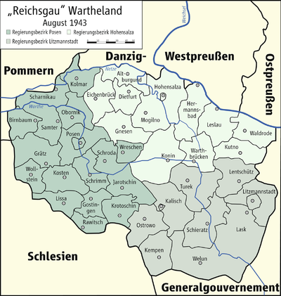
The district of Scharnikau (Wartheland) existed between 1939 and 1945 in the Reichsgauen Posen and Wartheland in Poland occupied by the German Empire . On January 1, 1945, the district comprised two cities and 58 municipalities.
Administrative history
prehistory
After the Versailles Treaty came into force on January 10, 1920, the Prussian districts of Czarnikau and Filehne south of the networks belonged to the Polish state as Czarnków and Wieleń , with the Polish parts of the districts being merged to form the powiat czarnkowski. To the north of the Netze, the remnants of the district that remained German had been administered jointly since August 2, 1919 and later became part of the new Netzekreis in the province of Grenzmark Posen-West Prussia .
Second World War (German occupation)
November 26, 1939, the Polish district Czarnków under the name was County Czarnikau part of the newly formed Reichsgau Poznan - later Wartheland - in the new government district of Posen . There is also evidence of a “wild” local renaming to “Netzeburg”. Later "Scharnikau" became common and since May 21, 1941 Scharnikau (Wartheland) was the official district name.
In the spring of 1945, the district was occupied by the Red Army and then became part of Poland again .
politics
Land Commissioner
- 1939 : Jochen-Hilmar von Wuthenau (1887–1965)
District administrators
- 1939–1940: Jochen-Hilmar von Wuthenau ( substitute )
- 1940–1943: Heidrich
- 1943 : Mell ( substitute )
- 1944–1945:?
Local constitution
After the annexation by the German Reich , only the town of Scharnikau (Wartheland) was granted the German municipal code of January 30, 1935 valid in the old Reich . The city of Filehne and the other communities were grouped together in administrative districts ; There were no more manor districts.
Place names
By unpublished decree of December 29, 1939, the German place names valid until 1918 were provisionally valid with regard to the previously Polish place names. This global renaming was possible because the entire German map series for the areas ceded to Poland in 1920 (also) continued to use the earlier German place names.
In the course of the next few years, place names were sometimes “wildly” Germanized, mostly at district level. In 1943, by order of the Reich Governor, with the consent of the Reich Minister of the Interior, all names relating to places that had a post or train station were finally determined in a German form. Since mostly "not German enough", these were phonetic adjustments, translations or free inventions, for example:
- Briesen: Hohenbriesen,
- Guhren: Netzguhren,
- Kruschewo: Kruschendorf,
- Milkowo: Milkau (Kr.Scharnikau, Wartheland),
- Mlynkowo: Mühlingen,
- Polajewo: Güldenau (Kr.Scharnikau, Wartheland),
- Pripkowo: Pripkow,
- Rosko: Roskau,
- Walkowitz: Walkenschleuse.
Web links
- District of Scharnikau (Wartheland) Administrative history and the district administrators on the website territorial.de (Rolf Jehke), as of August 19, 2013.
- Michael Rademacher: German administrative history from the unification of the empire in 1871 to the reunification in 1990. pos_czarnikau.html. (Online material for the dissertation, Osnabrück 2006).
- Michael Rademacher: German administrative history from the unification of the empire in 1871 to the reunification in 1990. pos_filehne.html. (Online material for the dissertation, Osnabrück 2006).