Ostrowo district

Ostrowo district was the name of a German administrative unit in occupied Poland (1939–45) during World War II .
Prehistory (1815 to 1919)
The area around the western Polish city of Ostrów Wielkopolski belonged to the Prussian province of Posen as the Adelnau district from 1815 to 1887 , and in 1887 the eastern half of the district was separated and formed into a separate Ostrowo district . On November 7, 1918, the majority of the Polish population rose against German rule and on November 10, 1918, the city was declared an autonomous Republika Ostrowska . In the course of the Wielkopolska Uprising , Ostrów Wielkopolski finally came under Polish control on December 31, 1918 and was officially ceded to the newly founded Poland on June 28, 1919 with the signing of the Versailles Treaty .
Administrative history
At the beginning of the Second World War , German troops occupied the western Polish powiat Ostrów Wielkopolski , the district town of Ostrów Wielkopolski was captured on September 4, 1939.
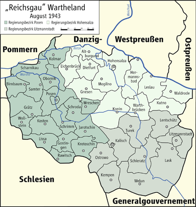
On October 26, 1939, the powiat was annexed to the German Reich under the name Ostrowo District , which, as a unilateral act of violence, was ineffective under international law. The district became part of the administrative district Kalisch (from 1941: administrative district Litzmannstadt) in the Reichsgau Wartheland .
The seat of the German district office was the district town of Ostrowo .
The German occupation ended with the invasion of the Red Army in January 1945.
politics
Land Commissioner
- 1939 : Büttner
District administrators
- 1939–1941: Büttner ( provisional )
- 1941–1945: Otto Lehmann
Municipal structure
The 134 localities in the district were initially grouped into 14 administrative districts . On April 1, 1941, the district of Ostrowo-Stadt was named a city according to the German municipal code of 1935. Towards the end of the occupation, the district consisted of 1 city ( Ostrowo ) and 13 administrative districts.
expansion
The district of Ostrowo had an area of 1044 km².
population
The Ostrowo district had in 1941: 108,727 mostly Polish inhabitants. The German occupation authorities drove over 9,800 Poles from the area between December 1, 1939 and December 31, 1943.
A small German minority lived in the area, and Germans were also settled during the occupation. Towards the end of the occupation, most of them left the area.
The Jewish population was deported to the General Government and murdered there.
Place names
The local occupation authorities gave all localities in the district with German names, although officially according to the unpublished decree of the Interior Minister of December 29, 1939, the German names valid from 1918 should initially continue to apply. On May 18, 1943, German names were set for all places with a post or train station in Wartheland , although there were again deviations.
List of cities and administrative districts in the Ostrowo district:
| Polish name | German name (1918) | German name (1939-1945) |
|---|---|---|
| Biniev | Biniev |
1939–1943 Biningen 1943–1945 Biening |
| Chojnik | honey | honey |
| Cieszyn | Teschen | Teschen |
| Czarnylas | Black Forest | Black Forest |
| Czekanów | Czekanow |
1939–1943 Scheckenau 1943–1945 Schackenau |
| Daniszyn | Danishin | Dieterslinde |
| Mikstat | Mixstadt | Mixstadt |
| Nowe Skalmierzyce | New scaling protection |
1939–1943 Neu Skalden 1943–1945 Kalmen |
| Odolanów | Adelnau | Adelnau |
| Ostrów Wielkopolski | Ostrowo | Ostrowo |
| Przygodzice | Great Przygodzice | Deer pond |
| Raszków | Rashkov | Raschkau |
| Wysocko Wielkie | Great Wysocko | Groß Hochkirch |
Web links
- Ostrowo district administrative history and the district administrators on the website territorial.de (Rolf Jehke), as of August 18, 2013.