District of Warthbrücken

Warthbrücken district was the name of a German administrative unit in occupied Poland (1939–45) during the Second World War .
Prehistory (1793 to 1807)
After the Second Partition of Poland from 1793 to 1807, the area around the western Polish city of Koło belonged temporarily to the Konin district in the Prussian province of South Prussia .
Administrative history
At the beginning of the Second World War , German troops occupied the western Polish powiat Koło , the district town of Koło was taken on September 18, 1939.
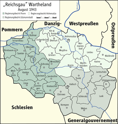
On October 26, 1939, the Powiat was attached to the German Reich under the name of Landkreis Wartbrücken (from May 21, 1941: Landkreis Warthbrücken ) , which as a unilateral act of violence was ineffective under international law. The district became part of the administrative district Hohensalza in the Reichsgau Wartheland .
The seat of the German District Office was the district town of Koło .
The German occupation ended with the invasion of the Red Army in January 1945.
politics
Land Commissioner
- 1939 :?
District administrators
- 1939–1940:?
- 1940–1945: Walter Becht
Municipal structure
The district of Warthbrücken was divided into two municipalities ( Koło and Kłodawa ), the remaining localities were initially divided into 12 and from April 1, 1943 into 10 districts .
size
The district of Warthbrücken had an area of 1097 km².
population
The Powiat Koło had 119,400 inhabitants in 1931, the district of Warthbrücken then only 107,964 inhabitants in 1941, immediately after the end of the occupation on February 1, 1945, 89,220 inhabitants were counted.
The German occupation authorities expelled over 14,000 Poles from the area between December 1, 1939 and December 31, 1943.
The Jewish population of the powiat numbered over 8,500 before the occupation (about 8% of the total population). When the war began, some fled from the Germans inland, the remaining Jews were initially concentrated in ghettos in Dąbie and Izbica Kujawska . In December 1941, the German occupation authorities set up the very first extermination camp ( Chełmno ) in the district , in which they murdered the majority of the Jewish population of the Wartheland .
Since the beginning of the 19th century a small German minority lived in the Powiat area , which before the occupation numbered over 6000 people (about 5% of the total population), their center was the city of Dąbie . During the occupation, Germans were also settled. After the end of the occupation, 8476 Germans (around 10% of the remaining population) were counted on February 1, 1945, the majority of them subsequently left the area.
Place names
As early as the end of 1939, the local occupation authorities gave all locations unauthorized German names, mostly verbal adjustments, translations or free inventions. On May 18, 1943, all places in the Wartheland with a post or train station were officially given German names, although there were some deviations.
List of cities and administrative districts in the district of Warthbrücken:
| Polish name | German name (1939-1945) | Polish name | German name (1939-1945) |
|---|---|---|---|
| Babiak | 1939–1943 Waldau 1943–1945 Babenwald |
Kłodawa | Tonningen |
| Chełmno nad Nerem | Kulmhof | Koło |
1939–1941 Wartbrücken 1941–1945 Warthbrücken |
| Czołowo | Star Valley | Kościelec | Church Village |
| Dąbie | Eichstädt | Krzykosy | Grünwald |
| Drzewce | Rodau | Sompolno | Deutscheneck |
| Izbica Kujawska | Mill Valley | Stary Budzislaw | Ehrenfeld |
| Karszew | Karschin |
Web links
- District Warthbrücken Administrative history and the district administrators on the website territorial.de (Rolf Jehke), as of August 19, 2013.