
Landsberger Strasse (Munich)
| Landsberger Strasse | |
|---|---|
|
|
|
 |
|
| Augustiner-Bräu on Landsberger Strasse | |
| Basic data | |
| State capital | Munich |
| Townships | Schwanthalerhöhe , Laim , Pasing-Obermenzing |
| Hist. Names | Salt road; Münchner Straße (in the area of the former municipality of Pasing) |
| Name received | 1878 |
| Connecting roads | Bayerstrasse , Bodenseestrasse |
| Cross streets | Grasserstraße, Holzapfelstraße, Max-Friedlaender-Bogen, Schrenkstraße, Fäustlestraße, Philipp-Loewenfeld-Straße, Bergmannstraße , Trappentreustraße , Donnersbergerbrücke , Astallerstraße, Barthstraße, Friedrich-von-Pauli-Straße, Anton-Hammel-Straße, Elsenheimerstraße, Friedenheimer Brücke , Mitterhoferstraße , Friedenheimer Strasse, Behamstrasse, Sandrartstrasse, Fürstenrieder Strasse , Wotanstrasse, Lutzstrasse, Rapotostrasse, Von-der-Pfordten-Strasse, Stöberlstrasse, Agricolastrasse, Willibaldstrasse, Kremser Strasse, Atterseestrasse, Am Knie, Josef-Felder-Strasse, Calderonweg, Georg-Habel -Straße, Offenbachstraße, Rathausgasse, Bäckerstraße, Gleichmannstraße |
| Places | Pasinger Marienplatz |
| Numbering system | Orientation numbering |
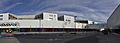
| Buildings | Augustiner-Bräu , Central Tower Munich , Main Customs Office (Munich) , Villa Kürth, Town Hall (Pasing) , Pasing Arcaden 2 |
| use | |
| User groups | Pedestrian traffic , bicycle traffic , individual traffic , public transport |
| Technical specifications | |
| Street length | 6.6 km |
The Landsberger road is one of the main arterial roads in Munich .
course
The street with a length of 6565 meters leads in the extension of Bayerstraße south parallel to the railway body of the railway line Munich-Hauptbahnhof-Munich-Pasing-Augsburg from the confluence of Martin-Greif-Straße through the Munich districts Schwanthalerhöhe (Westend), Laim and Pasing to Pasinger Marienplatz . At its eastern end, the road overcomes the small Theresienhöhe ridge , an extension of the western high bank of the Isar high bank . Its continuation to the west is the Bodenseestraße . From its intersection with the Mittlerer Ring on Trappentreustraße / Donnersbergerbrücke , it forms a section of Bundesstraße 2 to the west . At the level of the Laim S-Bahn station , Wotanstraße coming from the north through the Laim underpass and Fürstenrieder Straße going south (both parts of the so-called Outer Ring ) are crossed. In the center of Pasing, however, the B2 continues further north via the Pasing northern bypass on Josef-Felder-Straße . From the eastern beginning of the street to Elsenheimerstraße and from Am Knie to the center of Pasing, the tram runs in Landsberger Straße.
The street crosses two railway lines, namely the Munich Südring with an underpass and the Sendlinger Spange with a road bridge.
designation
The name of the street comes from the town of Landsberg am Lech , which is reached in the further course of the street.
Important structures on the road
The premises of the Augustiner Brewery (No. 31–35), the Central Tower Munich , the former main customs office (No. 122–132), the Persil School (No. 150), the ICE Hall of the Deutsche Bahn (No. 158), a hall of Jehovah's Witnesses, the Villa Kürth near the Laimer underpass, the Pasing town hall and the Pasing Arcaden 2.
At the corner of Elsenheimerstrasse there is a sculpture by Reinhart R. Wolke as well as the "gray men sculptures" by Christel Lechner .
Disused structures
- Building JRO publishing house (no. 191)
- Friedrich Wamsler's cooker factory (demolished in 1999)
- Großwirt Laim, large restaurant on the Laimer underpass (demolished in 1959, south wing 2019)
- Munich branch of Steinway & Sons (formerly Pianohaus Lang) (No. 336),

Landsberger Strasse at the former main customs office (the street to the left of the building complex)
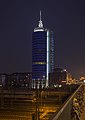
Central Tower Munich

Pasing town hall
Pasing arcades


literature
- Hans Dollinger : The Munich street names. 6th edition, Südwest Verlag, Munich 2007, ISBN 978-3-517-08370-4 , p. 180.
Individual evidence
Web links
Coordinates: 48 ° 8 ′ 23 ″ N , 11 ° 32 ′ 21 ″ E