
Bergmannstrasse (Munich)
| Bergmannstrasse | |
|---|---|
|
|
|
 |
|
| Apartment block Bergmannstrasse 27–33 | |
| Basic data | |
| State capital | Munich |
| City district, part of town | Schwanthalerhöhe , Westend |
| Hist. Names | Sendlinger way |
| Name received | 1883 |
| Cross streets | Landsberger Strasse , Westendstrasse, Tulbeckstrasse , Gollierstrasse, Kazmairstrasse, Heimeranstrasse, Anglerstrasse, Ridlerstrasse |
| Places | Gollierplatz |
| Numbering system | Orientation numbering |
| Buildings | Single home in Munich , elementary school on Bergmannstrasse |
| use | |
| User groups | Pedestrian traffic , bicycle traffic , car traffic |
| Technical specifications | |
| Street length | 850 m |
The Bergmannstraße is a street in Munich and is located west of downtown. It leads from Landsberger Strasse in the north to Ridlerstrasse in the south and is located in the Schwanthalerhöhe district . The street, previously known as Sendlinger Weg , was named in 1883 after the lawyer, historian and archivist Michael Adam von Bergmann (1733–1783), who was mayor of Munich from 1762 and then mayor.
location
Bergmannstraße is located in the Schwanthalerhöhe district and here in the Westend district, a classic working-class district with cooperative buildings from around 1900. With around 30,000 inhabitants on an area of just over two square kilometers, the district is one of the most densely populated districts in Munich. At 34.5% (as of 2015), the proportion of foreigners is one of the highest in the city. The rents here are on a medium level compared to the other Munich districts.
Bergmannstraße is centrally located in the city district and runs in a north-south direction for a length of almost 900 meters. The western parallel road, along with Trappentreustraße , is part of the Mittlerer Ring , which, however, runs mostly underground through the Trappentreutunnel . The multi-track railway line runs north of Bergmannstrasse from the main train station , which is about 1.5 kilometers to the east, and south of Bergmannstrasse the tracks of the Munich Südring run from it towards Ostbahnhof and from there on towards Rosenheim and Salzburg . The Theresienwiese , where the Munich Oktoberfest takes place every year , is about 800 meters east of Bergmannstraße.
Course of the road
Bergmannstrasse branches off south of Landsberger Strasse, a major arterial road that runs parallel to the Munich - Augsburg railway line , connects the city center with the western parts of the city and continues in the direction of Landsberg am Lech .
The northern part of Bergmannstrasse is characterized by mostly simple four to five-story apartment buildings and individual small businesses. In the middle part of the street on the western side with the Gollierplatz there is a green area of around 10,000 square meters. On the east side of the street is a listed multi-storey residential complex from the early 1920s. South of this is the single home in Munich , which was built as a raw brick building in the New Objectivity style under the direction of the Lower Franconian architect Theodor Fischer between 1925 and 1927. On the west side of the street, directly south of Gollierplatz, is the elementary school building , which was built between 1889 and 1891 in the neo-renaissance style (today a primary school). A little further to the south is a three-winged building complex around a forecourt, built in functional shapes with a slightly Expressionist touch between 1928 and 1931 and also known as the Green Block due to the light green paintwork .
Further south on the east side of the street is a post office from 1926 to 1928 in the New Objectivity style. At the southern end of Bergmannstrasse there are several apartment buildings from the years 1898 to 1909 on the west side, built in the neo-baroque or art nouveau style .
At its southern end, Bergmannstrasse meets Ridlerstrasse, which runs parallel to the Südring railway line, which runs from the main station to the east station.
history
As long as Neuhausen was not a separate parish, Sendlinger Weg was also a Kirchweg , as baptisms, weddings and festive services took place in the Sendlinger parish church of St. Margaret . It was not until 1871 that the Winthirkirche became a vicariate church and finally in 1882 a parish church. The paved field path ran like today's Donnersbergerstraße , led slightly to the east at the level of the current Richelstraße , crossed the railroad tracks at the level of Maillingerstraße and then continued on the later Bergmannstraße to the old Sendlinger church. In the extension of today's Maillingerstraße, Bergmannstraße was also located on the extended Burgfriedens border from 1846 to 1852. Since today's Bergmannstraße was on the municipal boundary of Neuhausen and Sendling, paving duty was still levied there in 1865 , for example when a wedding party wanted to cross the border. In 1877 the municipality of Sendling was incorporated , as a result of which the Feldweg came under Munich's urban planning sovereignty. After Haderer Weg was renamed Westendstraße in the course of incorporation, Bergmannstraße was named in 1883.
Map of Untersendling and Theresienwiese from 1812

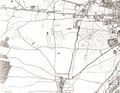
Original position sheet 1856
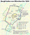
Map of the truce of Munich, green line 1846 to 1852

Plan of the koenigl. Main and royal seat of Munich, 1858/59 by Gustav Wenng


cartography
In the 14th edition of the Brockhaus Konversations-Lexikons from 1891, the street is completely marked and also built up up to the miner's school .
Transport links
The only direct connection from Bergmannstraße to local public transport is the Bergmannstraße stop of bus line 53 ( Münchner Freiheit - Aidenbachstraße ), which runs through Kazmairstraße, a cross street off Bergmannstraße.
The nearest underground stations are around 400 meters away, these are the Schwanthalerhöhe and Heimeranplatz stations , the latter station is also connected to the S-Bahn network.
Architectural monuments
Ten monuments erected between 1889 and 1927 are located directly on Bergmannstrasse in the youth or neo-baroque style or in the style of the New Objectivity. Bergmannstrasse crosses the Gollierplatz ensemble (E-1-62-000-19). Nos. 56, 58, 62, 64 and 66 at the south-western end of Bergmannstrasse form a coherent, handsome, but not uniform group of buildings.

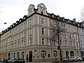
No. 35: Single home , built by Theodor Fischer in 1925/27 .

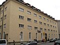
No. 36: Elementary school, built in 1889/91 by Friedrich Löwel and Carl Hocheder .
No. 47: Post office, built in 1925/26 by Franz Holzhammer , Robert Vorhoelzer and Walther Schmidt .
No. 66: Neo-Baroque corner building on Ridlerstrasse, built by Anton Wörz from 1898–99


The so-called Nymphenbrunnen by Elmar Dietz from the 1930s stands on Bergmannstrasse on Gollierplatz .
Other notable houses
- The single home in Munich is located in Bergmannstrasse 35, next to the single home in Hamburg, Europe's last home of its kind.
- The "Bergmannschule" (Bergmannstrasse 36):
- Georg Kerschensteiner opened the first of his auxiliary school classes in Munich in a barrack in the courtyard of the miners' school. From autumn 1902, Rupert Egenberger taught children with various disabilities there on his behalf .
- During the Second World War, the school was a barracks that housed four student companies . In the 2nd student company of medical students, Hans Scholl , Alexander Schmorell and Willi Graf, well-known members of the White Rose resistance group, had to do their military service.
- From January 22 to April 24, 1945, the building was a satellite or sub-camp of the Dachau concentration camp , in which male prisoners had to provide services.
- The Evangelical Migration Center in Munich is located in Bergmannstrasse 46 (“Greek House”).
- The Stragula cabaret is operated in Bergmannstrasse 66 .
literature
- City of Munich, KulturGeschichtsPfad 8: Schwanthalerhöhe ( PDF file )
Web links
Individual evidence
- ^ Rambaldi: Munich street names and their explanation. , P. 43
- ↑ Statistisches Taschenbuch 2016 , www.muenchen.de, accessed on February 23, 2017
- ↑ rent index Munich 2017 , www.wohnungsboerse.net, accessed on 22 February 2017
- ↑ See detailed border descriptions: Königlich Bayerischer Polizey-Anzeiger von München: 1836, p. 200
- ↑ Sendling 1853 (jpg file on www.bayerische-landesbibliothek-online.de)
- ^ Circle of Friends of Old Munich, Beautiful old Munich , 1965, p. 74
- ↑ KulturGeschichtsPfad 8: Schwanthalerhöhe, p. 10
- ↑ Munich city map, lithograph 1891 on machinatemporis.de
- ↑ City portal Munich: Architectural monuments - Bergmannstrasse
- ↑ Single home at www.muenchenwiki.de
- ↑ The dark side of history at www.schwanthalerhoehe.eu
- ↑ Evangelical Migration Center Munich at www.evangelisches-migrationszentrum.de
Coordinates: 48 ° 8 ′ 12 ″ N , 11 ° 32 ′ 14 ″ E