
Gutenbach (Black Cooker)
|
Gutenbach section name sequence : Wolfertsbach → Langertbach → Gutenbach |
||
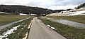
.JPG) The Gutenbach at the hiking car park in Spitztal in Oberkochen |
||
| Data | ||
| Water code | DE : 23861122 | |
| location |
Albuch and Härtsfeld
|
|
| River system | Rhine | |
| Drain over | Schwarzer Kocher → Kocher → Neckar → Rhine → North Sea | |
| source | a famine well in Wolfertstal 48 ° 48 '11 " N , 10 ° 5' 30" E |
|
| Source height | 526 m above sea level NHN | |
| muzzle | in Oberkochen in the Mühlkanal to the left of the Schwarzen Kocher Coordinates: 48 ° 47 '5 " N , 10 ° 6' 41" E 48 ° 47 '5 " N , 10 ° 6' 41" E |
|
| Mouth height | approx. 486 m above sea level NHN | |
| Height difference | approx. 40 m | |
| Bottom slope | approx. 13 ‰ | |
| length | 3.1 km from Hungerbrunnen | |
| Catchment area | 12.315 km² | |
The Gutenbach , also called Langertbach and Wolfertsbach , is a left tributary of the Schwarzen Kocher in Oberkochen in the Ostalbkreis in Baden-Württemberg .
Surname
The Gutenbach has three section names. In Wolfertstal it is first called Wolfertsbach , then from the inflow from the Langertbrunnen on the northern edge of Oberkochen together with its short source Langertbach to Katzenbachstraße in the village and only from there to Gutenbach .
geography
Gutenbach springs
Good source of Bach's three karst springs in located in a right-hander in the north to the Volkmarsberg laying Wolfertstal . All pour out of the shallow karst in the transition area between the Oxford limestone and the Oxford marl. All sources of the Gutenbach are on the Oberkochen route of the Karstquellenweg .
Famine well
The official source of the Gutenbach is a - also so-called - hunger well almost at the northernmost point of the curved valley center line a little east of the Lothringer Kreuz at about 526 m above sea level. NHN . It only pours after the snow has melted and when there is high rainfall . At the beginning of the stream bed, water then gathers from several sides and gushes from several springs in the middle of the meadow. The hunger well was greatly changed by the earth filling and the water supply pipes running here .
The Wolfertstal is a dry valley above the first spring . However, after heavy rainfall and after the snowmelt from the area of the Eichertbrünnel, located above the Hungerbrunnen on the way to Essingen , considerable amounts of surface water flow in two streams to the left and right of the way to the Hungerbrunnen.
New well
The at about 518 m above sea level. New wells lying above sea level ⊙ in Wolfertstal is a constant source that pours about 4 l / s. It is less than 200 meters from Oberkochen's first house on a geological fault ; The offset of water-bearing limestone layers against damming marl results in underground water accumulation with spring discharge. The flowing stream of the previously open well now runs sideways into the Gutenbach.
Langertbrunnen
The Langertbrunnen ⊙ is the largest source of the Gutenbach. It is located at about 529 m above sea level. NN . After a short run, the water flows from the left foot of the valley slope on the northern edge of Oberkochen into the Gutenbach. The Langertbrunnen lies on the boundary between the Weißjura Alpha and the water-permeable beta limestone on top. The spring dries up when the groundwater level is low . Its catchment area is the Langert , a wooded plateau that largely belongs to Aalen from the cut of the Wolfert Valley northwards to the Albtrauf.
At this spring, which was taken on a private initiative in the 1980s, there is a water playground with a water treading facility . The Langertbrunnen is also called the battle source.
course
After it has been fed from the Langertbrunnen, the Gutenbach first flows in a southerly direction. It passes the Luggenlohbrunnen , a source for the drinking water supply at 508 m above sea level. NHN at the right foot of the slope. With up to 450,000 m³ per year, the Luggenlohbrunnen supplies half of Oberkochen's drinking water requirements.
Then he changes to the southeast run and runs through a park along Walther-Bauerfeldstrasse. From just outside the Aalener road the rest of his underflow is underground verdolt . After a total of 3.1 km from the Hunger Well, where the two stove arms unite in front of the CD Wälzholz company , it flows from an underground channel with a rectangular profile into the black stove .

In the hunger well, the water gushes out of the meadow in various places
After the snowmelt, two streams flow from the Eichertbrünnele to the Hungerbrunnen

Gutenbach directly below the hunger well

At the new well

Langertbrunnen (source)
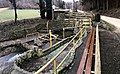
Langertbrunnen (water treading facility)

Langertbrunnen (complete system)

The Langertbach flows into the Gutenbach coming from the left

Luggenloh fountain

Mouth from a square tunnel into the Black Kocher flowing towards the viewer, whose two channels coming from the left unite here


.JPG)


See also
Individual evidence
LUBW
Official online waterway map with a suitable section and the layers used here: Course and catchment area of the Gutenbach
General introduction without default settings and layers: State Institute for the Environment Baden-Württemberg (LUBW) ( notes )
- ↑ Height according to black lettering on the background layer topographic map .
- ↑ a b Height according to the contour line image on the topographic map background layer .
- ↑ Length according to the waterway network layer ( AWGN ) .
- ↑ Length measured on the background layer topographic map .
- ↑ Catchment area according to the basic catchment area layer (AWGN) .
- ↑ Section names after the layer water body name .
Other evidence
- ↑ Hansjörg Dongus : Geographical land survey: The natural spatial units on sheet 171 Göppingen. Federal Institute for Regional Studies, Bad Godesberg 1961. → Online map (PDF; 4.3 MB)
- ↑ Information board of the Karstquellenweg
literature
- Topographic map 1: 25,000 Baden-Württemberg, as single sheet No. 7126 Aalen and No. 7226 Oberkochen
- Geological map 1: 25,000 of Baden-Württemberg, sheet No. 7126 Aalen with explanatory booklet. Published by the Geological State Office and the State Surveying Office Baden-Württemberg, Stuttgart 1980
Web links
- Map of the course and catchment area of the Gutenbach on: State Institute for the Environment Baden-Württemberg (LUBW) ( information )
- Map of the course and catchment area of the Gutenbach on: Geoportal Baden-Württemberg ( information )
- Hunger wells in Wolfertstal on oberkochen.de
- Measuring table sheets in the Deutsche Fotothek :
- 7126 Aalen from 1934
- 7226 Oberkochen from 1904
- Neubrunnen on oberkochen.de
- Langertbrunnen on oberkochen.de
- Luggenlohbrunnen on oberkochen.de