Volkmarsberg
| Volkmarsberg | ||
|---|---|---|
|
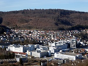
Volkmarsberg with the observation tower above Oberkochen , in the foreground the Zeiss company |
||
| height | 743.6 m above sea level NHN | |
| location | Baden-Wuerttemberg , Germany | |
| Mountains | Swabian Alb | |
| Coordinates | 48 ° 47 '32 " N , 10 ° 5' 11" E | |
|
|
||
| particularities | Volkmarsbergturm ( AT ) | |
The Volkmarsberg is in Ostalbkreis situated 743.6 meters above sea level. NHN high mountain in the Swabian Alb . It is the local mountain of the city of Oberkochen .
geography
The Volkmarsberg rises west of the town of Oberkochen im Albuch , a northeastern part of the Swabian Alb west of the Kocher - Brenz Valley .
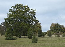
The mountain top, which is up to over 743 m above sea level. NHN rises, consists of mass limestone of the White Jura with layers of Malm epsilon and zeta 1. The juniper heather on the plateau is an earlier sheep pasture, which was partially recaptured by the forest. It has been under nature protection since 1928. The unwooded part of the nature reserve presents itself today as a park-like juniper heather, which is animated by old beeches , oaks and linden trees .
Numerous hiking trails lead to the Volkmarsberg, on the summit of which there is a 23 meter high observation tower. The 365 kilometer long Swabian Alb Northern Edge Trail of the Swabian Alb Association leads from Donauwörth over the Volkmarsberg to Tuttlingen , following the Alb eaves . A section of the Way of St. James also leads from Neresheim over the Volkmarsberg to Rottenburg am Neckar and on to Santiago de Compostela, 2,400 kilometers from Oberkochen .
origin of the name
The origin of the name is not known with certainty. It is said to have been called "Völkerberg" in old documents and its current name comes from the 18th century. Another explanation is that the name of the mountain was originally "Volkhartsberg", which means something like folk forest or community forest, i.e. a mountain whose forest area was owned by the community. However, “hard” can also stand for mountain pasture or willow forest (forest pasture). This could explain how the mountain got its name, although it was completely unforested for a long time, at least in the first half of the 19th century.
history
First Volkmarsberg Tower (1890)
In 1890 the Royal Statistical Office built an 11 meter high wooden tower on the summit plateau of the Volkmarsberg for measurement and orientation purposes. In 1897, the Swabian Alb Association , which had had a local branch in Oberkochen since 1891, took over the tower and expanded it into a 16-meter-high observation tower.
In 1903 the Swabian Alb Association laid out the zigzag path to the Volkmarsberg, which still exists today, with a length of 810 meters and a gradient of between 7 and 10%.
The wooden tower had to be closed in 1905 because it was dilapidated. Before a decision could be made about demolition and a new building, it fell victim to an autumn storm in 1911. Plans for a new building were not implemented until almost two decades later.
First Albverein refuge (1924)
In 1924 a 9.5 meter long and 6 meter wide Albverein refuge with a covered canopy was inaugurated. The hut was not managed.
Second Volkmarsberg Tower (1930)
On May 25, 1930, after a ten-month construction period, today's Volkmarsberg tower was inaugurated. The 23 meter high reinforced concrete observation tower has a footprint of 7 × 7 meters, the platform measures 6 × 6 meters. The construction costs amounted to 31,200 Reichsmarks . The tower has five floors, eleven flights of stairs and 104 steps. It weighs 390 tons.
At the beginning of the 1930s, Emil Kopp from Oberkochen, also known as “Bergwirt” and “Diftele”, received permission to operate a kiosk with a basement as a mountain tavern, which no longer exists today. This occasionally led to conflicts with the Albverein.
In 1933, the voluntary labor service began building the 1365 meter long Volkmarsbergstrasse, which leads from the Dreißental on the left-hand slope of the forest with an incline of 10 to 12% to the juniper heather and ends about six hundred meters from the tower.
In 1938 the entire mountain top became a nature reserve according to the provisions of the Reich Nature Conservation Act of 1935.
During the Second World War , the Volkmarsbergturm served as an observation station for the flak . After the end of the war, the summit, including the tower and hut, was confiscated by the American occupying forces , fenced off and used as a military radio station until 1960.
"Holzahans" (1955)
Since the Albvereinshütte was in the American restricted area and was no longer accessible, Hans Holz from Oberkochen improvised in 1955 with folding tables and benches to cultivate the place where a ski practice slope created in the 1930s at 650 m above sea level. NHN meets the Volkmarsbergstrasse. In 1956 he was granted the right to “sell drinks and food on the Volkmarsberg site” by a municipal council resolution against payment of an annual rent of DM 200 . In the following years a "Volkmarsbergschänke" was created, which was popularly called "Holzahans". This was continuously expanded over the years until the management had to be given up in 1976 due to sanitary inadequacies.
Second Albverein refuge (1962)
It was not until 1960 that the Americans cleared the mountain. After the German Federal Armed Forces refrained from further military use, the tower and refuge were officially released in September 1961.
The Albverein refuge was meanwhile in a desolate condition, so that the local branch of the Albverein decided to demolish and rebuild. After a construction period of only six months, the new shelter, a flat roof building, was inaugurated in October 1962.
Ski lift (1973)
The ski practice slope at “Holzahans”, created in the 1930s, was considered one of the most snow-reliable areas in the region at the time. Therefore, the ski department of the then gymnastics club Oberkochen (TVO), since 1986 Turn- und Sportverein Oberkochen e. V. 1903 (TSVO), there in own contribution a ski lift. This drag lift had a capacity of six hundred skiers per hour. The inauguration took place after a year and a half of preparatory work on October 31, 1973.
Third Albverein refuge (1974)
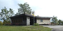
A few months after the kitchen was enlarged in October 1973 and a patio was added, the Albvereinshütte burned down completely on February 9, 1974 due to a technical defect in the drinks refrigerator. On November 29, 1974, the Swabian Alb Association completed what is now the refuge. On Ascension Day 1975, it was officially inaugurated as part of a star hike.
In 1980 the Volkmarsberg tower was renovated for around 80,000 German marks on its fiftieth birthday. It received new windows and a copper roof, and the tower room was redesigned as a room for the youth group.
Federal President Karl Carstens visited the Volkmarsberg on April 25, 1981 as part of his hiking tour across Germany.
TSVO ski hut (1982)
After the management of the "Holzahans" was given up in 1976 due to sanitary inadequacies, the ski department of the then Gymnastics Club Oberkochen (TVO), since 1986 Turn- und Sportverein Oberkochen e. V. 1903 (TSVO), took over the hut and brought it into a condition that meets the legal requirements.
In 1982 the association tore down the former Holzahans hut and built today's TSVO ski hut.
Mother beech (2018)
The mother beech is a prominent point at 690 m above sea level. NHN at the foot of the heather area, which is shown in most hiking maps. It has been there since the beginning of the 20th century. The huge red beech was attacked by fungus after a hundred years and had to be secured with a steel cable for years. Since it continued to lose its stability and became a danger for visitors to the Volkmarsberg, it had to be felled in November 2018 in coordination with the nature conservation authority. The leftover tree stump dead wood, on which the tinder fungus has settled.
The mother beech should not be replaced as there are similar trees in the vicinity, one of which will develop into "mother beech two" over time.
Erlau Bank (2020)
A Eger -Bank at the foot of Volkmarsberg tower by the company RUD Ketten Rieger & Dietz had been donated, attracted 2,020 nuisance in January. Some criticized the bank because it showed a sexist depiction, while others criticized the criticism of the bank. According to a company spokesman, it is “a popular, proven and funny motif”, whose “obvious ambiguity is to document the multi-dimensionality of the product”. In mid-February, the hut warden moved the bank to a less exposed place behind the Albverein refuge.
use
On the summit plateau there is a managed hut of the Swabian Alb Association as well as the 23 m high Volkmarsbergturm, which also belongs to the Alb Association. From the tower you have a wide view of the entire Eastern Alb. In inversion weather conditions, in rare cases the view extends to the Zugspitze 180 kilometers away .
The Volkmarsberg tower now houses the amateur radio relay with the callsign DB0AA .
A little below on the left of the road to Volkmarsberg is a ski lift and a ski hut belonging to TSV Oberkochen e. V. 1903.
Protected areas
The juniper heather on the hilltop was placed under nature protection under Württemberg law in 1928 . In 1938, the entire 70 hectare hilltop was designated as a nature reserve in accordance with the provisions of the Reich Nature Conservation Act of 1935. The protection purpose is the preservation of the juniper heather as a sheep pasture in connection with a varied tree population. Around half of the nature reserve is now a mixture of park forest and juniper heather, which requires constant maintenance due to the threat of bush encroachment.
The nature reserve (NSG) Volkmarsberg with an area of 68.1 hectares is part of the 4703 hectare FFH area No. 7226311 heaths and forests between Aalen and Heidenheim and the bird reserve No. 7226441 Albuch , which has a size of 8645 hectares .
On the hilltop there are numerous nesting mounds of the yellow meadow ant overgrown with grass and herbs .
Picture gallery
Yellow meadow ant nest mound on the hilltop
literature
- Alfons Mager: Volkmarsberg - Oberkochen's local mountain. A nature reserve. In: City of Oberkochen, Mayor Harald Gentsch (Ed.): Oberkochen - history, landscape, everyday life. Oberkochen 1986, pp. 323-334. Online at heimatverein-oberkochen.de.
Web links
- Profile of the nature reserve in the LUBW's list of protected areas
- Images on heimatverein-oberkochen.de:
- Local group Oberkochen of the Swabian Alb Association
- Information on the Volkmarsberg tower from the Swabian Alb Association
See also
Individual evidence
- ↑ Map services of the Federal Agency for Nature Conservation ( information )
- ↑ Hans-Joachim Bayer: On the geology of the Oberkochener area. In: City of Oberkochen, Mayor Harald Gentsch (Ed.): Oberkochen - history, landscape, everyday life. Oberkochen 1986, pp. 268-292, here: p. 275.
- ↑ Profile of the nature reserve in the LUBW's list of protected areas
- ↑ Location table Jakobsweg Neresheim - Rottenburg on jakobswege-europa.de.
- ^ Alfons Mager: Volkmarsberg - Oberkochen's local mountain. A nature reserve. In: City of Oberkochen, Mayor Harald Gentsch (Ed.): Oberkochen - history, landscape, everyday life. Oberkochen 1986, pp. 323–334, here: p. 323. Online at heimatverein-oberkochen.de.
- ↑ Dietrich Bantel: Volkmarsberg - Where does the name come from? on heimatverein-oberkochen.de.
- ↑ a b c d e f g h i j k l m The Volkmarsberg on albverein-oberkochen.de.
- ↑ Dietrich Bantel: The first hut on the Volkmarsberg on heimatverein-oberkochen.de.
- ^ Mager p. 327.
- ↑ Alfons Grupp - an old Oberkochen tells on heimatverein-oberkochen.de
- ↑ Pure Oberkochen - em Kies isch's g'wieß (Part 2) on heimatverein-oberkochen.de (with image of the Kopp'schen Bergschänke).
- ↑ a b Karl Schurr / Dietrich Bantel: The building history of the Volkmarsberg tower on heimatverein-oberkochen.de
- ↑ a b c Dietrich Bantel: From “Holzahans” to the ski hut on heimatverein-oberkochen.de .
- ↑ a b c d Wilfried Müller: The snow village of Oberkochen in olden times - Part 2 on heimatverein-oberkochen.de. According to this report, the management of Hans Holz was given up as early as 1975 and in the same year the ski department of the TVO "took over the lease and in 1977".
- ↑ The Volkmarsberg is again free to citizens and community on September 8 1961st
- ↑ In 2010 it was called "around a hundred years old": Mother beech is threatened with its end in citizens and communities on October 8, 2010.
- ↑ Mutterbuche am Volkmarsberg is liked in the online edition of the Schwäbische Post from November 16, 2018.
- ↑ Trouble about Bänkle am Volkmarsberg in the online edition of the Schwäbische Post from January 3, 2020.
- ^ Opinions are divided on this bank in the online edition of the Schwäbische Post from January 20, 2020.
- ↑ FM relay list DL 10m / 2m / 70cm on elschenbroich.com.
- ↑ Skihütte Oberkochen on skihuette-oberkochen.de.
- ↑ Mager p. 323 and 329
- ↑ Mager pp. 329-230.
- ↑ Dietrich Bantel: The “Hexafels” on albverein-oberkochen.de.


