
Laubegg (huts)
| Laubegg | ||
|---|---|---|
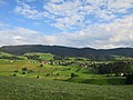
 The Laubegg from the east |
||
| height | 752 m above sea level M. | |
| location | Canton of Zurich , Switzerland | |
| Mountains | Zimmerberg | |
| Dominance | 1.21 km → Neuguet | |
| Notch height | 120 m ↓ Saturdayern | |
| Coordinates | 692 925 / 226745 | |
|
||
| Type | Molasses | |
| rock | Sedimentite | |

The Laubegg is a striking moraine hill of the Zimmerberg near the Hüttnersee in the canton of Zurich , Switzerland .
location

The hill rises between the villages of Schönenberg , Saturdayern and the Hüttnersee. It is part of the glacial area between Höhronen and Albis, rich in moraines and drumlins . It originated during the retreat of the Linth - glacier at the end of the Würm Ice Age (about 13,000 years BC..) And allowed the impoundment of a glacier lake - today's Hüttner lake. Especially the northeast flank against Saturdayern drops steeply by 120 meters. The terrain also drops steeply by 95 meters towards the basin of the Hüttnersee, while the hill on the southwest side towards the hamlet of Sägel drops only slightly.
The exposed position of the hill allows a distant view from Lindenberg via Albis , Lake Zurich , Säntis and Etzel to the Rinderweidhorn . In the southeast lie the Hüttnersee with the village of Hütten and the Höhronen, to which the Laubegg runs roughly parallel.
The municipal border between Richterswil and Wädenswil runs over the Laubegg .
history

The farm on the (Lower) Laubegg was mentioned in writing as early as 1278. At that time the fiefdom farmer Johannes Münch built the land. In the course of the Middle Ages, the Fraumünster Abbey and the Zurich Hospital, the Wettingen Monastery and the Barons of Wädenswil , and from 1287 their legal successor, the Johanniterkomturei Wädenswil , owned goods on the Laubegg. With the sale of the Wädenswil dominion by the Johanniterkomturei to the city of Zurich, the Laubegg became the fiefdom of the Wädenswil bailiff around 1550 .
Due to its exposed location, the hill was of strategic importance, especially in the early modern period , when the close territorial and denominational border between Reformed Zurich and Roman Catholic Central Switzerland with the Schwyz and Zug estates was of military importance. On one of the foothills of the Laubegg, Zurich built the Bellenschanze shortly before the First Villmerger War in 1656 and another ski jump on the Rundhöcker Wolfbühl (745 m above sea level ) not far from the Laubegg. These fortifications were part of a whole chain of entrenchments along the Schwyz and Zug borders. During the coalition wars, Austrian troops were encamped on the Laubegg in 1799 .
While the Untere Laubegg farm at the foot of the hill presents itself as a baroque ensemble, the Obere Laubegg on the crest of the hill has only recently been settled. The striking main building in Swiss wood style was built in 1900.
Settlements
Just below the top of the hill is the hamlet of Obere Laubegg on steep terrain . The Untere Laubegg lies at 713 m. ü. M. on a small terrace in the northwest. On the ridge , a road that runs the hamlet Sägel (m 745th ü. M.) in huts with the hamlet Seeli (m 670th ü. M.) connects near the lake Hüttner.
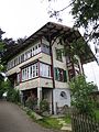
House in the Upper Laubegg in Swiss wood style on the steep west flank
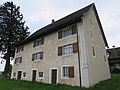
House in Unteren Laubegg (1777) with baroque architectural painting on the corners
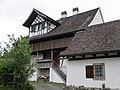
Half-timbered house in Untere Laubegg at the foot of the hill
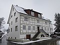
Half-timbered house in the hamlet of Seeli at the foot of the hill

The hamlet of Seeli with Höhronen in the morning light


gallery

View of the Hüttnersee from the west with Höhronen (left) and Laubegg (right)
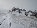
View from the street to Oberen Laubegg
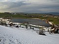
View from the south with Hüttnersee
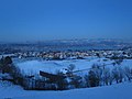
View of Saturdayern, Lake Zurich and the Alps
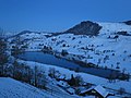
View of Hüttnersee, Rossberg and Etzel

View of Schönenberg and Lake Zurich
View from the highest point of huts and ceilings


literature
- E. Stauber: The Zurich ski jumps on the Swiss border , Wädenswil 1905.
- Peter Ziegler : Hütten , Wädenswil 1987.