
Limfjord
| Limfjord | ||
|---|---|---|
 |
||
| Connects waters | North Sea | |
| with water | Kattegat | |
| Separates land mass | Jutland | |
| of land mass | Vendsyssel-Thy | |
| Data | ||
| Geographical location | 56 ° 56 '34 " N , 9 ° 4' 30" E | |
|
||
| Coastal towns | Aalborg | |
| Islands | Mors , Fur , Venø , Jegindø | |

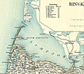
The Limfjord is an elongated sound between the Jutland peninsula and the island of Vendsyssel-Thy in Denmark . The 1500 km² large body of water connects the North Sea off Agger and Thyborøn in the west with the Kattegat off Hals in the east. The shoreline measures around 1000 km. The catchment area extends over 7500 km², which corresponds to about one sixth of the area of Denmark.
The eastern part between Aalborg and Hals is narrow and river-like for over 30 kilometers and is called Langerak , the western part is much wider. There are several islands there, including Mors , Fur , Venø and Jegindø . Larger peninsulas are Himmerland in the east and Salling and Thyholm in the west.
The name is derived from the Danish expression limsten for bryozoans - chalk so the biogenic limestone , which occurs (65 million years old) here in many places to light.
Cities and bridges
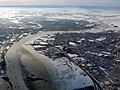
The largest city and most important port on the Limfjord is Aalborg . There is a railway - and with the Limfjordsbroen a road bridge to the north of the city, to Nørresundby . With the Limfjord tunnel, a motorway tunnel crosses the sound there. Other bridges in the Limfjord are the Oddesundbroen in Struer Kommune , the Vilsundbroen between Mors and Thy , the Sallingsundbroen near Nykøbing Mors and the Aggersundbroen near Løgstør from west to east .
Salinity and fishing
The headlands of Agger Tange and Harboøre Tange in the west were connected between 1100 and 1825. For 700 years the largest areas of the Limfjord were therefore far from the sea (the Kattegat ); due to rain and river water, its western and southern areas had brackish water .
The headland to the North Sea was destroyed by the February flood in 1825 . Since then, the so-called Thyborøn Canal has connected the Limfjord and the North Sea. The towns on the Limfjord benefited from the breakthrough to the North Sea because the sea trade offered new prospects. In contrast, the fishermen in the western part lost their brackish water fishing grounds, because as a result of the breakthrough, the salinity in the western Limfjord increased.
The salinity drops measurably in the direction of the side arms. It is 31.4 PSU (3.1%) in Nissum Bredning , and only 26.2 PSU (2.6%) in Skive Fjord near Skive . In comparison, the salinity of the northern North Sea reaches 3.5%. The local salinity can also be influenced by the prevailing wind directions, e.g. B. when low-salt surface water is pressed into bays and colder (and salty) deep water can flow up on the opposite bank.
Today the Limfjord is especially known for mussel fishing. Mussels are caught for the domestic market and for export. Of the 65 Danish licenses to fish for mussels, 51 relate to the Limfjord. In addition, the last Danish oyster beds can be found in the Limfjord , which is one of the northernmost occurrences in Europe. Water temperatures above 18 degrees at the bottom of the water are favorable; however, the often lower temperatures slow down growth and thus have a positive effect on the aroma.
In 2014 the Limfjord suffered more from a lack of oxygen than ever before. Around 30 percent of the water was affected. The main cause is the heavy input of nutrients from agriculture, but also the rise in sea temperature.
Cultural landscape
The Limfjord and the surrounding landscapes have inspired many artists. Among the writers are JP Jacobsen (1847–1885), Jeppe Aakjær (1866–1930), Johannes V. Jensen (1873–1950), Thøger Larsen (1875–1928), Johannes Buchholtz (1882–1940), Hans Kirk (1898–1962) and Aksel Sandemose (1899–1965).
technology
Two overhead lines run across the Limfjord ( Limfjord overhead line crossing 1 and Limfjord overhead line crossing 2 ).
Picture gallery
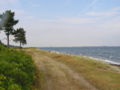
Odby Bugt

Oddesundbroen in the Struer municipality
The western part

Limfjordsbroen between Aalborg and Nørresundby
Aalborg in winter 2010


Web links
- Limfjord entry online lexicon Den Store Danske (Danish)
Individual evidence
- ↑ Basic analysis (PDF, Danish), from Naturstyrelsen, accessed on January 21, 2015.
- ↑ Ole Berthelsen: Geologi i Aalborgområdet. Råstoffer, fundering, vandindvinding , Copenhagen 1987. ISBN 87-421-0752-0 .
- ↑ PDF Aalborg University, 2012.
- ↑ Leaflet ( Memento of the original from January 21, 2015 in the Internet Archive ) Info: The archive link was inserted automatically and has not yet been checked. Please check the original and archive link according to the instructions and then remove this notice. Muslingeerhvervet, 2014.
- ↑ Magnus Bredsdorff: Værste iltsvind i 15 år: Nu dør selv muslingerne i Limfjorden Ingeniøren, July 30, 2014, accessed on February 14, 2015.