
List of architectural monuments in Forchheim
 Forchheim old town ensemble • City fortifications Monuments according to districts: Core city • Buckenhofen • Burk • Kersbach • Reuth • Serlbach • Sigritzau |
The monuments of the Upper Franconian district town Forchheim are compiled on this page . This table is a partial list of the list of architectural monuments in Bavaria . The basis is the Bavarian Monument List , which was first drawn up on the basis of the Bavarian Monument Protection Act of October 1, 1973 and has since been managed by the Bavarian State Office for Monument Preservation . The following information does not replace the legally binding information from the monument protection authority. This list reflects the update status from January 31, 2015 and contains 377 architectural monuments.
Ensembles
Forchheim old town ensemble

The ensemble ( location ) encompasses the city center of Forchheim within the early modern fortification in its areas that are still preserved in the historical structure. The old town clearly shows the different phases of urban growth as well as the uses and social stratifications of the quarters, remnants of the bastion fortifications have been preserved or their course can still be traced in the street layout. The episcopal castle and the early parish church of St. Martin form the core of the development . It is possible that under Karl Martell and Pippin the Younger (714–768) a royal court was established within today's old town . The stays of Franconian kings since the middle of the 9th century testify to the existence of a travel palace that flourished under Arnulf von Kärnten (887–899). It is unlikely that it was on the site of the later bishop's residence (probably west of the parish church). Decisive for Forchheim's further development up to 1802 is Heinrich II. Donation of the royal property to the diocese of Bamberg founded by him in 1007. Bishop Otto the Holy (1102–1139) built a new episcopal house and a Marienkapelle, the core of which still exists today. Around the parish church, which had been a collegiate monastery since 1354, the canons' courts were built in the 15th century, creating a separate spiritual district there. The castle and church with the surrounding, ring-shaped buildings are still clearly recognizable in the town plan. It is not known when Forchheim received city rights . In a document from 1310 it is referred to as civitas . A Jewish community is attested for 1289 in connection with a pogrom (after resettlement, the Jews were placed under episcopal protection in 1400, expelled in 1499, a Jewish community again existed in the middle of the 17th century, in 1763 the third largest in the bishopric of Bamberg ). Along the main street was built in the 12./13. In the 19th century, a planned city expansion as a new bourgeois center. To the north, the street widens to the old market square and the former egg market, which is the part now known as the main street, which leads north to Wiesent, and the square in front of the town hall, the former green market. The late medieval group of half-timbered houses with the town hall dominates . The secluded parish church of Sankt Martin rises behind it, and looks towering into the square. The main street, still known as the city in the 19th century, is characterized by the characteristic juxtaposition of closely lined half-timbered buildings, some of which are plastered, and sandstone buildings, with the gable predominating. To the south, it ends where the Paradeplatz begins today, at the place of the lost Nuremberg Gate (beggar tower). In this prominent location on the former main thoroughfare Bamberg - Nuremberg , inns and dealers with their shops could be found. The rear areas were also built over until the beginning of the 19th century, so that only a few open spaces and gardens remained. Smaller lanes branch off at right angles from the main street, in which there were craftsmen and farmers in less prominent locations . Around 1300 the area between Bischofsburg in the west, Hornschuchallee in the east, Katharinenspital in the north and Paradeplatz in the south was surrounded by a wall. The course of this city wall can still be seen in the partially curved street layout, for example on the northern Paradeplatz. Outside the walled city, suburbs developed from the 14th century, especially along the arterial road to the north and south. In the east in front of the city wall a predominantly arable area emerged, in the north a Scheunenviertel and along the Wiesent there were numerous mills. With the expansion of Forchheim into the southern state fortress of the Principality of Bamberg from the 16th century, these suburban areas were included in the bastionary fortification system. In this city area, which was enlarged by almost two thirds, the city center and the later extensions were still evident until the 19th century. A large part of the area surrounded by the bastions was not built over until the 19th century and was used as garden land. In the middle of the 17th century a Franciscan monastery (today the Redemptorist Monastery of St. Anton) was founded on the eastern edge of the city. A major baroque renovation was not carried out, probably also due to the narrow belt of the fortifications. The medieval system has largely been preserved in the city. The closed townscape is characterized by a large number of half-timbered buildings, some with a medieval core, and elegant baroque sandstone houses. From 1875 until after the First World War , the cityscape changed due to the gradual removal of the fortifications. During the Second World War , the old town of Forchheim was largely spared from bomb attacks. The old town is now a shopping center, the streets are partly pedestrianized, houses have been converted for commercial use. File number: E-4-74-126-8.
City fortifications
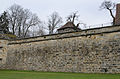
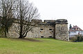
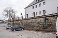
After the Markgräflerkrieg in 1552 Forchheim was expanded into a fortress. The fortifications were partially renewed and modernized after the Thirty Years War . The bastionary fortification ( location ) (file number D-4-74-126-3) consists of sloping walls made of sandstone hump blocks. Of which are received:
- St. Veit Bastion , inscribed “15 ..” (digits no longer legible) and “1793” ( location ), curtains south-east ( location ) then and north ( location ) to the bastion at Saltor, in front of the Mauerlücke district court. Inside there are two parallel barrel-vaulted casemates. In the inner corner of the obtuse-angled farces is a fountain, which was formerly accessible from both casemates.
- Bastion at the Saltorturm , 16./18. Century ( location ). Inside there are two parallel barrel-vaulted casemates and a fountain in the inner corner of the obtuse farces. The casemates are accessed via the Saltorturm.
- St. Valentini-Werk (Zwingerbastion), inscribed “1657” ( Lage ), south-west curtain wall to Sattlertorstrasse ( Lage ), northeast curtain wall up to the northern moated castle ( Lage ). Inside there is a clearing passage. The bastion bears the coats of arms of Prince-Bishop Philipp Valentin Voit von Rieneck , Provost Franz Conrad von Stadion and Cathedral Dean Georg Heinrich von Künsberg, labeled “1657” .
- Northern moated castle , fortified meadow throughflow, 16th century and inscribed "1784" ( location )
- St. Petri-Werk or Dernbach-Bastion , 1675 (marked “1664”), between Bamberger Straße and Friedensstraße ( Lage ), accessible inside through circular corridors; Coat of arms of Prince-Bishop Peter Philipp von Dernbach
- Dreikirchenbastion or Henrici-Werk , only the northeast flank preserved, 1660 north of Dreikirchenstrasse ( location )
- Three coat of arms of the Neuwerk bastion from the 17th century are located at the gymnasium Luitpoltstrasse 1
Anticlockwise views of the preserved fortress from the northeast:

St. Petri factory, field side, northeast corner

St. Petri factory, field side, wall along Andreas-Steinmetz-Straße

St. Petri factory, field side, wall on Bamberger Straße

Northern moated castle

St. Valentini plant, field side

St. Valentini factory, curtain wall at Sattlertorstrasse

Bastion at the Saltorturm, city side
Curtain at the Saltorturm, field side
St. Vitus Bastion, field side from the north

St. Veit bastion, field side, coat of arms stone

St. Vitus Bastion, field side from the southeast

Coat of arms stones Luitpoldstrasse 1
Bastion remnants on Klosterstrasse, from the north-west


| location | object | description | File no. | image |
|---|---|---|---|---|
| Sattlertorstraße 23 ( location ) |
Former guard house of the Sattlertor Vorwerk | Renewed two-storey saddle roof house, the core of the 18th century
Remains of the back wall of the Vorwerk |
D-4-74-126-260 |
 more pictures |
| Near Torstrasse ( location ) |
Nuremberg Gate | Large central gate with two side passages, rich, decorative facing on the field side, inscribed "1698" | D-4-74-126-271 |
 more pictures |
Remains of the city wall are still contained within the fortress.
| location | object | description | File no. | image |
|---|---|---|---|---|
| Kapellenstrasse 16 ( location ) |
Medieval city wall, section between Sattlertorstrasse and the hospital | 13./14. century | D-4-74-126-2 |
 more pictures |
| Sattlertorstraße 21 ( location ) |
Saltorturm | Three-story gate tower, 14th century and mid-16th century | D-4-74-126-239 |
 more pictures |
Architectural monuments according to districts
Forchheim
Within the Old Town ensemble
Apothekenstrasse
| location | object | description | File no. | image |
|---|---|---|---|---|
| Apothekenstrasse 1 ( location ) |
Residential building | Two-storey gabled house, half-timbered upper storey, early 17th century | D-4-74-126-10 |
 more pictures |
| Apothekenstrasse 4 ( location ) |
Residential building | Two-story hipped roof house, plastered half-timbered upper floor, 18th century | D-4-74-126-11 |
 more pictures |
| Badstrasse 5 ( location ) |
Outbuildings | Wooden bed | D-4-74-126-11 associated |
 more pictures |
| Apothekenstrasse 10 ( location ) |
Residential building | Two-storey sandstone block building with hipped roof, around 1770 | D-4-74-126-13 |
 more pictures |
| Apothekenstrasse 14 ( location ) |
Residential building | Essentially a late medieval two-storey half-timbered house with a sandstone facade, inscribed "1777"; rear wall on Badstrasse | D-4-74-126-15 |
 more pictures |
| Apothekenstrasse 15 ( location ) |
Residential building | Two-storey sandstone block building with hipped roof, late 18th century | D-4-74-126-16 |
 more pictures |
| Apothekenstrasse 17 ( location ) |
Residential and commercial building | Two-storey gable building, around 1895 | D-4-74-126-17 |
 more pictures |
Badstrasse
| location | object | description | File no. | image |
|---|---|---|---|---|
| Badstrasse 2 ( location ) |
Residential building | Two-storey gabled house, essentially half-timbered building, 18th century | D-4-74-126-18 |
 more pictures |
| Badstrasse 5 ( location ) |
Residential building | Art Nouveau building on the eaves with half-timbered mansard, around 1905 | D-4-74-126-19 |
 more pictures |
| Badstrasse 7 ( location ) |
Residential building | Two-storey eaves side building, first half of the 19th century | D-4-74-126-20 |
 more pictures |
Bamberger Strasse
| location | object | description | File no. | image |
|---|---|---|---|---|
| Near Bamberger Straße; Bamberger Straße 1 ( location ) |
Catholic hospital church St. Katharina | The core is late medieval, with the addition of a sacristy from 1490 and ridge rider from 1688; with equipment | D-4-74-126-22 |
 more pictures |
| Near Bamberger Straße; Bamberger Straße 1 ( location ) |
Hospital building | Two-storey, with ornamental framework gable, inscribed "1611" | D-4-74-126-22 |
 more pictures |
| Bamberger Straße 2 ( location ) |
Residential building | Two-storey corner house with half-timbered upper storey and gable, around 1700
Rear building, two-storey with half-timbered upper storey, 18th century |
D-4-74-126-23 |
 more pictures |
| Bamberger Straße 7 ( location ) |
Residential building | Two-story gabled house, half-timbered upper floor with curved St. Andrew's cross, ridge with elevator, around 1600 | D-4-74-126-25 |
 more pictures |
| Bamberger Straße 8 ( location ) |
Residential building | Two-storey eaves side house with drilled window frames and wide skylights, essentially late medieval, extended in the 18th century | D-4-74-126-26 |
 more pictures |
| Bamberger Straße 9 ( location ) |
Eichhorn Brewery | Stately gabled house, upper floor and gable half-timbered, inscribed "1595" | D-4-74-126-27 |
 more pictures |
| Bamberger Straße 9 ( location ) |
Half-timbered barns | Backward, 18th century | D-4-74-126-27 |
 more pictures |
| Bamberger Straße 10 ( location ) |
Residential building | Three-storey saddle roof building, hipped towards Bamberger Straße, facade with sandstone structure, early 18th century | D-4-74-126-28 |
 more pictures |
| Bamberger Straße 11 ( location ) |
Residential building | Two-storey gabled house, 17th century, east facade renewed in 1881 and 1951 (ground floor) | D-4-74-126-29 |
 more pictures |
| Bamberger Straße 14 ( location ) |
Former Hotel de la Cour de Bavière | Two-storey sandstone block building with a mansard hipped roof, around 1770/80 | D-4-74-126-31 |
 more pictures |
| Bamberger Straße 14a ( location ) |
Wall and gate pillar | Adjacent | D-4-74-126-31 |
 more pictures |
| Bamberger Straße 15 ( location ) |
Residential and commercial building | Two-storey gable building, plastered, in the core probably 18th century, extended around 1870 | D-4-74-126-32 |
 more pictures |
| Bamberger Straße 16 ( location ) |
Residential building | Two-storey eaves side house, the core of the second half of the 16th century, facade redesigned in 1899, in the 19th and 20th centuries. Century renewed | D-4-74-126-33 |
 more pictures |
| Bamberger Straße 17 ( location ) |
Residential building | Formerly part of the Egloffsteiner Hof, two-storey saddle roof building with half-timbered gable, 17th century | D-4-74-126-34 |
 more pictures |
| Bamberger Straße 18 ( location ) |
Residential building | Two-storey hipped roof building, marked "1726", facade renewed in the 19th century | D-4-74-126-35 |
 more pictures |
| Bamberger Straße 18 ( location ) |
Rear building | Two-storey, half-timbered | D-4-74-126-35 | |
| Bamberger Straße 19 ( location ) |
Formerly part of the Egloffsteiner Hof, then the restaurant to the seven towers (with no. 21) | Two-storey eaves side building, first half of the 18th century, extended in the 19th century | D-4-74-126-36 |
 more pictures |
| Bamberger Straße 20 ( location ) |
Residential building | Two-story hipped roof house, 18th century, in the 19th / 20th centuries Century renewed | D-4-74-126-37 |
 more pictures |
| Bamberger Straße 21 ( location ) |
Formerly part of the Egloffsteiner Hof, then to the inn to the seven towers (with no.19) | Two-storey, plastered eaves side house from the 18th century | D-4-74-126-38 |
 more pictures |
| Bamberger Straße 22 ( location ) |
Former southern gatehouse of the arsenal | Single-storey sandstone block construction with hipped roof, 1779 by Lorenz Fink | D-4-74-126-39 |
 more pictures |
| Bamberger Straße 23 ( location ) |
Blacksmith guild sign with inscription | Sandstone plaque on the rear building, inscribed "1704" | D-4-74-126-40 | |
| Bamberger Straße 24 ( location ) |
Former northern gatehouse of the arsenal | Single-storey sandstone block construction with hipped roof, 1779 by Lorenz Fink | D-4-74-126-41 |
 more pictures |
| Bamberger Straße 26 ( location ) |
Residential building | Two-storey half-hipped roof building, plastered, 17th century, extended at the back in the 19th century | D-4-74-126-42 |
 more pictures |
| Bamberger Straße 30 ( location ) |
Residential building | Two-storey eaves side house, second half of the 18th century | D-4-74-126-43 |
 more pictures |
| Bamberger Straße 32 ( location ) |
Residential building | Two-storey sandstone block building, marked "1762", with a mansard hipped roof, around 1880 | D-4-74-126-44 |
 more pictures |
| Bamberger Straße 32 ( location ) |
Fachwerkstadel | Belonging, 18th century | D-4-74-126-44 |
 more pictures |
| Bamberger Straße 35a ( location ) |
Guard house of the Bamberg Gate | Single-storey building with hipped roof with an open vestibule, 1746 | D-4-74-126-46 |
 more pictures |
Burgerhofstrasse
| location | object | description | File no. | image |
|---|---|---|---|---|
| Burgerhofstrasse 5 ( location ) |
Residential house, formerly part of the Burgerhof | Two-storey plastered eaves side building, marked "1742" | D-4-74-126-62 |
 more pictures |
| Burgerhofstrasse 12 ( location ) |
Former municipal building yard | Three-storey gabled house, massive basement, around 1720/30 | D-4-74-126-63 |
 more pictures |
| Burgerhofstrasse 12 ( location ) |
Former municipal building yard | Rear arbors, 19th century | D-4-74-126-63 |
 more pictures |
| Burgerhofstrasse 13 ( location ) |
Residential building | Two-storey eaves side house, third quarter of the 18th century, rebuilt and raised in 1937 using the sandstone facade parts of the previous building | D-4-74-126-64 |
 more pictures |
Dreikirchenstrasse
| location | object | description | File no. | image |
|---|---|---|---|---|
| Dreikirchenstrasse 11 ( location ) |
Residential building | Single-storey gable roof house with half-timbered gable and extension, 17th / 18th centuries century | D-4-74-126-65 |
 more pictures |
| Dreikirchenstrasse 21 ( location ) |
Residential building | Three-storey neo-renaissance building, marked "1892" | D-4-74-126-66 |
 more pictures |
Fuchsstrasse
| location | object | description | File no. | image |
|---|---|---|---|---|
| Near Fuchsenstrasse ( location ) |
barn | Single-storey, gable-independent half-timbered building, 18th century | D-4-74-126-71 |
 more pictures |
| Fuchsenstrasse 4 ( location ) |
barn | 18th century | D-4-74-126-68 |
 more pictures |
| Fuchsenstrasse 5 ( location ) |
barn | Single-storey, gable-independent half-timbered building, 18th century | D-4-74-126-69 |
 more pictures |
| Fuchsenstrasse 6 ( location ) |
Residential building | Two-storey eaves side house with half-timbered gable, early 18th century | D-4-74-126-70 |
 more pictures |
| Fuchsenstrasse 9 ( location ) |
barn | Fachwerk, inscribed "1608" | D-4-74-126-72 |
 more pictures |
| Fuchsenstrasse 12 ( location ) |
Former customs house | Two-storey saddle roof building with half-timbered upper storey and gable, inscribed "1589" | D-4-74-126-73 |
 more pictures |
Main road
| location | object | description | File no. | image |
|---|---|---|---|---|
| Hauptstrasse 1 ( location ) |
Residential building | Two-story corner house with a gable roof, early 18th century; compare also Ensemble Hornschuchallee | D-4-74-126-75 |
 more pictures |
| Hauptstrasse 3 ( location ) |
Community center | Two-storey sandstone block construction, hipped roof, around 1780 | D-4-74-126-76 |
 more pictures |
| Hauptstrasse 4 ( location ) |
Residential and commercial building | Two-storey saddle roof structure, older in the core, facades redesigned in a historicizing manner around 1890 | D-4-74-126-77 |
.jpg) more pictures |
| Hauptstrasse 5 ( location ) |
Residential building | Three-storey gable building, 17th / 18th centuries century | D-4-74-126-78 |
 more pictures |
| Krottental 11a ( location ) |
barn | 17./18. century | D-4-74-126-78 associated |
 more pictures |
| Hauptstrasse 6 ( location ) |
Residential building | Two-storey, gable-independent half-timbered building, solidly stocky, ground floor gutted, 17th / 18th century. century | D-4-74-126-79 |
 more pictures |
| Hauptstrasse 6 ( location ) |
Rear building | Around 1600 and expanded courtyard wall | D-4-74-126-79 |
 more pictures |
| Hauptstraße 8, near Krottental ( location ) |
Gasthaus zur Blaue Glocke, former Roth foundry | Two-storey half-timbered building with a sandstone facade, marked "1712"
Side wing |
D-4-74-126-80 |
 more pictures |
| Near Krottental ( location ) |
Blue Bell Inn, rear building | marked "1712" | D-4-74-126-80 |
 more pictures |
| Hauptstrasse 10 ( location ) |
Corner house, an inn and brewery in the 19th century | Two-storey sandstone cuboid building on the eaves side, mid-18th century, rear buildings with half-timbering | D-4-74-126-81 |
 more pictures |
| Hauptstrasse 12 ( location ) |
Residential building | Three-storey corner house, neo-renaissance, around 1890 | D-4-74-126-82 |
 more pictures |
| Hauptstrasse 13 ( location ) |
Residential building | Three-storey stately half-timbered building, 17th century, with a subsequent sandstone facade, inscribed "1747" | D-4-74-126-83 |
 more pictures |
| Hauptstrasse 14 ( location ) |
Residential and commercial building | Two-storey mansard roof house, essentially 18th century, in 1884 alterations to the facade, roof and interior | D-4-74-126-84 |
 more pictures |
| Hauptstrasse 14 ( location ) |
Side wing | with portico | D-4-74-126-84 |
 more pictures |
| Hauptstrasse 17 ( location ) |
Residential building | Two-storey building, half-timbered upper floor, 17th century, roof subsequently expanded and reduced from a full hip to a half-hip roof | D-4-74-126-85 |
 more pictures |
| Hauptstrasse 17 ( location ) |
court | With wooden gallery, 17./18. century | D-4-74-126-85 | |
| Hauptstrasse 17 ( location ) |
Half-timbered courtyard building | 18th century | D-4-74-126-85 | |
| Hauptstrasse 17 ( location ) |
Courtyard wall | Inscribed "1591" | D-4-74-126-85 | |
| Hauptstrasse 18 ( location ) |
Residential building | Two-storey half-hipped roof house with plastered facade, 17th / 18th centuries century | D-4-74-126-86 |
 more pictures |
| Hauptstrasse 18 ( location ) |
Rear building | Attached, with half-timbered upper floor | D-4-74-126-86 |
 more pictures |
| Hauptstrasse 20 ( location ) |
Former Gasthaus Ratsstüberl | Three-storey hipped roof building with sandstone facade, around 1760 | D-4-74-126-88 |
 more pictures |
| Hauptstrasse 20 ( location ) |
Rear building | around 1894, inscribed "1905" | D-4-74-126-88 |
 more pictures |
| Hauptstrasse 21 ( location ) |
Residential building | Three-storey plastered corner house with a hipped gable roof, 16./17. Century, rebuilt in 1793 | D-4-74-126-89 |
 more pictures |
| Hauptstrasse 21 ( location ) |
Cultivation | By 1898 | D-4-74-126-89 | |
| Hauptstrasse 22 ( location ) |
Catholic rectory | Three-storey hipped roof house, Heimatstil, marked "1937" | D-4-74-126-90 |
 more pictures |
| Hauptstrasse 23 ( location ) |
Residential building | Stately three-story mansard hipped roof house with sandstone facade, around 1770 | D-4-74-126-91 |
 more pictures |
| Hauptstrasse 23 ( location ) |
Rear building | Late Gothic saddle roof house, half-timbered, inscribed "1472" on the inside | D-4-74-126-91 |
 more pictures |
| Hauptstrasse 24 ( location ) |
town hall | Horseshoe-shaped overall system with two-storey main building, three-storey municipal building, staircase and registry building, over massive ground floors half-timbered upper floors, 15th / 16th. Century, inscribed "1535", "1539"; with furnishings, including the neo-Gothic large town hall | D-4-74-126-92 |
 more pictures |
| Hauptstrasse 25 ( location ) |
Community center | Ground floor sandstone, upper floor half-timbered, hipped roof, 17th century core, with a sandstone facade in front, second half 18th century | D-4-74-126-126 |
 more pictures |
| Hauptstrasse 27 ( location ) |
Residential building | Two-storey half-hipped roof building with plastered facade, first half of the 18th century | D-4-74-126-93 |
 more pictures |
| Hauptstrasse 28 ( location ) |
Residential house, former stone house | Late medieval core, three-storey saddle-roof house from the 17th / 18th centuries. Century, facade added in 1882 | D-4-74-126-94 |
 more pictures |
| Hauptstrasse 28 ( location ) |
Rear development | Rear building on the church square, marked "1557" | D-4-74-126-94 |
 more pictures |
| Hauptstrasse 29 ( location ) |
Residential building | Stately two-storey gabled house with sandstone facade, around 1716 | D-4-74-126-95 |
 more pictures |
| Hauptstrasse 30 ( location ) |
Residential building | Two-storey corner house with a gable roof, in the core half-timbered 15th / 16th centuries. Century, facade remodeled in the 19th century | D-4-74-126-96 |
 more pictures |
| Hauptstrasse 30 ( location ) |
Two rear buildings | Timber frame on the eaves, 17th / 18th centuries century | D-4-74-126-96 |
 more pictures |
| Hauptstrasse 31 ( location ) |
Residential building | Two-storey gabled house, 18th century, formerly with a mansard roof, rebuilt in 1895 and provided with today's neo-renaissance gable | D-4-74-126-97 |
 more pictures |
| Hauptstrasse 33 ( location ) |
Former Lechnerisches Amtshaus | Three-story hipped roof building, in the core 17th century, expanded in 1711 | D-4-74-126-98 |
 more pictures |
| Hauptstrasse 34 ( location ) |
Residential building | Two-storey sandstone block building with hipped roof, 18th century, facade 19th century; Rear building, early 16th century | D-4-74-126-99 |
 more pictures |
| Hauptstrasse 35 ( location ) |
Former office building | Three-storey hipped roof building, inscribed "1640" in the basement, exterior appearance from the early 18th century | D-4-74-126-100 |
 more pictures |
| Hauptstrasse 36 ( location ) |
Residential building | Two-storey hipped mansard roof, second half of the 18th century | D-4-74-126-101 |
 more pictures |
| Near Rosengäßchen ( location ) |
Rear development | D-4-74-126-101 |
 more pictures |
|
| Near Rosengäßchen ( location ) |
Garden shed | With mansard roof, inscribed "1789", and courtyard wall, sandstone cuboid | D-4-74-126-101 |
 more pictures |
| Hauptstrasse 37 ( location ) |
City pharmacy | Two-storey corner house with a gable roof, the core of the 16th century, the facade redesigned in neo-renaissance forms in 1894 | D-4-74-126-102 |
 more pictures |
| Hauptstrasse 38 ( location ) |
Residential building | Late Gothic two-storey corner house (labeled "1588"), half-timbered upper storey, with a hipped roof from the 18th century | D-4-74-126-103 |
 more pictures |
| Hauptstrasse 38 ( location ) |
House figure | Around 1720 | D-4-74-126-103 |
 more pictures |
| Hauptstrasse 38 ( location ) |
Rear development | Probably the 18th century | D-4-74-126-103 |
 more pictures |
| Hauptstrasse 39 ( location ) |
Former Theilersche brewery, later the Schindler brewery | Façade in neo-renaissance forms (behind it a completely new building), "1924" (inscribed) | D-4-74-126-104 |
 more pictures |
| Hauptstrasse 40 ( location ) |
Residential building | Late Gothic two-storey corner house with half-timbered gable, modified in the 18th century | D-4-74-126-105 |
 more pictures |
| Hauptstrasse 45 ( location ) |
Former upper bath | Mentioned for the first time in 1429, corner house, two-storey gable building, in the core 16./17. Century, neo-renaissance facade, around 1900 | D-4-74-126-106 |
 more pictures |
| Hauptstrasse 46, 48 ( location ) |
Residential building | Two-storey hipped roof house, around 1800, dwarf house, 1928 | D-4-74-126-107 |
 more pictures |
| Hauptstrasse 46, 48 ( location ) |
Rear building | The core of a late medieval half-timbered building with an arcade, 18th century | D-4-74-126-107 |
 more pictures |
| Hauptstrasse 47 ( location ) |
Residential building | Two-storey gabled house, saddle roof, probably before 1765 | D-4-74-126-108 |
 more pictures |
| Hauptstrasse 48 ( location ) |
Residential building | Two-storey corner house, originally with a hipped roof, since 1963 with gable, sandstone block construction, in the core 17th / 18th century. Century, facade around 1800 | D-4-74-126-109 |
 more pictures |
| Near Schlossergasse ( location ) |
Rear development | Truss | D-4-74-126-109 |
 more pictures |
| Hauptstrasse 50 ( location ) |
Residential building | Corner house, two-storey saddle roof building with ornamental framework gable, lintel marked "1559" | D-4-74-126-110 |
 more pictures |
| Hauptstrasse 52 ( location ) |
Former brewery property | Two-storey gabled house, 18th century, older in core; with equipment, marked "1930" | D-4-74-126-111 |
 more pictures |
| Hauptstrasse 52 ( location ) |
Former brewery property | Rear development, gable-independent rear building facing Schlossergasse, inscribed "1697" | D-4-74-126-111 |
 more pictures |
| Hauptstrasse 52 ( location ) |
Former brewery property | Half-timbered barn, 18th century | D-4-74-126-111 |
 more pictures |
| Hauptstrasse 53 ( location ) |
Former inn to the three kings | Two-storey sandstone block building with hipped roof, around 1700, facade changes from the 19th century, inscribed "1875", dwarf house from "1894" (inscribed) | D-4-74-126-112 |
 more pictures |
| Hauptstrasse 54 ( location ) |
Former Lower Jewish House, dye works since around 1660 | Late medieval two-storey half-timbered building with a sandstone facade, 18th century | D-4-74-126-113 |
 more pictures |
| Near Wallstraße ( location ) |
Rear building | D-4-74-126-113 associated |
 more pictures |
|
| Wallstrasse 10 ( location ) |
Rear building | Half-timbered barn above the ground floor made of sandstone blocks, marked "17 CR CR .1" (= Christoph Richter 1771?) Above the entrance | D-4-74-126-113 associated |
 more pictures |
| Hauptstrasse 55 ( location ) |
Residential building | Two-storey saddle roof construction, hipped on the street side, in the core early 18th century, sandstone facade added around 1806 | D-4-74-126-114 |
 more pictures |
| Hauptstrasse 56 ( location ) |
Former Upper Jewish House | Two-storey gable building with half-timbered facade, the core probably 16th century, expanded in the 18th century | D-4-74-126-115 |
 more pictures |
| Hauptstrasse 57 ( location ) |
Residential building | Three-storey gable building, second half of the 16th century | D-4-74-126-116 |
 more pictures |
| Hauptstrasse 58 ( location ) |
Residential building | Two-storey mansard roof building, second half of the 18th century | D-4-74-126-117 |
 more pictures |
| Hauptstrasse 58 ( location ) |
Residential building | Outbuildings | D-4-74-126-117 |
 more pictures |
| Hauptstrasse 59 ( location ) |
Residential building | Two-storey sandstone cuboid structure under a gable roof, first half of the 18th century | D-4-74-126-118 |
 more pictures |
| Hauptstrasse 60 ( location ) |
Residential building | Two-story, gable-independent half-timbered building, 16th to 18th centuries | D-4-74-126-119 |
 more pictures |
| Hauptstrasse 61 ( location ) |
Residential building | Two-storey eaves side building, the core of the 18th century, sandstone facade added around 1835 | D-4-74-126-120 |
 more pictures |
| Hauptstrasse 62; Wallstrasse 4 ( location ) |
Former Gasthaus zum Rappen | Two-storey, gable-independent half-timbered building, ground floor gutted, 17th / 18th century. century | D-4-74-126-121 |
 more pictures |
| Hauptstrasse 63 ( location ) |
Residential building | Three-storey hipped roof building, plaster facade with corner blocks and drilled window frames, 18th to 19th centuries | D-4-74-126-122 |
 more pictures |
| Hauptstrasse 64 ( location ) |
Residential building | Two-storey half-hipped roof building, marked “1519”, half-timbered upper floor 18th century | D-4-74-126-123 |
 more pictures |
| Hauptstraße 65, Paradeplatz 22 ( location ) |
Former Gasthaus zur Alten Post | Three-storey sandstone block construction, gable roof, hipped on the street side, around 1700, heightened in 1928 | D-4-74-126-124 |
 more pictures |
| Hauptstrasse 66 ( location ) |
Residential building | Two-storey, gable-independent half-timbered building, marked "1577" | D-4-74-126-125 |
 more pictures |
Holzstrasse
| location | object | description | File no. | image |
|---|---|---|---|---|
| Holzstrasse 3 ( location ) |
Residential building | Two-storey gabled house, early 19th century | D-4-74-126-127 |
 more pictures |
| Holzstrasse 8 ( location ) |
Residential building | Two-storey, gable-independent half-timbered building with projecting slated upper storey and gable, second half of the 17th century | D-4-74-126-129 |
 more pictures |
| Holzstrasse 10 ( location ) |
Coat of arms stone | Sandstone tablet with Stiebar coat of arms , inscribed "1605"; compare Ensemble Hornschuchallee | D-4-74-126-130 |
 more pictures |
Hornschuchallee
| location | object | description | File no. | image |
|---|---|---|---|---|
| Hornschuchallee 5 ( location ) |
Residential building | Two-storey eaves side house with sandstone facade and rectangular bay window, marked "1726" | D-4-74-126-131 |
 more pictures |
| Hornschuchallee 6 ( location ) |
Former Blauer Turm inn | Three-storey mansard roof building in the neo-classical style, around 1885 | D-4-74-126-132 |
 more pictures |
| Hornschuchallee 7 ( location ) |
Former Neue Mühle (from 1315), then Puffmühle (until 1960) | Three-storey gable roof building with eaves, extended by the second floor around 1860, 1897 | D-4-74-126-133 |
 more pictures |
| Hornschuchallee 11 ( location ) |
Former lower bath room | Formerly two eaves side houses with half-timbered upper storey, 17th / 18th centuries Century with an older core, connected to each other in the 18th century | D-4-74-126-134 |
 more pictures |
| Hornschuchallee 14 ( location ) |
Residential building | Three-storey late Gothic saddle-roof house, solid ground floor, cantilevered upper storeys in half-timbered construction | D-4-74-126-135 |
 more pictures |
| Hornschuchallee 15 ( location ) |
Residential building | Three-storey eaves side house, backwards wooden gallery, 17./18. century | D-4-74-126-136 |
 more pictures |
| Hornschuchallee 19 ( location ) |
Residential building | Two-storey eaves side house, 18th century | D-4-74-126-137 |
 more pictures |
| Hornschuchallee 20 ( location ) |
Red Cross Column House | Three-storey corner building, hipped roof, expressionist Heimatstil, inscribed "1927" | D-4-74-126-138 |
 more pictures |
| Hornschuchallee 24 ( location ) |
Residential building | Two-story, gable-independent half-timbered building, ground floor gutted, early 18th century | D-4-74-126-139 |
 more pictures |
| Hornschuchallee 25 ( location ) |
Former so-called Stapffmühle | Two-storey sandstone block building with house Madonna, around 1731, since 1897 mill rooms have been partially converted into living rooms | D-4-74-126-140 |
 more pictures |
| Hornschuchallee 30 ( location ) |
Residential and commercial building | Two-storey eaves side building, plastered half-timbering, first half of the 19th century | D-4-74-126-141 |
 more pictures |
| Hornschuchallee 31 ( location ) |
Residential house, so-called fish house | Two-storey half-hipped roof building, 16./17. century | D-4-74-126-142 |
 more pictures |
| Hornschuchallee 32 ( location ) |
Inn | Two-story saddle roof building with ornamental framework, marked "1604", with two-story brewery extension, 1896 | D-4-74-126-143 |
 more pictures |
| Hornschuchallee 33 ( location ) |
Inn for Franconian Switzerland | Two-story gabled house, 18th century; For the rear building, see Hornschuchallee 35 | D-4-74-126-144 |
 more pictures |
| Hornschuchallee 34, Marktplatz 11 ( location ) |
Residential building | Two-storey gable-roof house with half-timbered upper storey and gable, 1707–1721 | D-4-74-126-145 |
 more pictures |
| Hornschuchallee 35, Marktplatz ( location ) |
Former Walburga-Seelhaus | Two-storey building with hipped roof, 1716, exterior appearance 19th century; with side wing | D-4-74-126-146 |
 more pictures |
| Hornschuchallee 35 ( location ) |
Courtyard wall, courtyard gate and barn | on the Wiesent, second half of the 19th century | D-4-74-126-146 |
 more pictures |
Kapellenstrasse
| location | object | description | File no. | image |
|---|---|---|---|---|
| Kapellenstrasse 1 ( location ) |
Former Carmelite house, former feudal house of the order | Late Gothic corner house, two-storey eaves side building with half-timbered upper storey and gable, first half of the 16th to 18th centuries | D-4-74-126-148 |
 more pictures |
| Kapellenstrasse 1 ( location ) |
Attached rear building | D-4-74-126-148 |
 more pictures |
|
| Kapellenstrasse 2 ( location ) |
Residential building | Two-storey gable-independent half-hipped roof house, the core of the 16th century (marked “1532”), modified around 1800; with equipment: mechanical crib, G. u. H. Fuchs, 1892-96 | D-4-74-126-149 |
 more pictures |
| Kapellenstrasse 3 ( location ) |
Former Gasthaus zur Weißen Taube | Two-storey eaves side building, around 1500 | D-4-74-126-150 |
 more pictures |
| Kapellenstrasse 5 ( location ) |
Residential building | Two-storey gabled house, in the core 1576, rebuilt in the 18th century | D-4-74-126-151 |
 more pictures |
| Kapellenstrasse 6 ( location ) |
Residential building | Two-storey gabled house, 18th century | D-4-74-126-152 |
 more pictures |
| Kapellenstrasse 7 ( location ) |
Community center | Two-storey gabled house, 17th to 18th century | D-4-74-126-153 |
 more pictures |
| Kapellenstrasse 7 ( location ) |
Rear building | D-4-74-126-153 | ||
| Kapellenstrasse 9 ( location ) |
Catholic Lady Chapel | Single-aisle building with roof turret, 12th century core, 14th to 18th century; with equipment | D-4-74-126-154 |
 more pictures |
| Kapellenstrasse 14 ( location ) |
Former Schüttspeicher, since 1857 an annex to the district court | Three-storey hipped roof building, 1782 by Lorenz Fink | D-4-74-126-157 |
 more pictures |
| Kapellenstrasse 15 ( location ) |
District Court | Two-storey hipped roof building in neo-renaissance forms, 1895 | D-4-74-126-158 |
 more pictures |
| Kapellenstrasse 16 ( location ) |
Palatinate | Four-wing complex with a mighty east wing (main building or bower, today Palatinate Museum) with stair tower and half-hipped roof, in the core 14th century, 17th to 18th century conversions and extensions | D-4-74-126-159 |
 more pictures |
| Kapellenstrasse 16 ( location ) |
Palatinate | West wing with the so-called Older and New Schultheißenbau 1558 and 1566/67 (older in essence); with equipment | D-4-74-126-159 |
 more pictures |
| Kapellenstrasse 16 ( location ) |
Palatinate | Trench with lining wall and bridge from 1768/69 | D-4-74-126-159 |
 more pictures |
Kasernstrasse
| location | object | description | File no. | image |
|---|---|---|---|---|
| Kasernstrasse 5 ( location ) |
Former barn, malt house in the 19th century, now a residential building | Two-storey eaves side building, massive and half-timbered, 18./19. century | D-4-74-126-161 |
 more pictures |
| Kasernstrasse 7 ( location ) |
Former barracks of the Prince-Bishop's Dragoons, since 1886 municipal orphanage | Three-storey sandstone block building with a mansard roof, 1730–33 by Balthasar Neumann | D-4-74-126-278 |
 more pictures |
| Kasernstrasse 7 ( location ) |
Former north and south gatehouse, walled | Sandstone buildings | D-4-74-126-278 |
 more pictures |
Klosterstrasse
| location | object | description | File no. | image |
|---|---|---|---|---|
| Klosterstrasse 1 ( location ) |
Residential building | Consisting of two structures: a two-storey corner house under a mansard roof, 1906 and a two-storey eaves side house, around 1800 | D-4-74-126-162 |
 more pictures |
| Klosterstrasse 2 ( location ) |
Former manor mill | Two-story saddle roof building, 18th century, restored after a fire in 1955 | D-4-74-126-163 |
 more pictures |
| Klosterstrasse 3; Near Klosterstrasse ( location ) |
Residential building | Two-storey eaves side house with sandstone facade, first half of the 19th century | D-4-74-126-164 |
 more pictures |
| Klosterstrasse 4 ( location ) |
Residential and commercial building | Three-storey corner house, neo-baroque, around 1900 | D-4-74-126-165 |
 more pictures |
| Klosterstrasse 4a ( location ) |
Residential building | Two-storey, historicizing, inscribed "1906", by Franz Sitzmann | D-4-74-126-388 |
 more pictures |
| Klosterstrasse 12 ( location ) |
Church of St. Anthony | Hall with retracted choir and ridge rider, 1685/93; with equipment | D-4-74-126-167 |
 more pictures |
| Klosterstrasse 6a, 8, 10, 10a, 10b ( location ) |
Former Franciscan monastery, now Redemptorist monastery, monastery building with north and west wings | 1684, extension 1722 | D-4-74-126-167 associated |
 more pictures |
| Dreikirchenstraße 19 ( location ) |
Former monastery brewery | with half-timbered upper floor, 18th century | D-4-74-126-167 associated |
 more pictures |
| Klosterstrasse 8b ( location ) |
Monastery wall | D-4-74-126-167 associated |
 more pictures |
|
| Klosterstrasse, in the cloister courtyard ( location ) |
Sandstone statue of Saint Francis | 18th century | D-4-74-126-167 |
 more pictures |
| Klosterstrasse 9 ( location ) |
Apartment building | Three-storey corner house, neo-baroque, around 1905 | D-4-74-126-166 |
 more pictures |
| Klosterstrasse 9 ( location ) |
enclosure | departed | D-4-74-126-166 | |
| Klosterstrasse 12, at the monastery church ( location ) |
Christ carrying the cross | Inscribed "1717" and a group of figures | D-4-74-126-168 |
 more pictures |
| Klosterstrasse 15 ( location ) |
Residential and commercial building | Three-storey, late classicist style, around 1875 | D-4-74-126-169 |
 more pictures |
| Klosterstrasse 15 ( location ) |
Side wing | Truss | D-4-74-126-169 | |
| Klosterstrasse 17 ( location ) |
Residential building | Three-storey building with Eckerkerturm, neo-Renaissance, inscribed "1899" | D-4-74-126-170 |
 more pictures |
Krottental
| location | object | description | File no. | image |
|---|---|---|---|---|
| Near Krottental ( location ) |
Two barns, here the northern barn | Gable roof buildings standing one behind the other with connecting bars, half-timbering, 17th / 18th centuries Century, originally part of the prince-bishop's Kastenhof, Sattlertorstraße 10 | D-4-74-126-175 |
 more pictures |
| Near Krottental ( location ) |
Two barns, here the southern barn | Gable roof buildings standing one behind the other with connecting bars, half-timbering, 17th / 18th centuries Century, originally part of the prince-bishop's Kastenhof, Sattlertorstraße 10 | D-4-74-126-175 |
 more pictures |
| Krottental 11a, to Hauptstraße 5 ( location ) |
barn | Single-storey saddle roof building, half-timbered, 17th / 18th centuries century | D-4-74-126-176 |
 more pictures |
| Krottental 3 ( location ) |
House, birthplace of the painter Adam Friedrich Ditterich (1794–1881) | Two-storey gable roof house, half-timbered, 17th / 18th centuries century | D-4-74-126-178 |
 more pictures |
| Krottental 4, 4a ( location ) |
Former salt magazine | Three-storey sandstone block building, hipped roof, 1710 | D-4-74-126-179 |
 more pictures |
| Krottental 4, 4a ( location ) |
Former salt magazine | Walling and gate | D-4-74-126-179 |
 more pictures |
| Krottental 10 ( location ) |
Residential building | Two-storey gable-roof house, marked “1576”, rebuilt in the 19th century | D-4-74-126-180 |
 more pictures |
| Krottental 15 ( location ) |
Former barn, now home | Ground floor sandstone, upper floor half-timbered, half-hip roof, 17./18. Century, rebuilt into a residential building in the 1990s while largely preserving the construction | D-4-74-126-405 |
 more pictures |
| Krottental 19, Spitalstraße 1 ( location ) |
Former barn | Two-storey saddle roof building, half-timbering and stone cuboid, 17th century and inscribed "1855" | D-4-74-126-181 |
 more pictures |
Lohmühlgäßchen
| location | object | description | File no. | image |
|---|---|---|---|---|
| Lohmühlgäßchen 1 ( location ) |
Residential building | Single-storey saddle roof structure, the core of the 16th century | D-4-74-126-395 |
 more pictures |
| Lohmühlgäßchen 2 ( location ) |
Residential building | Two-storey eaves side house, half-timbered, early 18th century | D-4-74-126-293 |
 more pictures |
| Lohmühlgäßchen 3 ( location ) |
Former grinding mill | Two-storey gabled house, 17th / 18th centuries Century, ground floor massively renovated after 1807, half-timbered upper floor from the 18th century | D-4-74-126-184 |
 more pictures |
| Lohmühlgäßchen 5 ( location ) |
Residential building | Two-storey corner house, half-timbered, second half of the 16th century; north two-storey extension, 18th century | D-4-74-126-185 |
 more pictures |
| Lohmühlgäßchen 5 ( location ) |
barn | Single-storey half-timbered building, facing Wiesentstrasse with the gable, second half of the 16th century | D-4-74-126-185 |
 more pictures |
Marketplace
| location | object | description | File no. | image |
|---|---|---|---|---|
| Marketplace 5 ( location ) |
Residential building | Two-storey corner house with a gable roof, first half of the 18th century | D-4-74-126-190 |
 more pictures |
| Marketplace 5 ( location ) |
barn | Half-timbered, 18th century | D-4-74-126-190 |
 more pictures |
| Marketplace 5 ( location ) |
Courtyard wall | D-4-74-126-190 |
 more pictures |
|
| Marktplatz 8 ( location ) |
Semi-detached house, consisting of former barns, today a guest house and residence | Today's front building, two-storey, with a developed tannery and hipped roof, 17th / 18th centuries century | D-4-74-126-191 |
 more pictures |
| Marktplatz 8 ( location ) |
Rear building | Two-storey building in the east, facing the Wiesent, 17th century | D-4-74-126-191 |
 more pictures |
| Marktplatz 14 ( location ) |
Former tannery | Two-storey saddle roof building, plastered framework, 16./17. century | D-4-74-126-193 |
 more pictures |
| Marktplatz 14 ( location ) |
Former tannery | Rear half-timbered barn, marked "1600" | D-4-74-126-193 |
 more pictures |
| Marktplatz 15 ( location ) |
Residential building | Two-storey eaves side house, around 1737 | D-4-74-126-194 |
 more pictures |
| Marktplatz 16 ( location ) |
Residential building | Late Gothic two-story corner house with a gable roof, cantilevered upper floor | D-4-74-126-195 |
 more pictures |
| Marktplatz 17 ( location ) |
Residential building | Two-storey mansard roof, around 1885 | D-4-74-126-196 |
 more pictures |
| Marktplatz 18 ( location ) |
Former Protestant rectory | Two-storey corner house with a gable roof, around 1739, expanded in the 20th century | D-4-74-126-197 |
 more pictures |
| Near the market square ( location ) |
Guild mark of the former tannery Marktplatz 14 | Sandstone plaque attached to the rear, inscribed "1601" | D-4-74-126-192 |
Nürnberger Strasse
| location | object | description | File no. | image |
|---|---|---|---|---|
| Nürnberger Strasse 1 ( location ) |
Former St. Gereon's Chapel | 16./17. Century, rebuilt in 1852, expanded into a Catholic youth home in 1924 | D-4-74-126-199 |
 more pictures |
| Nürnberger Strasse 1 ( location ) |
archway | Sandstone | D-4-74-126-199 |
 more pictures |
| Nürnberger Strasse 2 ( location ) |
Residential house, formerly part of the Truchseßhof | Three-storey corner house, mainly half-timbered, 16th century, sandstone facade around 1800 | D-4-74-126-200 |
 more pictures |
| Nürnberger Strasse 3 ( location ) |
Former prince-bishop's office | Three-storey plastered building with hipped roof, raised in 1685, 1709 | D-4-74-126-201 |
 more pictures |
| Nürnberger Strasse 3 ( location ) |
South wing with barn | Truss | D-4-74-126-201 |
 more pictures |
| Nürnberger Strasse 3 ( location ) |
North wing with stables | D-4-74-126-201 |
 more pictures |
|
| Nürnberger Strasse 3 ( location ) |
Garden pavilion and wall | Sandstone | D-4-74-126-201 |
 more pictures |
| Nürnberger Strasse 5 ( location ) |
Residential building | Two-storey corner house with a gable roof, half-timbered upper storey and gable, late 17th / early 18th century | D-4-74-126-202 |
 more pictures |
| Nürnberger Strasse 5 ( location ) |
Half-timbered barn | Originally free-standing, now grown | D-4-74-126-202 |
 more pictures |
| Nürnberger Strasse 8 ( location ) |
Residential building | Two-storey gabled house, sandstone block construction, first quarter of the 18th century | D-4-74-126-203 |
 more pictures |
| Nürnberger Strasse 8 ( location ) |
Rear building | With half-timbered upper floor | D-4-74-126-203 | |
| Nürnberger Straße 12 ( location ) |
Residential building | Two-storey corner house with gable half-timbered from the 18th century | D-4-74-126-205 |
 more pictures |
| Nürnberger Straße 12a ( location ) |
Small house | Single-storey saddle roof building, half-timbered gable, probably 18th century, with older fixtures | D-4-74-126-397 |
 more pictures |
Paradeplatz
| location | object | description | File no. | image |
|---|---|---|---|---|
| Paradeplatz ( location ) |
Figure group, Immaculata with two angels | Sandstone, inscribed "1747", attributed to Georg Reuss | D-4-74-126-211 |
 more pictures |
| Paradeplatz 2 ( location ) |
Former prince-bishop's headquarters | Stately two-storey hipped roof house, central projection with mansard roof dwelling, 1744/47 by Michael Küchel , inscribed "1750" | D-4-74-126-212 |
 more pictures |
| Paradeplatz 2 ( location ) |
Former prince-bishop's headquarters | Side wing, marked "1745" | D-4-74-126-212 |
 more pictures |
| Paradeplatz 2 ( location ) |
Former prince-bishop's headquarters | Rear building | D-4-74-126-212 |
 more pictures |
| Paradeplatz 2 ( location ) |
Former prince-bishop's headquarters | Wall, sandstone cuboid | D-4-74-126-212 |
 more pictures |
| Paradeplatz 5 ( location ) |
Former brewery, since the 17th century Gasthaus zum Schwan | Two-storey mansard roof house, sandstone block construction, second quarter of the 18th century | D-4-74-126-213 |
 more pictures |
| Paradeplatz 15 ( location ) |
Small house | Single-storey saddle roof building with timber framework, probably 18th century | D-4-74-126-215 |
 more pictures |
| Paradeplatz 14 ( location ) |
Rear building | Truss; tore off | D-4-74-126-215 associated | |
| Paradeplatz 17 ( location ) |
Former main guard | Single-storey hipped roof building with pillared vestibule, sandstone cuboid construction, around 1800 | D-4-74-126-210 |
 more pictures |
| Paradeplatz 18 ( location ) |
Former brewery property | Two-storey corner house, core 18th century, facade, neo-renaissance, around 1880 | D-4-74-126-216 |
 more pictures |
| Paradeplatz 19 ( location ) |
Former barn on brewery property | Two-story, gable-independent half-timbered building, marked "1613", converted into a residential building in 1952 | D-4-74-126-217 |
 more pictures |
Rose lanes
| location | object | description | File no. | image |
|---|---|---|---|---|
| Near Rosengäßchen ( location ) |
Former barn | Since 1985 residential house, two-storey half-timbered building, 18th century | D-4-74-126-220 |
 more pictures |
| Rosengäßchen 6 ( location ) |
Residential building | Two-storey half-timbered building under a gable roof, second half of the 16th century | D-4-74-126-219 |
 more pictures |
dead end
| location | object | description | File no. | image |
|---|---|---|---|---|
| Dead end 3, 4, 5, 6 ( location ) |
Former artillery barracks | Elongated two-story hipped roof building, 1701 | D-4-74-126-221 |
 more pictures |
Sattlertorstrasse
| location | object | description | File no. | image |
|---|---|---|---|---|
| Near town hall ( location ) |
Warrior memory fountain | Memorial column in a polygonal fountain bowl, 1927 | D-4-74-126-265 |
 more pictures |
| Sattlertorstraße 2 ( location ) |
Former cathedral provost house, today a catholic rectory | Three-storey mansard roof building with sandstone facade, mid-18th century
Attached rear building, the core of the 16th century |
D-4-74-126-241 |
 more pictures |
| Sattlertorstraße 2 ( location ) |
barn | Single storey, sandstone cuboid and half-timbered, 19th century | D-4-74-126-241 |
 more pictures |
| Sattlertorstraße 4 ( location ) |
Former Lehmayer brewery and inn | Three-storey hipped roof house, sandstone structures, around 1700 | D-4-74-126-243 |
 more pictures |
| Sattlertorstraße 5 ( location ) |
Former craftsman's house, since 1900 extension of the town hall, so-called shoemaker's house | Three-storey late Gothic eaves side house, half-timbered upper storeys protruding, in the core around 1500, changed 18th / 19th century. Century; compare also Ensemble St.-Martin-Straße | D-4-74-126-242 |
 more pictures |
| Sattlertorstraße 5 ( location ) |
Residential building, extension of the town hall since 1900, so-called Frechshaus | Three-story half-timbered building with heavily protruding upper floors, around 1500 | D-4-74-126-240 |
 more pictures |
| Sattlertorstraße 5 ( location ) |
Former residential building, so-called Streitshaus, today part of the town hall | Three-storey gable roof house with ornamental framework, eastern part around 1550/60, western part around 1580/90, changed in the 18th century | D-4-74-126-244 |
 more pictures |
| Sattlertorstraße 5 ( location ) |
House figure | Our Lady, early 18th century | D-4-74-126-244 |
 more pictures |
| Sattlertorstraße 6 ( location ) |
Residential building | Stately three-storey hipped roof building, core probably late medieval, expanded in 1554, sandstone facade around 1760/70, inscribed "1790" | D-4-74-126-245 |
 more pictures |
| Sattlertorstraße 6 ( location ) |
West rear building | In the core of the 16th century | D-4-74-126-245 |
 more pictures |
| Sattlertorstraße 6 ( location ) |
Eastern rear building | In essence from the late Middle Ages, in the 18th / 19th centuries Rebuilt in the 19th century | D-4-74-126-245 |
 more pictures |
| Sattlertorstraße 7 ( location ) |
Residential building | Two-storey gabled house with cantilevered upper storey and attic, pent roof to the east, late medieval core, extended at the rear in 1927 | D-4-74-126-246 |
 more pictures |
| Sattlertorstraße 8 ( location ) |
Residential building | Three-storey gable-roof house with half-timbered upper storeys from the late 15th century, partially redesigned in the Baroque | D-4-74-126-247 |
 more pictures |
| Sattlertorstraße 9 ( location ) |
Residential building | Three-storey gabled house, gable combined with neighboring house No. 7, pent roof to the west, plastered half-timbering, probably 16th century, extended at the rear in 1899 | D-4-74-126-248 |
 more pictures |
| Sattlertorstraße 10 ( location ) |
Former prince-bishop's box courtyard, restaurant and brewery since the 19th century | Two-storey half-hipped roof building, 16th to 19th centuries | D-4-74-126-249 |
 more pictures |
| Sattlertorstraße 10 ( location ) |
Rear development with half-timbered barn | 18th century | D-4-74-126-249 associated |
 more pictures |
| Sattlertorstraße 12 ( location ) |
Community center | Two-storey gable building, essentially the 16th century, alterations in the Baroque and 1894, neo-Renaissance facade from 1904 | D-4-74-126-251 |
 more pictures |
| Sattlertorstraße 13 ( location ) |
Residential building | Gabled house consisting of three components, rear building with ornamental framework and hipped roof, courtyard with wooden gallery, early 18th century; compare also Ensemble Kapellenstrasse | D-4-74-126-252 |
 more pictures |
| Sattlertorstraße 14 ( location ) |
Former Gasthaus Zum Hirsch, now the Hebendanz brewery | Two-story, gable-independent half-timbered building, marked "1579" | D-4-74-126-253 |
 more pictures |
| Sattlertorstraße 14 ( location ) |
Rear development with brewery | 1887 | D-4-74-126-253 associated | |
| Sattlertorstraße 14 ( location ) |
Storage rooms | around 1880 | D-4-74-126-253 associated | |
| Sattlertorstraße 14 ( location ) |
Ice cellar | 1899 | D-4-74-126-253 associated | |
| Sattlertorstraße 14 ( location ) |
barn | 18th century | D-4-74-126-253 associated |
 more pictures |
| Sattlertorstraße 16 ( location ) |
House and former bakery | Two-storey hipped roof house, sandstone facade, added around 1834 | D-4-74-126-254 |
 more pictures |
| Sattlertorstraße 17 ( location ) |
Former beneficiary of the St. Anna charity | Two-storey gabled house, in the core 15th / 16th century | D-4-74-126-255 |
 more pictures |
| Sattlertorstraße 18 ( location ) |
Greif Brewery | Two-storey plastered building with a half-hipped roof, early 18th century | D-4-74-126-256 |
 more pictures |
| Sattlertorstraße 18 ( location ) |
Greif Brewery | Rear extensions, 19th century | D-4-74-126-256 | |
| Sattlertorstraße 19 ( location ) |
Residential building | Two-storey corner house with ornamental half-timbered gable and gable roof, late 16th century | D-4-74-126-257 |
 more pictures |
| Sattlertorstraße 20 ( location ) |
Residential building | Two-storey gabled house with corner blocks, 18th century | D-4-74-126-258 |
 more pictures |
| Sattlertorstraße 28 ( location ) |
Residential building | Two-storey corner house with a gable roof, in the core 15th / 16th century. Century, half-timbered gable 16./17. century | D-4-74-126-261 |
 more pictures |
| Sattlertorstraße 30 ( location ) |
Former court of the Lords of Wirtzpurg | Built in 1588 for Provost Wolff Albrecht von Würzburg, two-storey eaves side house with gate entrance, inscribed "1588" | D-4-74-126-262 |
 more pictures |
| Sattlertorstraße 32 ( location ) |
Gasthaus zur Kaiserpfalz | Two-storey half-hipped roof building with half-timbered upper storey and gable, 17th / 18th centuries century | D-4-74-126-263 |
 more pictures |
| Sattlertorstraße 34 ( location ) |
Residential building | Originally a two-storey gabled house, sandstone block construction, in the 16th century at its core, increased in the 18th century | D-4-74-126-264 |
 more pictures |
Schulstrasse
| location | object | description | File no. | image |
|---|---|---|---|---|
| Schulstrasse 4 ( location ) |
Former Pilatushof | First mentioned in 1077, later Egloffsteinischer Freihof or Reiserhof, two-storey half-hipped roof building, 15th / 16th century. Century, expanded in the 18th century | D-4-74-126-266 |
 more pictures |
| Schulstrasse 4 ( location ) |
Arcade | D-4-74-126-266 associated |
 more pictures |
|
| Schulstraße 6, near Wallstraße ( location ) |
barn | Plastered framework | D-4-74-126-267 |
 more pictures |
| Schulstrasse 7 ( location ) |
Residential building | Two-story corner house with a gable roof, 18th century | D-4-74-126-267 |
 more pictures |
Spitalstrasse
| location | object | description | File no. | image |
|---|---|---|---|---|
| Spitalstrasse 1 ( location ) |
Former barn | Two-storey saddle roof house, half-timbered, early 18th century | D-4-74-126-268 |
 more pictures |
Sankt-Martin-Strasse
| location | object | description | File no. | image |
|---|---|---|---|---|
| Sankt-Martin-Straße 1 ( Location ) |
Former canonical court | Two-storey corner house with a gable roof, 17th century and around 1700 | D-4-74-126-222 |
 more pictures |
| Sankt-Martin-Strasse 2 ( Location ) |
Former canonical court | Two-storey hipped roof building, half-timbered, with house facade, around 1729 | D-4-74-126-223 |
 more pictures |
| Sankt-Martin-Straße 4 ( Location ) |
Former Dechanthof | Two-storey gabled house with eaves-sided south wing, 1564/65 by Jakob Mailik, neo-renaissance facade inscribed "1910" | D-4-74-126-224 |
 more pictures |
| Near Sankt-Martin-Straße ( location ) |
Outbuildings | Associated single-storey half-timbered barn, inscribed "1602", by Hans Hantsch and Paulus Keit | D-4-74-126-224 associated | |
| Sankt-Martin-Straße 5 ( Location ) |
Former canonical yard, so-called stone yard | Three-storey gabled house, massive, 1431/32 | D-4-74-126-225 |
 more pictures |
| Sankt-Martin-Straße 5 ( Location ) |
Rear building | Two-storey sandstone block construction | D-4-74-126-225 associated |
 more pictures |
| Sankt-Martin-Straße 6 ( Location ) |
Former canonical court | Two-story corner house with a protruding upper floor and gable, 15th to 18th century | D-4-74-126-226 |
 more pictures |
| Sankt-Martin-Straße 6 ( Location ) |
Courtyard wall and rear building | D-4-74-126-226 associated |
 more pictures |
|
| Sankt-Martin-Straße 7 ( Location ) |
Former canonical court | Two-story corner house with half-timbered upper floor, 16./17. century | D-4-74-126-227 |
 more pictures |
| Sankt-Martin-Straße 7a ( location ) |
Former collegiate school | Two-wing building, south wing (No. 7a) with half-timbered upper storey and gable, 16th century | D-4-74-126-228 |
 more pictures |
| Sankt-Martin-Straße 8 ( Location ) |
Former collegiate school | Two-wing building, west wing (No. 8), 1791/92 according to plans by Lorenz Fink, modified in the 19th century | D-4-74-126-228 |
 more pictures |
| Sankt-Martin-Straße 9 ( Location ) |
Residential building | Two-storey half-timbered building, with a hipped roof in the north, 18th century; see. also Ensemble Kapellenstrasse | D-4-74-126-229 |
 more pictures |
| Sankt-Martin-Straße 10 ( Location ) |
Residential building | Single-storey saddle roof building with half-timbered gable, 18th century | D-4-74-126-230 |
 more pictures |
| Sankt-Martin-Straße 12 ( Location ) |
Residential building | Two-storey gabled house, 18th century | D-4-74-126-232 |
 more pictures |
| Sankt-Martin-Straße 13 ( Location ) |
Residential building | Two-storey sandstone building, the core of the 18th century, mansard roof from 1892 | D-4-74-126-233 |
 more pictures |
| Sankt-Martin-Straße 15 ( Location ) |
Residential building | Two-storey gabled house, the core around 1360, renovations around 1420 and 19/20. century | D-4-74-126-234 |
 more pictures |
| Sankt-Martin-Straße 16 ( Location ) |
Former craftsman's house | Two-storey gable building with house integration, around 1700 | D-4-74-126-235 |
 more pictures |
| Sankt-Martin-Straße 17 ( Location ) |
Former canonical court | Three-storey saddle roof construction, 15th / 16th centuries Century and 18th century | D-4-74-126-236 |
 more pictures |
| Sankt-Martin-Straße 17 ( Location ) |
Rear building | Attached, two-story, half hip | D-4-74-126-236 | |
| Sankt-Martin-Straße 17 ( Location ) |
Rear building | Free standing, half-timbered | D-4-74-126-236 |
 more pictures |
| Sankt-Martin-Straße 18 ( Location ) |
Catholic parish church of St. Martin | Three-aisled nave with retracted choir, 11th to 16th centuries, Baroque style 1710/20, six-storey tower on the west facade with an onion dome | D-4-74-126-237 |
 more pictures |
Torstrasse
| location | object | description | File no. | image |
|---|---|---|---|---|
| Torstrasse 1 ( location ) |
Residential house, former locksmith's shop | Two-storey gabled house, 18th century, inscribed "1862", neo-renaissance facade from 1897 | D-4-74-126-272 |
 more pictures |
Vogelstrasse
| location | object | description | File no. | image |
|---|---|---|---|---|
| Vogelstrasse 19 ( location ) |
Mansard roof house | Around 1815 | D-4-74-126-275 |
 more pictures |
Waisenhausstrasse
| location | object | description | File no. | image |
|---|---|---|---|---|
| Near Waisenhausstraße ( location ) |
barn | Half-timbered building, 17./18. century | D-4-74-126-276 |
 more pictures |
| Waisenhausstraße 4 ( location ) |
Barns | Half-timbered building, 17./18. century | D-4-74-126-276 |
 more pictures |
| Waisenhausstraße 6 ( location ) |
barn | Half-timbered building, 17./18. century | D-4-74-126-276 |
 more pictures |
| Waisenhausstraße 14, 14a ( location ) |
Vierseithof, residential stable house | Two-storey half-timbered building, in the core 17th / 18th centuries century | D-4-74-126-279 |
 more pictures |
| Waisenhausstraße 14 ( location ) |
Four-sided courtyard, half-timbered barn | Second half of the 16th century | D-4-74-126-279 |
 more pictures |
| Waisenhausstraße 14, 14 a ( location ) |
Four-sided courtyard, wooden frame | Probably late 18th century, with basement access, dated "1575" | D-4-74-126-279 |
 more pictures |
Wallgasse
| location | object | description | File no. | image |
|---|---|---|---|---|
| Near Wallgasse ( location ) |
barn | Single-storey saddle roof construction, half-timbered, 18th century | D-4-74-126-207 |
 more pictures |
| Wallgasse 1 ( location ) |
Former outbuilding of the Truchseßhof | Two-storey hipped roof house with half-timbered upper floor, essentially early 16th century, partly renovated in the 18th century | D-4-74-126-280 |
 more pictures |
Wallstrasse
| location | object | description | File no. | image |
|---|---|---|---|---|
| Wallstrasse 6 ( location ) |
Here half-timbered barn | 17./18. century | D-4-74-126-281 |
 more pictures |
| Wallstrasse 17 ( location ) |
Former girls' school | Stately two-storey Art Nouveau building, 1908 by Fritz Walter | D-4-74-126-282 |
 more pictures |
| Wallstrasse 22b ( location ) |
barn | Single-storey saddle roof construction, half-timbered, inscribed "1785" | D-4-74-126-156 |
 more pictures |
Wiesentstrasse
| location | object | description | File no. | image |
|---|---|---|---|---|
| Wiesentstrasse 2 ( location ) |
Residential building | Corner house, in the core 17th / 18th Century, gable roof from the early 19th century, mansard roof extension from 1909; see. also Ensemble Bamberger Straße | D-4-74-126-283 |
 more pictures |
| Wiesentstrasse 5 ( location ) |
Residential building | Two-storey, gable-independent, plastered half-timbered building, early 18th century | D-4-74-126-285 |
 more pictures |
| Wiesentstrasse 7 ( location ) |
Residential building | Single-storey gable-independent courtyard house with plastered half-timbered upper storey and tails roof, 18th century | D-4-74-126-286 |
 more pictures |
| Wiesentstrasse 10 ( location ) |
Former mill, so-called Burkhart or Kammerersmühle | Two-story saddle-roof house, ornamental half-timbered upper floor above sandstone ashlar ground floor, marked "1698" | D-4-74-126-287 |
 more pictures |
| Wiesentstrasse 11 ( location ) |
Residential building | Two-storey saddle roof house with timber framework, modern inscription "1682"; Rear building, 17./18. century | D-4-74-126-288 |
 more pictures |
| Wiesentstrasse 12 ( location ) |
Fish boxes in the Wiesent | Wooden structures with pent roofs, 18th / 19th centuries Century; among others at No. 14 | D-4-74-126-392 |
 more pictures |
| Wiesentstrasse 13 ( location ) |
Residential building | Two-storey corner house under a gable roof with half-timbered extension, 18th century | D-4-74-126-289 |
 more pictures |
| Wiesentstrasse 14 ( location ) |
Residential building | Two-storey corner house at the Hundsbrücke with a gable roof, half-timbering renewed, 18th century | D-4-74-126-290 |
 more pictures |
| Wiesentstrasse 15a ( location ) |
Former outbuildings of the synagogue, probably the former Judenbad, so-called Tuck | Former single-storey building with a hip roof, 18th century, rebuilt in the 20th century | D-4-74-126-291 |
 more pictures |
| Wiesentstrasse 17 ( location ) |
Residential stable house | Two-story half-hipped roof house with half-timbered upper floor, 17th century | D-4-74-126-292 |
 more pictures |
| Wiesentstrasse 17 ( location ) |
barn | 19th century | D-4-74-126-292 |
 more pictures |
| Wiesentstrasse 19 ( location ) |
Residential building | Two-storey half-hipped roof structure, 17th century core, sandstone facade in the middle of the 19th century | D-4-74-126-294 |
 more pictures |
| Wiesentstrasse 21 ( location ) |
Residential building | Three-story hipped roof building, first half of the 19th century, extended by the second floor in 1904 | D-4-74-126-295 |
 more pictures |
| Wiesentstrasse 27 ( location ) |
barn | Fachwerk, 17./18. century | D-4-74-126-299 |
 more pictures |
| Wiesentstrasse 27 ( location ) |
Walling | With yard gate | D-4-74-126-299 |
 more pictures |
| Wiesentstrasse 29 ( location ) |
Residential building | Around 1875 | D-4-74-126-300 |
 more pictures |
| Wiesentstrasse 29a ( location ) |
barn | Half-timbered structure, 18th century, with a 17th century basement neck inside | D-4-74-126-300 |
 more pictures |
| Wiesentstrasse 31 ( location ) |
Dreiseithof | Single-storey house with a gable roof in the east, barn with a large vaulted cellar in the north; in the core of the 16th century | D-4-74-126-404 |
 more pictures |
| Wiesentstrasse 31 ( location ) |
Dreiseithof | Single-storey residential stable house in the west, 19th century, rear (north) garden area | D-4-74-126-404 |
 more pictures |
| Wiesentstrasse 42 ( location ) |
Residential building | Two-storey, gable-independent half-timbered building, 18th century | D-4-74-126-301 |
 more pictures |
| Wiesentstrasse 45 ( location ) |
Farmhouse | Single-storey gabled house, mid-19th century | D-4-74-126-302 |
 more pictures |
| Wiesentstrasse 45 ( location ) |
barn | Solid, gable roof | D-4-74-126-302 associated |
 more pictures |
| Wiesentstrasse 45 ( location ) |
Courtyard wall | Made of sandstone with a wayside shrine depicting the coronation of Mary | D-4-74-126-302 associated |
 more pictures |
| Wiesentstrasse 57 ( location ) |
Former agricultural property, a blacksmith's shop in the early 20th century | Single-storey saddle roof house, the core of the second half of the 16th century, the facade facing Wiesentstrasse renewed in the middle of the 19th century | D-4-74-126-304 |
 more pictures |
| Wiesentstrasse 57 ( location ) |
Outbuildings and walling | D-4-74-126-304 | ||
| Wiesentstrasse 59 ( location ) |
House figurine of Our Lady with canopy | Early 18th century | D-4-74-126-305 | |
| Near Wiesentstrasse ( location ) |
Former cathedral barn | Stately massive saddle roof building, half-timbered gable, 18th century, western part renewed in the 20th century | D-4-74-126-303 |
 more pictures |
Outside the Old Town ensemble
| location | object | description | File no. | image |
|---|---|---|---|---|
| Near Am Weingartsteig ( location ) |
Sandstone pillar | First half of the 18th century | D-4-74-126-316 | |
| Am Weingartsteig 30, on the civil level about 3 km before the city ( location ) |
Hearthstone | Sandstone, seat plate marked "1722" | D-4-74-126-312 | |
| At Weingartsteig 30, on the citizen level about 3 km before the city ( location ) |
So-called Frankenmarter | Sandstone column, early 18th century | D-4-74-126-313 | |
| Am Siechhaus 1 ( location ) |
chapel | Neo-Gothic gable building, 19th century; with equipment | D-4-74-126-5 | |
| At Siechhaus 1, next to the chapel ( location ) |
Resting bench | D-4-74-126-5 |
 more pictures |
|
| Am Siechhaus 3 ( location ) |
Former infirmary | Single-storey building with hipped roof, mid-18th century | D-4-74-126-6 |
 more pictures |
| Near Andreas-Steinmetz-Straße ( location ) |
Old graveyard | Walled complex from the 16th century | D-4-74-126-311 |
 more pictures |
| Near Andreas-Steinmetz-Straße ( location ) |
Old cemetery, two gates | Late 18th century | D-4-74-126-311 |
 more pictures |
| Near Andreas-Steinmetz-Straße ( location ) |
Old graveyard | Hexagonal altar canopy with mansard roof, 1796/97 | D-4-74-126-311 |
 more pictures |
| Near Andreas-Steinmetz-Straße ( location ) |
Old graveyard | Simple neo-Romanesque cemetery building, 1868 | D-4-74-126-311 |
 more pictures |
| Near Andreas-Steinmetz-Straße ( location ) |
Old graveyard | Cemetery building with morgue, inscribed "1906" | D-4-74-126-311 |
 more pictures |
| On the cellars 4; On the cellars 8; On the cellars 12; On the cellars 14; On the cellars 22 ( location ) |
Cellars in the Bürgerwald | Cellar systems in the Bürgerwald, tunnels of different lengths and depths carved into sandstone, 23 systems, some with dated portals, retaining walls, stairs and terraces: Nürnberger-Tor-Keller, Schindlerkeller, Greifkeller, Schäffbräukeller, Hebendanzkeller, Kronenkeller, Tailor's cellar, Rappenkeller, 1886, Winterbauerkeller, 1886, Löwenbräukeller, Fässlakeller, Kaiserkeller, 1890, Kupferkeller, 1718, Bauernkeller, Schlösslakeller, 1609, Glockenkeller, 1843, Stäffalakeller, Eichhornkeller, Weiß-Tauben-Keller, Hoffmannskeller, 1802, Schwaninskeller, Nederkeller, 1692, | D-4-74-126-473 | |
| On the cellars 27 ( location ) |
Shooting home of the royal privileged main shooting society | Single-storey hall building with a northern end building, hall building with a gable roof, end building with a mansard hipped roof and two-axis dormer. Facade made of sandstone ashlars, around 1840, numerous historical shooting targets in the hall | D-4-74-126-401 | |
| Bahnhofsplatz 2 ( location ) |
Residential and commercial building | Four-story corner house, around 1895 | D-4-74-126-21 |
 more pictures |
| Bahnhofsplatz 2 ( location ) |
Remise | Contemporaneous | D-4-74-126-21 | |
| Railway line Nuremberg - Bamberg ( location ) |
Railway bridge of the Ludwig-Süd-Nord-Bahn over the Augraben | Sandstone cuboid bridge with three arches, 1843 | D-4-74-126-390 |
 more pictures |
| Bamberger Strasse ( location ) |
Milestone | Milestone. | D-4-74-126-472 |
 more pictures |
| Bamberger Straße 47 ( location ) |
Former hammer forge | Single-storey hipped roof building with flat dormers, marked "1784" | D-4-74-126-47 | |
| Bamberger Straße 49 ( location ) |
Gasthaus Schlössle | Two-storey sandstone building with a gable roof, around 1880 | D-4-74-126-48 | |
| Bamberger Straße 52 ( location ) |
Lock keeper's house 93 | Part of the Ludwig-Danube-Main Canal , single-storey sandstone block construction with flat gable roof, 1836–45 | D-4-74-126-49 |
 more pictures |
| Near Bamberger Straße ( location ) |
barn | One-storey sandstone block building with a gable roof, first half of the 19th century | D-4-74-126-386 |
 more pictures |
| Near Bamberger Straße ( location ) |
Wiesent Bridge | Two-bay sandstone cuboid bridge, 17th century | D-4-74-126-50 | |
| Bammersdorfer Straße, junction of Untere Kellerstraße from Bammersdorfer Weg ( location ) |
So-called Trinity marter | Winding sandstone column, inscribed "1621" | D-4-74-126-317 | |
| Bammersdorfer Straße 36, 36a, 36b, 36c, 36d, 36e, 36f, 36g, 36h, 38, 40, 42, 44 ( location ) |
Rental housing complex | Two two-story building blocks with hip roofs, conservative modernism with expressionist details, 1928 | D-4-74-126-399 | |
| Near Jean-Paul-Straße ( location ) |
Outdoor facilities and outbuildings | Associated with | D-4-74-126-399 | |
| Bammersdorfer Straße 58 ( location ) |
Adalbert Stifter primary school | Three-storey reinforced concrete skeleton building with a low knee-high floor to two wings, facade with brick and natural stone, east wing with two staircases 1959/60, west wing 1965/67, by Richard Leubert | D-4-74-126-477 | |
| Bayreuther Straße 1a ( location ) |
Residential building | Two-storey hipped roof building with mid-houses, corner rustication and cornices in Gothic historicism, around 1900 | D-4-74-126-51 | |
| Bayreuther Straße 3 ( location ) |
Residential building | Two-storey, late classicistic, around 1870/80 | D-4-74-126-52 | |
| Bayreuther Straße 4 ( location ) |
Manufacturers' villa | Stately two-story building with lavishly designed neo-renaissance facades, around 1890 | D-4-74-126-53 | |
| Bayreuther Straße 5, 7 ( location ) |
Double tenement house | Three-storey brick building with a flat hip roof in neo-renaissance style, labeled "1899" | D-4-74-126-54 | |
| Bayreuther Straße 102, 108, Trettlachstraße 1, 3, 6 ( location ) |
Former Forchheim spinning mill | Group of industrial buildings from different times | D-4-74-126-393 | |
| Bayreuther Straße 102 ( location ) |
Former Forchheim spinning mill, office building | Single-storey building with a two-storey concave risalit, designed by Paul Mathys in 1921, with furnishings | D-4-74-126-393 |
 more pictures |
| Trettlachstrasse 1a ( location ) |
Former Forchheim spinning mill, high-rise spinning mill | Three-storey building, 1890, extended in 1921 in the neo-classical style by Rolf Behringer | D-4-74-126-393 |
 more pictures |
| Bayreuther Straße 108 ( location ) |
Former Forchheim spinning mill, flat spinning mill | 1960 by Paul Gollwitzer | D-4-74-126-393 |
 more pictures |
| Bayreuther Straße 108 ( location ) |
Former Forchheim spinning mill, cotton magazine | Structured brick building with curved gables, 1904 by Adam Egerer | D-4-74-126-393 |
 more pictures |
| Trettlachstrasse 1, 3 ( location ) |
Former Forchheim spinning mill, boiler and machine house | 1895/98 by Fr. Kratzert | D-4-74-126-393 |
 more pictures |
| Trettlachstraße 7a ( location ) |
Former Forchheim spinning mill, turbine house | Two-storey brick building with pilaster structure, designed by Martin in 1889 | D-4-74-126-393 |
 more pictures |
| Trettlachstraße 13 ( location ) |
Former Forchheim spinning mill, transformer house | Two-storey pyramid roof structure, 1921 by Paul Mathys | D-4-74-126-393 | |
| Bergstrasse 5 ( location ) |
Essay of a torture with a crucifixion | Designated "1632" | D-4-74-126-55 | |
| Bergstrasse 21, in front of the Trinity Chapel ( location ) |
Pedestal of torture | Sandstone, first half of the 18th century | D-4-74-126-58 | |
| Bergstrasse 21 ( location ) |
Way chapel to the Holy Trinity | Sandstone block construction, 18th century, wrought iron grating from 1850, equipment : altar, around 1800 | D-4-74-126-56 | |
| Bergstrasse 21, in front of the Trinity Chapel ( location ) |
Sandstone plinth of a torture | 17./18. century | D-4-74-126-59 | |
| Bergstrasse 21, in front of the Trinity Chapel ( location ) |
Torture | Sandstone column, inscribed "1590" | D-4-74-126-57 | |
| Birkensteig 2, on Weingartssteig ( location ) |
Sandstone base | Inscribed "1743", with a cast iron cross, 19th century | D-4-74-126-315 | |
| Bürgerwald, in Wasenreuth ( location ) |
Torture | Sandstone column, 17th / 18th centuries century | D-4-74-126-322 | |
| Bürgerwald, in Wasenreuth ( location ) |
Torture | Sandstone column, 17th / 18th centuries Century; with Hearthstone | D-4-74-126-321 | |
| The Große Föhrlinge, on the road through the city forest to Willersdorf, about 4 km before the city ( location ) |
Torture, so-called red torture | Sandstone, 17th century | D-4-74-126-314 | |
| Eisenbahnstrasse 20 ( location ) |
Residential building | Late classicist corner house, around 1875/80; enclosure | D-4-74-126-171 |
 more pictures |
| Fritz-Hoffmann-Straße 3, in front of the state vocational school in Kaiser-Heinrich-Straße ( location ) |
Stone cross | Sandstone, medieval | D-4-74-126-475 | |
| Jean-Paul-Straße, junction Bammersdorfer Weg ( location ) |
Torture | Sandstone column, 17th / 18th centuries century | D-4-74-126-147 | |
| Joseph-Otto-Platz 18 ( location ) |
Catholic Parish Church of the Transfiguration of Christ | Three-aisled hall with a gently sloping saddle roof and round choir closure, 1957/59 by Winfried and Peter Leonhardt (Nuremberg); with equipment and extensions from the construction period | D-4-74-126-387 | |
| Near Klosterstraße, on the green space at the corner of Klosterstraße ( location ) |
War memorial for the fallen from 1870/71 | Erected in 1895 | D-4-74-126-67 |
 more pictures |
| Kolpingsplatz 1 ( location ) |
Kolping House | Stately corner house in neo-renaissance forms, around 1895 | D-4-74-126-172 |
 more pictures |
| Kolpingsplatz 3 ( location ) |
Residential building | Three-storey side eaves building in neo-renaissance forms, around 1895 | D-4-74-126-173 |
 more pictures |
| Kolpingsplatz 3 ( location ) |
Remise | D-4-74-126-173 | ||
| Kolpingsplatz 3 ( location ) |
enclosure | D-4-74-126-173 | ||
| Kolpingsplatz 5 ( location ) |
Residential building | Two-storey side eaves building in neo-renaissance forms, around 1895 | D-4-74-126-174 |
 more pictures |
| Kolpingsplatz 5 ( location ) |
enclosure | D-4-74-126-174 | ||
| Konrad-Ott-Strasse 1a; Konrad-Ott-Straße 2 ( location ) |
Former storage and manufacturing buildings of the Ott & Weber company | Storage building: brick shell, three-storey, pilaster structure, accentuation of the narrow sides by uniaxial risalits with attic-like roof overhangs on the side building axes, reinforced concrete skeleton construction, historical, 1907 | D-4-74-126-403 | |
| Konrad-Ott-Strasse 1a; Konrad-Ott-Straße 2 ( location ) |
Former storage and manufacturing buildings of the Ott & Weber company | Production building: brick shell, four-storey, first and second floor combined by a colossal arrangement, portal and cornices made of sandstone, base solid concrete with cast, stone-mason-like structured surface, reinforced concrete skeleton, new objectivity with classicist elements, 1912 | D-4-74-126-403 | |
| Löschwöhrdstrasse 1, 3 ( location ) |
general regional health insurance | Two-storey eaves side building with a mansard gable roof and dwelling houses, expressionist Heimatstil, around 1925 | D-4-74-126-182 |
 more pictures |
| Löschwöhrdstrasse 5 ( location ) |
Agricultural school | L-shaped two-storey building complex with hipped roofs, expressionist Heimatstil, inscribed "1925" | D-4-74-126-183 |
 more pictures |
| Luitpoldstrasse 1 ( location ) |
school | Monumental neo-renaissance building with decorative gables, 1903/04 by Fritz Walter | D-4-74-126-186 |
 more pictures |
| Löschwöhrdstraße 4 ( location ) |
gym | with three coat of arms of the former Neuwerk bastion, 17th century | D-4-74-126-186 |
 more pictures |
| Luitpoldstrasse 1, Löschwöhrdstrasse 4 ( location ) |
school | Outbuilding from the construction period | D-4-74-126-186 | |
| Luitpoldstrasse 2 ( location ) |
Tenement house | Corner house with Art Nouveau motifs, around 1909; enclosure | D-4-74-126-187 |
 more pictures |
| Luitpoldstrasse 3; Luitpoldstrasse; Löschwöhrdstrasse ( location ) |
Residential building | Two-story hipped roof building, baroque style, inscribed "1914" | D-4-74-126-188 | |
| Luitpoldstrasse 3; Luitpoldstrasse; Löschwöhrdstrasse ( location ) |
enclosure | D-4-74-126-188 | ||
| Luitpoldstrasse 4; Luitpoldstrasse ( location ) |
Tenement house | Corner house with Art Nouveau motifs, inscribed "1909" | D-4-74-126-189 |
 more pictures |
| Luitpoldstrasse 4; Luitpoldstrasse ( location ) |
enclosure | D-4-74-126-189 | ||
| Mayer-Franken-Strasse 40 ( location ) |
Former Villa Hornschuch, today Jörg-Creutzer-Altenheim | Two-storey, Baroque Art Nouveau style, 1911/12 by Jakobert and Mathy / Nuremberg | D-4-74-126-394 | |
| Merianstrasse 18 ( location ) |
Cross stone | Sandstone, 15th century | D-4-74-126-198 | |
| New meadow ( location ) |
Torture | Sandstone, marked "1929" | D-4-74-126-9 | |
| Nürnberger Strasse 11 ( location ) |
Residential building | Two-storey corner house in neo-renaissance forms, marked "1893" | D-4-74-126-204 |
 more pictures |
| Nürnberger Strasse ( location ) |
Remise | D-4-74-126-204 associated | ||
| Nürnberger Strasse 11; Nürnberger Strasse ( location ) |
enclosure | D-4-74-126-204 | ||
| Nürnberger Strasse 14 ( location ) |
Residential building | Two-storey mansard roof house, formerly marked “1757”, extended in 1904 by a window axis | D-4-74-126-206 |
 more pictures |
| Nürnberger Straße 22 ( location ) |
Former rent office | Stately two-storey sandstone block construction under a mansard hipped roof, neo-Renaissance, inscribed "1894" | D-4-74-126-208 |
 more pictures |
| Nürnberger Straße 22 ( location ) |
Outbuildings | D-4-74-126-208 |
 more pictures |
|
| Nürnberger Straße 24 ( location ) |
Residential building | Two-storey corner house in neo-renaissance forms, around 1895 | D-4-74-126-209 |
 more pictures |
| Nürnberger Straße 24 ( location ) |
enclosure | D-4-74-126-209 |
 more pictures |
|
| Örtelberg, about one kilometer from the northeastern edge of the village ( location ) |
Torture | Sandstone column, 17th century | D-4-74-126-318 | |
| Örtelbergäcker ( location ) |
Torture with Hearthstone | Capital renewed | D-4-74-126-319 | |
| Regnitzsee ( location ) |
Regnitz Bridge | Sandstone block construction, 16th to 18th centuries; with a bridge figure of Saint John Nepomuk, around 1746 and Our Lady | D-4-74-126-7 | |
| Near Regnitzsee, west of the old Regnitzbrücke ( location ) |
Torture | Ionic sandstone column, Büttner's trade mark on the shaft, end of the 18th century | D-4-74-126-320 | |
| Near Regnitzsee ( location ) |
Torture | Ionic sandstone column, first half of the 18th century | D-4-74-126-8 | |
| Strange Place 1 ( location ) |
Gatehouse of the former chemical factory F. Strange | Single-storey building with a hip roof, neo-baroque, around 1908 | D-4-74-126-60 |
 more pictures |
| Strange Place 1 ( location ) |
Walling of the former factory site | Brick | D-4-74-126-60 |
 more pictures |
| Near Untere Kellerstraße, at the Catholic branch church St. Anna ( location ) |
Torture | Sandstone column, 17th / 18th centuries century | D-4-74-126-273 | |
| Near Untere Kellerstraße, at the Catholic branch church St. Anna ( location ) |
Hearthstone | D-4-74-126-273 | ||
| Zweibrückenstrasse 32, 32a ( location ) |
Tenement house | Three-storey semi-detached house in Art Nouveau forms, labeled "1910" | D-4-74-126-307 |
 more pictures |
| Zweibrückenstrasse 38 ( location ) |
Evangelical Lutheran rectory | Neo-Gothic, around 1895/1900 | D-4-74-126-308 |
 more pictures |
| Zweibrückenstrasse 38 ( location ) |
Outbuildings | And garden enclosure | D-4-74-126-308 | |
| Zweibrückenstrasse 40 ( location ) |
Evangelical Lutheran parish church of St. John | Neo-Gothic, 1894–1896 based on plans by Gustav Haeberle ; with equipment | D-4-74-126-309 |
 more pictures |
| Zweibrückenstrasse 42 ( location ) |
Residential building | Three-story neo-renaissance building, plastered with sandstone integration, around 1885 | D-4-74-126-310 |
 more pictures |
Buckenhofen
| location | object | description | File no. | image |
|---|---|---|---|---|
| Buckenhofener Straße 89a ( location ) |
Residential stable house | Ground floor, gable-independent half-timbered building, 18./19. century | D-4-74-126-325 | |
| Near Buckenhofener Straße ( location ) |
Catholic Chapel of Saint Mary | 1872, with equipment | D-4-74-126-323 |

|
| Near Buckenhofener Straße, at the Wegkapelle ( location ) |
Torture | Two sandstone pillars, 17th century | D-4-74-126-329 | |
| Near Buckenhofener Straße ( location ) |
Path chapel Maria on the wide field | 19th century, with equipment | D-4-74-126-326 | |
| Near Buckenhofener Straße, at the Wegkapelle ( location ) |
Stone bench | Second half of the 18th century | D-4-74-126-327 | |
| Near Buckenhofener Straße ( location ) |
crossroads | 18th century; at the wayside chapel | D-4-74-126-328 | |
| Near Buckenhofener Straße ( location ) |
Torture | Sandstone column, probably 17th century | D-4-74-126-324 |
Burk
| location | object | description | File no. | image |
|---|---|---|---|---|
| Am Schellenberg, on the old road to Heroldsbach ( location ) |
Cross stone | Probably late medieval | D-4-74-126-347 | |
| At Sauweiher, on the B 470 towards Wimmelbach ( location ) |
Cross stone | Sandstone, probably from the late Middle Ages | D-4-74-126-476 | |
| Bundesstrasse 470 ( location ) |
So-called beautiful torture | 1470 | D-4-74-126-342 | |
| Burker Strasse ( location ) |
Courtyard enclosure | From corbels of the Forchheim fortifications, 17th century | D-4-74-126-331 | |
| Burker Straße 36 ( location ) |
Farmhouse | Ground floor, gable-independent half-timbered building, 18th century | D-4-74-126-330 | |
| Burker Straße 40 ( location ) |
Farmhouse | Ground floor, gable-independent half-timbered building, second half of the 18th century | D-4-74-126-332 | |
| Burker Straße 40 ( location ) |
Fachwerkstadel | 18th century | D-4-74-126-332 | |
| Burker Straße 70 ( location ) |
Discharge house | Single-storey half-timbered building, gable roof | D-4-74-126-414 | |
| Burker Straße 71 ( location ) |
Farmhouse | Ground floor half-timbered building, solidly stocky, first half of the 19th century | D-4-74-126-335 | |
| Dorfäcker, south of the place ( location ) |
Marter, so-called grape martyr | Ionic sandstone column, inscribed "1690" | D-4-74-126-343 | |
| Kirchplatz ( location ) |
Fountain column | Cast iron, late 19th century | D-4-74-126-337 | |
| Church Square 1; To Sportinsel 23 ( location ) |
Catholic Parish Church of the Three Kings | 1728 reconstruction of the medieval complex, neo-baroque tower after 1901; with equipment | D-4-74-126-336 | |
| Church Square 1; To Sportinsel 23 ( location ) |
Cemetery fortifications | Sandstone ashlar wall, 16th century | D-4-74-126-336 | |
| Röthenstraße, on the western edge of the village ( location ) |
Torture | On sandstone plinth, 17th / 18th centuries century | D-4-74-126-345 | |
| Röthenstraße 3 ( location ) |
barn | Single-storey, gable-independent half-timbered building, 18./19. century | D-4-74-126-339 | |
| Stillstrasse ( location ) |
Courtyard enclosure | From corbels of the Forchheim fortifications, 17th century | D-4-74-126-338 | |
| To Sportinsel 10 ( location ) |
Farmhouse | Two-storey gable building, sandstone cuboid and half-timbering, first half of the 19th century | D-4-74-126-341 | |
| To Sportinsel 10 ( location ) |
barn | Cultivated | D-4-74-126-341 |
Kersbach
| location | object | description | File no. | image |
|---|---|---|---|---|
| Dörrwiesen, Hutweide ( location ) |
So-called Ruhstein | Sandstone | D-4-74-126-353 | |
| Kersbacher Straße 28 ( location ) |
crossroads | Second quarter of the 19th century, by Anton Scheller; on the facade of No. 28 | D-4-74-126-348 | |
| Kirchenring 17 ( location ) |
crossroads | Second quarter of the 19th century, by Anton Scheller; in front of No. 17 | D-4-74-126-349 | |
| Kühwiesen, west of the village ( location ) |
Field chapel | Mid 19th century | D-4-74-126-351 | |
| Laschbach, on the old way from Poxdorf to Pinzberg not far after its interruption by the state road 2243 ( location ) |
Cross stone, so-called grinder stone or scissors grinder stone | Sandstone, fragmented, 17th century | D-4-74-160-29 | |
| Laschbach, in the forest south of the Kröttental on the road to Effeltrich ( location ) |
Stone mark, so-called scissor grinder stone | Inscribed "1661" | D-4-74-126-1 | |
| Near Kersbacher Straße ( location ) |
Wayside cross | Wood | D-4-74-126-415 | |
| Rittigfeld, on the road to Forchheim ( location ) |
Sandstone pillar | First half of the 18th century | D-4-74-126-352 | |
| Sankt-Ottilien-Platz 1 ( location ) |
Catholic parish church of St. Johannes Baptist and St. Ottilie | Choir tower around 1417, nave 1743/44 according to plans by Michael Küchel, inscribed "1744"; with equipment ; Cemetery with fortifications, late medieval parts on the south, east and north sides, sandstone wall on the west side in 1744, with high pillars | D-4-74-126-350 |
Reuth
| location | object | description | File no. | image |
|---|---|---|---|---|
| Am Schwedengraben 1; Wiesent ( location ) |
Hydroelectric power station of the former Forchheim spinning mill | Stately brick building with pilaster structure, 1896; technical systems partly changed in 1923 and later | D-4-74-126-391 | |
| At the Steinernen Marter, on the Ruhstraße at the junction of the Zur Marter street ( location ) |
Sandstone pillar | 17./18. century | D-4-74-126-377 | |
| Bischofsberg 2; Near Bischofsberg ( location ) |
Former rectory | Rectory, two-storey sandstone block building, 1856; Parish barn, half-timbered, early 19th century | D-4-74-126-354 | |
| Ebermannstädter Straße 3 ( location ) |
barn | Single-storey gable building, half-timbered, 19th century | D-4-74-126-355 | |
| Georg-Büttel-Strasse 1; Georg-Büttel-Strasse 3 ( location ) |
Catholic parish church of St. Johann Baptist | New building from 1712 by Johann Friedrich Rosenzweig the Elder Ä., Tower 1717; with equipment and extension, around 1960 | D-4-74-126-357 | |
| Georg-Büttel-Strasse 2 ( location ) |
barn | Single-storey half-timbered building, 18th century | D-4-74-126-356 | |
| Georg-Büttel-Strasse 4 ( location ) |
Farmhouse | Two-storey eaves side building with tailcoat roof, first half of the 19th century; two barns, half-timbered, 18th century | D-4-74-126-358 | |
| Hofäcker, on the way to Gosberg ( location ) |
Torture fragment | 17./18. century | D-4-74-126-378 | |
| Hofäcker, on the way to Gosberg ( location ) |
Cross stone | Late medieval | D-4-74-126-379 | |
| Courtyard parts at the eastern exit of the village ( location ) |
Prayer pillar | Sandstone pillars, plastered, with figural niche, early 19th century | D-4-74-126-376 | |
| Hutstrasse 1 ( location ) |
barn | Half-timbered structure, gable roof, 18th century | D-4-74-126-360 | |
| Hutstrasse 3 ( location ) |
barn | Single-storey gable building, sandstone blocks and half-timbering, first half of the 19th century | D-4-74-126-361 | |
| Hutstrasse 14 ( location ) |
Inn | Two-story hipped roof building, upper floor half-timbered, around 1800 | D-4-74-126-362 | |
| Hutstrasse 15 ( location ) |
Forester's house | Two-storey hipped roof building, sandstone cuboid and half-timbered, inscribed "1777" by Lorenz Fink; Outbuildings, half-timbered | D-4-74-126-363 | |
| Hutstrasse 16 ( location ) |
barn | Gable building, sandstone cuboid and half-timbering, first half of the 19th century | D-4-74-126-364 | |
| Kindergartenweg 7 ( location ) |
barn | Single-storey gable building, sandstone cuboid and half-timbered, 18th / 19th centuries century | D-4-74-126-365 | |
| Muhlhof 1; Mühlhof 2a ( location ) |
Former mill | Two-wing system, two-story, upper floor half-timbered, early 19th century | D-4-74-126-366 | |
| Near Reuther Strasse ( location ) |
barn | Single-storey saddle roof construction, half-timbered, 18th century | D-4-74-126-374 | |
| Reuther Straße 1 ( location ) |
Farmhouse | Two-story saddle roof construction, sandstone cuboid, upper floor and gable half-timbered, inscribed "1806" | D-4-74-126-367 | |
| Reuther Straße 2 ( location ) |
House figure | Standing Mother of God, around 1600 | D-4-74-126-368 | |
| Reuther Strasse 14a ( location ) |
Remise | Two-storey gable building, sandstone cuboid and half-timbering, first half of the 18th century | D-4-74-126-370 |

|
| Reuther Straße 15 ( location ) |
Farmhouse | Single-storey eaves side building, plastered, half-timbered gable, early 19th century; Barn, single-storey half-timbered building, 18th century | D-4-74-126-371 | |
| Reuther Straße 16 ( location ) |
barn | Single-storey gable building, sandstone and half-timbering, 18th century | D-4-74-126-372 | |
| Reuther Straße 20 ( location ) |
Former farmhouse | Single-storey saddle roof building with half-timbered gable, probably from the 17th century | D-4-74-126-373 |
Serlbach
| location | object | description | File no. | image |
|---|---|---|---|---|
| In Serlbach ( location ) |
Catholic Chapel of Saint Mary | 1948, with furnishings from the 17th to 19th centuries | D-4-74-126-380 |

|
| Serlbach 6 ( location ) |
Residential stable house | Two-storey saddle roof building with half-timbered upper storey and gable, first half of the 19th century; Bakehouse | D-4-74-126-381 |
Sigritzau
| location | object | description | File no. | image |
|---|---|---|---|---|
| In Sigritzau ( location ) |
Catholic Chapel of Saint Mary | Neo-Gothic with pointed helmet tower, 1856; with equipment | D-4-74-126-382 | |
| Sigritzau 1; In Sigritzau ( location ) |
Inn | Two-storey house with fracked roof with half-timbered upper storey and gable, around 1800; associated barns, half-timbered houses | D-4-74-126-383 |

|
| Sigritzau 2 ( location ) |
Residential stable house | Tailcoat roof and half-timbered upper floor, marked “1778” and “1821”; Outbuildings | D-4-74-126-384 | |
| Weiherwiesen, immediately south of the village ( location ) |
Siegritzau torture | Sandstone column, inscribed "1730 GNB 1862" | D-4-74-126-385 | |
| Sigritzau 3 ( location ) |
crossroads | Wood, mid-19th century; at No. 3 | D-4-74-126-417 |
Former architectural monuments
| location | object | description | File no. | image |
|---|---|---|---|---|
| Forchheim Die Breite, Zweng ( location ) |
Section of the Ludwig-Danube-Main Canal | Artificially created waterway between Kelheim and Bamberg over a length of 173 km with formerly 100 locks, numerous water and shipping systems and buildings for the creation of a continuous waterway between the North Sea and the Black Sea, at the instigation of King Ludwig I of Bavaria by Heinrich Freiherr von Pechmann , 1836-45 | D-4-74-126-4 | |
| Paradeplatz 5 ( location ) |
Former brewery, since the 17th century Gasthaus zum Schwan | Side wing, the core of the 18th century | D-4-74-126-213 | |
| Forchheim Sattlertorstraße 22 ( location ) |
Residential building | Two-storey corner house, new building from 1978 with half-timbered parts of the previous building, 16./17. century | D-4-74-126-259 |
Lost monuments
| location | object | description | File no. | image |
|---|---|---|---|---|
| Forchheim Bamberger Straße 13 ( location ) |
Residential building | Two-story hipped roof house, 17th / 18th centuries century | D-4-74-126-30 | |
| Fuchsenstrasse 4 ( location ) |
Residential house, formerly part of the Willenbergerhof or Puffenhof | Two-storey saddle roof building, hipped, first half of the 19th century | D-4-74-126-68 | |
| Fuchsenstrasse 4 ( location ) |
barn | 18th century | D-4-74-126-68 | |
| Wiesentstrasse 23 ( location ) |
Residential building | Two-storey gabled house, 18th century | D-4-74-126-297 |
 more pictures |
| Wiesentstrasse 23 ( location ) |
barn | 18th century | D-4-74-126-297 associated |
 more pictures |
| Wiesentstrasse 25 ( location ) |
Residential building | Two-storey saddle roof building, hipped to Wiesentstrasse, 18th century | D-4-74-126-298 |
 more pictures |
See also
Remarks
- ↑ This list may not correspond to the current status of the official list of monuments. The latter can be viewed on the Internet as a PDF using the link given under web links and is also mapped in the Bavarian Monument Atlas . Even these representations, although they are updated daily by the Bavarian State Office for Monument Preservation , do not always and everywhere reflect the current status. Therefore, the presence or absence of an object in this list or in the Bavarian Monument Atlas does not guarantee that it is currently a registered monument or not. The Bavarian List of Monuments is also an information directory. The property of a monument - and thus the legal protection - is defined in Art. 1 of the Bavarian Monument Protection Act (BayDSchG) and does not depend on the mapping in the Monument Atlas and the entry in the Bavarian Monument List. Objects that are not listed in the Bavarian Monument List can also be monuments if they meet the criteria according to Art. 1 BayDSchG. Early involvement of the Bavarian State Office for Monument Preservation according to Art. 6 BayDSchG is therefore necessary in all projects.
- ↑ Incorrectly referred to in the Bavarian list of monuments as “part of the Ludwig-Danube-Main Canal , 1836-45”.
literature
- Denis André Chevalley: Upper Franconia . Ed .: Michael Petzet , Bavarian State Office for the Preservation of Monuments (= Monuments in Bavaria . Volume IV ). Oldenbourg, Munich 1986, ISBN 3-486-52395-3 .
Web links
- Bavarian Monument Atlas (cartographic representation of the Bavarian architectural and ground monuments by the BLfD , requires JavaScript)
- List of monuments for Forchheim (PDF) at the Bavarian State Office for Monument Preservation

Dormitz | Ebermannstadt | Effeltrich | Eggolsheim | Egloffstein | Forchheim | Gößweinstein | Graefenberg | Hallerndorf | Hausen | Heroldsbach | Hetzles | Hiltpoltstein | Igensdorf | Kirchehrenbach | Kleinsendelbach | Kunreuth | Langensendelbach | People Bach | Neunkirchen am Brand | Obertrubach | Pinzberg | Poxdorf | Pretzfeld | Lower ladder | Weilersbach | Weißenohe | Wiesenthau | Wiesenttal