
List of architectural monuments in Ochsenfurt
 Ensembles: Old Town Ochsenfurt • Wolfgang Chapel • Goßmannsdorf Core city • City fortifications Ochsenfurt • Local fortifications Goßmannsdorf am Main Individual monuments: Blunzenmühle • Darstadt • Erlach • Goßmannsdorf am Main • Hohestadt • Hopferstadt • Kaltenhof • Kleinochsenfurt • Mönchsmühle • Ochsenfurt • Oelmühle • Rothmühle • Sankt Wolfgang • Scheckenmühle • Tückelhausen • Zeubelried |
The monuments of the Lower Franconian city of Ochsenfurt are compiled on this page . This table is a partial list of the list of architectural monuments in Bavaria . The basis is the Bavarian Monument List , which was first drawn up on the basis of the Bavarian Monument Protection Act of October 1, 1973 and has since been managed by the Bavarian State Office for Monument Preservation . The following information does not replace the legally binding information from the monument protection authority. This list reflects the update status of May 23, 2020 and contains 362 architectural monuments.
Ensembles
Ochsenfurt old town ensemble


The ensemble ( location ) encompasses the encircling of the former city fortifications , as far as preserved with the wall, otherwise with the moat. On the north side it extends to the Main and also encloses the banks. The old Main Bridge, formerly included in the city fortifications, is part of the ensemble along its entire length. - An essential characteristic of this ensemble is the close connection of a monumental Main Bridge (which received its present form as a stone pillar and arch bridge in the 16th century) with a small, walled-in, very uniform-looking urban complex from the 14th century, walled over a regular rectangular floor plan. On the site of a Franconian royal court , the city and the originally wooden bridge emerged from the later 12th century on the new north-south Rome pilgrimage route, which is important for the Staufer empire, as a foundation of the Würzburg bishops. Always in the shadow of the nearby city of Würzburg , development into a long-distance trading center or seat of important trades was excluded from the start. Weekly markets, on the other hand, have been characteristic of the city's role as a fortified regional market since the 14th century, which has shaped its architectural appearance to this day: a long market street with square-like extensions, surrounded by narrow two-story half-timbered houses that were partially plastered and plastered in the 18th century have been baroque. The city fortifications mainly encompass areas of closed residential development, mostly petty-bourgeois character with small courtyards and arable outbuildings, criss-crossed by narrow, narrow streets and very little garden or pasture land. The core of the development is certainly late medieval and predominantly two-story timber-framed with a cantilevered upper floor and a gable roof. In the side streets, numerous recessed gabled houses point to an originally loose arrangement, which was probably only systematized into closed street images in the 18th century. The Schrannen buildings that dominate the Franconian imperial cities are missing, as are the larger storage areas. The stone buildings were branches of the monasteries in Würzburg and Tückelhausen or the seat of the Würzburg administration like the Fronfeste at the bridge and above all the official castle of the Würzburg cathedral chapter, which, together with the towers of the city fortifications, determines the defensive image of the city, whose most important property and place of refuge since Ochsenfurt It was sold by the Würzburg bishop at the end of the 13th century. The churches - in addition to the late Gothic parish church of St. Andreas, the cemetery chapel of St. Michael and the hospital church from the 16th century - and the two town hall buildings - the older one from the 14th century, which was also a department store, and the late Gothic new town hall with its clock tower - shape the architecture of what was once the most important official city of the Wurzburg cathedral chapter, which is still dominated by the late Middle Ages. One disruption is the recent widening of the main street near the parish church, to which a late medieval row of houses and the closed street scene of the old market street were sacrificed.
Enclosure: area that was enclosed by the city fortifications ( location ). As far as it is preserved, this includes the wall and the moat . The ensemble forms approximately a rectangle with an extension of around 500 m in an east-west direction and around 400 m in a north-south direction. It has an area of around 18 hectares. On the north side, the ensemble extends to the Main and also includes the banks. The old Main Bridge , which was formerly included in the city fortifications, is part of the ensemble in its entire length. File number: E-6-79-170-1.
Ensemble Chapel Sankt Wolfgang
The ensemble ( location ) comprises the district of the pilgrimage chapel to the west of Uffenheimer Straße with the residential building Uffenheimer Straße 31, which was formerly inhabited by hermits, a well room built into the slope west of the chapel, the wall surrounding the church, old trees and three wayside shrines. The former pilgrimage center has been completely preserved without any recent additions, and the surrounding landscape has largely retained its original character. Boundary: Uffenheimer Straße 31, Wolfgangskapelle . File number: E-6-79-170-2.
Local ensemble Goßmannsdorf am Main
The ensemble ( location ) includes the Bachzeilendorf on the Main in its late medieval walling. The parish church is located north of the Schafbach in the middle of the former cathedral chapter district - which is still called that today - with stately courtyards and additional garden areas that have been taken into the wall. In contrast, to the south of the brook, around the Hl. Kreuzkapelle and the former Zobelschen Zehnthof, smaller Häcker and Schiffer buildings crowd on both sides of the winding Ochsenfurt-Würzburg road. The importance of the ensemble lies in the urban formulation of a walled village of stream lines from the late Middle Ages. The walled and regulated Schafbach, which only bridges the main street (Zehnthofstraße), originally all houses were arranged on both sides of the gable side, two-storey and half-timbered next to wide roadways. It was not until the 18th and early 19th centuries that individual eaves side buildings, e.g. Sometimes as row houses, this scheme is obscured without significantly disrupting the urban development effect. A disruption of the ensemble, on the other hand, means the loss of the three former gates of the fortifications and the change of the banks of the Main due to the railway line and the construction of a barrage in the Main. File number: E-6-79-170-3.
City fortifications Ochsenfurt

more pictures
The city fortifications of Ochsenfurt already existed in the first half of the 14th century and form a regular rectangle around the historic old town. In the last third of the 14th century, it received its basic shape, which is largely preserved today, consisting of a curtain wall, kennel and deep moat. It originally had four gates, of which the Upper Gate in the east, the Lower Gate in the northwest and the Blade Gate in the west are still preserved. The main gate leading to the Old Main Bridge was demolished at the beginning of the 19th century. The wall between the gates was protected by mighty rectangular and round towers. The gates and towers were expanded in the 15th, 16th and 17th centuries, and further repairs were carried out in the 18th century.
The following are still preserved from the city fortifications (monument number D-6-79-170-2):
- on the north side ( location ): the curtain wall with a rectangular tower and the kennel wall with two semicircular towers
- at the northeast corner ( location ): the outer battery tower and the inner, round corner tower ( cent tower )
- on the east side ( location ): up to the level of Kolpingstrasse the ring wall with a rectangular tower ( white tower ) and the Zwingermauer, in the course of the main street the upper gate , between the upper gate and the southeast corner the ring wall, the kennel wall and the ditch with lining wall ;
- on the southeast corner ( location ): the inner, square ( powder tower ) and the outer, round corner tower
- on the south side ( location ): large parts of the curtain wall, the entire kennel wall with five round and semicircular towers and the moat with lining walls
- on the southwest corner ( location ): the outer battery tower ( thick tower ) and the inner, round corner tower ( Nikolausturm )
- on the west side ( location ): built-up parts of the curtain wall, the entire kennel wall with three semicircular shell towers, the ditch with lining walls, the blade gate along the main road
- at the northwest corner ( location ): the lower gate and the inner, round corner tower ( pigeon tower );
In addition to these exposed parts of the city fortifications, parts of the walls are also built into houses, especially in the box alley and in the kennel. These parts are listed in the tables below under the addresses there. In the following, the objects of the city wall are listed starting with the thick tower in the southwest in a clockwise direction.
West side
- Kellereistraße 11 ( location ): thick tower , outside on the southwest corner of the city fortifications, heavy battery tower, probably 17th / 18th century. Century (D-6-79-170-2)
- Kellereistraße 11, 13 ( location ): to the west Zwingermauer, 14th century (D-6-79-170-2)
- Kellereistraße 11, 13 ( location ): semicircular tower stump, 14th century (D-6-79-170-2)
- Obere Klingengasse 11, 9, 7, 5 ( location ): built-in curtain wall and fence wall of the city fortifications, 14th century (D-6-79-170-2)
- Obere Klingengasse 3 ( location ): built-in curtain wall and wall of the city fortifications, 14th century (D-6-79-170-2)
- Obere Klingengasse 1 ( location ): built-in curtain wall and wall of the city fortifications, 14th century (D-6-79-170-2)
- Hauptstraße 1 ( location ): Klingentor, gate tower, five-storey, square solid building with bell roof, slightly cantilevered upper storey and round-arched gate passage, 1307, increase marked 1598 (D-6-79-170-51)
- Untere Klingengasse 2 ( location ): built-in ring wall and fence wall of the city fortifications, 14th century (D-6-79-170-202)
- Untere Klingengasse 4, 6 ( location ): built-in curtain wall and fence wall of the city fortifications, 14th century (D-6-79-170-203)
- Untere Klingengasse 4 ( location ): the rest of a Habschalenturm (D-6-79-170-203)
- Untere Klingengasse 8, 10 ( location ): built-in curtain wall and fence wall of the city fortifications, 14th century (D-6-79-170-2)
- Untere Klingengasse 12, 14, 16, 18, 20, 22, 24 ( location ): built-in curtain wall and fence wall of the city fortifications, 14th century (D-6-79-170-2)
- Courtyard 14 ( location ): pigeon tower , slender round tower, probably 15th century, upper floor with domed roof, 1617 (D-6-79-170-2)
- Forecourt 16 ( location ): Lower gate also called bulwark, city gate, three-story saddle roof building with half-timbered upper storeys, western dwarf bay bay and eastern triangular gable, renewed in 1397, marked 1572 (D-6-79-170-220)

Nikolaus Turm
more pictures and Dicker Turm
more pictures
Dicker Turm
more pictures
Zwingermauer north of the thick tower
more pictures
Rest of a Zwingerturm Kellereistraße 11
more pictures
western kennel wall south of the Klingentor
more pictures
Remnants of a Zwingerturm Obere Klingengasse 9
more pictures
Blade gate and pigeon tower from the north
more pictures
Klingentor, more pictures from the north
Blade gate, further pictures from the west
Blade gate and pigeon tower from the north
more pictures
Stump of a half-shell tower, Untere Klingengasse 4
more pictures
Pigeon tower
more pictures
Lower gate, south view
more pictures
Lower gate, field side
more pictures
Lower gate with pigeon tower, field side
more pictures
Lower gate with kennel wall, field side
more pictures
Lower gate, city side
more pictures


North side
The wall move from the lower gate to the Spitalgasse, as well as the main gate are gone.
- Spitalgasse 2, 4 ( location ): city wall, 14th century (D-6-79-170-177)
- Spitalgasse 6 ( location ): city wall, 14th century (D-6-79-170-2)
- Spitalgasse 8 ( location ): city wall, 14th century (D-6-79-170-2)
- Spitalgasse 10, 12 ( location ): city wall, 14th century (D-6-79-170-182)
- Spitalgasse 14 ( location ): city wall, 14th century (D-6-79-170-184)
- Spitalgasse 18 ( location ): city wall, 14th century (D-6-79-170-185)
- Spitalgasse 18 ( location ): wall tower of the city wall (D-6-79-170-2)
- Mangstraße 24 ( location ): wall tower of the city wall (D-6-79-170-2)
- Boxgasse 41 ( Lage ): Batterieturm (D-6-79-170-2)
- Boxgasse ( location ): Cent- or Schindersturm, slender round tower with a tent roof in the northeast corner of the city fortifications, in the core 14./15. Century, upper floor marked 1522 (D-6-79-170-2)

City wall train at the hospital from Brückenstraße
more pictures
Stadt- und Zwingermauer Spitalgasse
more pictures
City wall train at the hospital from Brückenstraße
more pictures
Mauerturm Spitalgasse 18
more pictures
Wall tower Mangstrasse 24
more pictures
Round tower Manggasse 24
more pictures , battery tower, cent tower
more pictures
Batterieturm Boxgasse 41
more pictures


East Side
- Boxgasse 39, 37, 35, 33, 29, 27, 25 ( location ): ring wall of the city fortifications, 14th century (D-6-79-170-2)
- Boxgasse 23 ( location ): White tower or shepherd's house, strong rectangular tower of the city fortifications with half-timbered gable and half- hip roof, in the substructure 14th / 15th. Century, the upper floor 16. Century (D-6-79-170-2)
- Boxgasse 21 ( location ): ring wall of the city fortifications, 14th century (D-6-79-170-2)
- Boxgasse 19 ( location ): ring wall of the city fortifications, 14th century (D-6-79-170-2)
- Boxgasse 17, 15, 13 ( location ): ring wall of the city fortifications, 14th century (D-6-79-170-2)
- Boxgasse 11 ( location ): ring wall of the city fortifications, 14th century (D-6-79-170-2)
- Boxgasse 9, 7, 5 ( location ): ring wall of the city fortifications, 14th century (D-6-79-170-2)
- Boxgasse 3 ( location ): ring wall of the city fortifications, 14th century (D-6-79-170-2)
- Boxgasse 1 ( location ): ring wall of the city fortifications, 14th century (D-6-79-170-2)
- Hauptstraße 53 ( location ): Upper gate, gate tower, five-storey rectangular tower with a slightly protruding upper storey, bell roof and arched gate passage, 14th century, extension marked 1567, then residential building, with remains of the former gate castle, three-storey, plastered gable roof building with half-timbered upper storeys, in essence probably 14th century, 15th-18th centuries Century (D-6-79-170-93)
- Zwinger 31 ( location ): Former gate castle, residential building adjoining the upper gate with remains of the former gate castle (D-6-79-170-93)

White tower, further pictures from the east

Upper gate, city side
more pictures
Upper gate, field side
more pictures


South side
- Zwinger ( location ): Along the Zwinger Ring and Zwingermauer, the latter with five round and semicircular tower stumps and the stump of the round corner tower in the southeast corner of the city fortifications, 14th century (D-6-79-170-2)
- Zwinger 25 ( location ): Powder tower , square, inner corner tower in the southeast corner of the city fortifications, with a steep hipped roof, 14th century (D-6-79-170-2)
- Near the powder tower ( location ): Zwingerturm, round tower (D-6-79-170-2)
- Zwinger 21 and 23 ( location ): Ring and Zwingermauer of the city fortifications built into the houses, 14th century (D-6-79-170-2)
- Between Zwinger 21 and 23 ( location ): Remnants of a kennel tower (D-6-79-170-2)
- Zwinger 21 ( location ): Remnants of a kennel tower, built into the house (D-6-79-170-2)
- Zwinger 19 ( location ): Ring and Zwingermauer of the city fortifications built into the houses, 14th century (D-6-79-170-2)
- Zwinger 17, 15, 13 ( location ): Ring and Zwingermauer of the city fortifications built into the houses, 14th century (D-6-79-170-2)
- Zwinger 15 ( location ): Remnants of a kennel tower, built into the house (D-6-79-170-2)
- Zwinger 11, 9, 7, 5, 3 ( location ): Ring and Zwingermauer of the city fortifications built into the houses, 14th century (D-6-79-170-2)
- Zwinger 5 ( location ): Remnants of a kennel tower, built into the house (D-6-79-170-2)
- Zwinger 1 ( location ): Round tower on the inner wall (D-6-79-170-2)
- Zwinger 1 ( location ): ring and kennel wall of the city fortifications, 14th century (D-6-79-170-2)
- Near Pfarrgasse 5 ( location ): Round tower of the city fortifications (D-6-79-170-2)
- Kellereistraße 11, 13 ( location ): ring and fence wall of the city fortifications, 14th century (D-6-79-170-2)
- Kellereistraße 13 ( location ): Zwingerturmrest (D-6-79-170-2)
- Kellereistraße 11 ( location ): Nikolausturm, inside on the southwest corner of the city fortifications, slim round tower with tent roof, 15th / 16th century. Century (D-6-79-170-2)
Powder tower
more pictures
Southeastern Zwingerturm
more pictures
Remnants of a half-shell tower between Zwinger 21 and 23
more pictures
Zwingerturm in the house Zwinger 21 built in
more pictures
Zwingerturm in the house Zwinger 21 built in
more pictures
Zwingerturm in the house Zwinger 15 built in
more pictures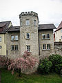
Zwingerturm in the house Zwinger 15 built in
more pictures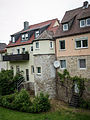
Zwingerturm in the house Zwinger 5 built in
more pictures
Mauerturm Zwinger 1
more pictures
Mauerturm Zwinger 1
more pictures
Zwingerturm at Pfarrgasse 5
more pictures
Zwingerturm south of Kellereistraße 13
more pictures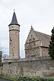
Nikolausturm
more pictures


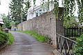
Fortification of Goßmannsdorf am Main
The late medieval fortifications have been preserved in their entire course and come from the 16th and 17th centuries. Century. The ring wall made of quarry stone masonry has three round towers and numerous semicircular shell towers. The gates have come off. The ditch area is used all around as a garden area. In the north there used to be a kennel. In the west there is a gate-like opening of the reinforced ring wall to block the stream bed. Pictures . File number: D-6-79-170-269. In a clockwise direction starting at the former Swedish Gate, the following objects have been preserved.
| location | object | description | File no. | image |
|---|---|---|---|---|
| Am Schwedentor 2 ( location ) |
Local wall | late medieval | D-6-79-170-269 |

|
| Linke Bachgasse 1 ( location ) |
Tower stump | and remains of the town wall, late medieval | D-6-79-170-269 |

|
| Zehnthofstraße 2 ( location ) |
Local wall | late medieval | D-6-79-170-269 |

|
| Zehnthofstraße 4 ( location ) |
Local wall | with tower stump, late medieval | D-6-79-170-269 |

|
| Zehnthofstraße 6 ( location ) |
Local wall | late medieval | D-6-79-170-269 |

|
| Zehnthofstraße 8 ( location ) |
Local wall | late medieval | D-6-79-170-269 |

|
| Linke Bachgasse 6 ( location ) |
Local wall | late medieval | D-6-79-170-269 | |
| Linke Bachgasse 7 ( location ) |
Local wall | late medieval | D-6-79-170-282 |

|
| Linke Bachgasse 8 ( location ) |
Local wall | with attachment stump, late medieval | D-6-79-170-283 |

|
| Linke Bachgasse 11 ( location ) |
Local wall | late medieval | D-6-79-170-269 |
|
| Domherrnviertel 8 ( location ) |
Local wall | late medieval | D-6-79-170-269 |

|
| Domherrnviertel 10 ( location ) |
Local wall | late medieval | D-6-79-170-269 |
|
| Domherrnviertel 20 ( location ) |
Round tower | late medieval | D-6-79-170-269 |
|
| Domherrnviertel 20 ( location ) |
Local wall | late medieval | D-6-79-170-269 |

|

Domherrnviertel, Zeilweg 8

Domherrnviertel, Zeilweg 6
Domherrnviertel, Linke Bachgasse 19


| location | object | description | File no. | image |
|---|---|---|---|---|
| Zielsgasse 1 ( location ) |
Local wall | late medieval | D-6-79-170-269 |

|
| Zehnthofstraße 37 ( location ) |
Local wall | late medieval | D-6-79-170-269 | |
| Zehnthofstraße 39 ( location ) |
Round tower | late medieval | D-6-79-170-269 |

|
| Zehnthofstraße 39 ( location ) |
Local wall | late medieval | D-6-79-170-269 |

|
| Zehnthofstraße 35 ( location ) |
Local wall | late medieval | D-6-79-170-269 |

|
| Zehnthofstraße 33 ( location ) |
Local wall | late medieval | D-6-79-170-269 |
|
| Zehnthofstraße 29 ( location ) |
Local wall | late medieval | D-6-79-170-269 | |
| Zehnthofstraße 27 ( location ) |
Local wall | late medieval | D-6-79-170-269 | |
| Zehnthofstraße 25 ( location ) |
Local wall | late medieval | D-6-79-170-269 | |
| Lehmgrubenweg 8 ( location ) |
Local wall | late medieval | D-6-79-170-269 |

|
| Zehnthofstraße 21 ( location ) |
Local wall | late medieval | D-6-79-170-269 |

|
| Zehnthofstraße 19 ( location ) |
Local wall | late medieval | D-6-79-170-269 |
|
| Lehmgrubenweg 6 ( location ) |
Round tower | late medieval | D-6-79-170-269 |

|
| Lehmgrubenweg 6 ( location ) |
Local wall | late medieval | D-6-79-170-269 |

|
| Zehnthofstraße 15 ( location ) |
Local wall | late medieval | D-6-79-170-269 |

|
| Zehnthofstraße 13 ( location ) |
Local wall | late medieval | D-6-79-170-269 |

|
| Zehnthofstraße 11 ( location ) |
Local wall | late medieval | D-6-79-170-269 |

|
| Lehmgrubenweg 2 ( location ) |
Round tower | late medieval | D-6-79-170-269 |

|
| Lehmgrubenweg 2 ( location ) |
Local wall | late medieval | D-6-79-170-269 |

|
| Right Bachgasse 1 ( location ) |
Local wall | late medieval | D-6-79-170-269 |
Individual monuments according to districts
Ochsenfurt
There are over 200 individual monuments in the Ochsenfurt Old Town ensemble . In addition, 17 images of places and streets of particular importance are identified, called special areas for short . First, the individual monuments of the special areas are listed, then the rest of the old town ensemble outside the special areas.
Badgasse
Badgasse is a narrow, paved alley on sloping terrain. It is built on closed with smaller, mostly two-story, gable and eaves town houses, predominantly from the 16th to 18th centuries. Century. Today's numbers 9 and 11 form the area of the Kastenhof formerly owned by the Würzburg Knights' Monastery of St. Burkard, which largely burned down around 1900. Boundary: Badgasse 1–14, 16, Hauptstrasse 40, Kolpingstrasse 2, Untere Reedersgasse 7, 22 .
Badgasse

| location | object | description | File no. | image |
|---|---|---|---|---|
| Badgasse 4 ( location ) |
Residential buildings | two-storey, plastered gable roof with half-timbered upper storey protruding on consoles, 16. – 18. century | D-6-79-170-4 |

|
| Badgasse 5 ( location ) |
Residential building with the Fröhlich wine bar, which existed from 1896 to 2010 | two-storey, plastered hipped roof building with half-timbered upper storey, bricked up baroque arcades, front part of the building 1471 (dendro. dat.), rear part of the building, 1463 (dendro. dat.) | D-6-79-170-5 |
![Residential building with the Fröhlich wine bar, which existed from 1896 to 2010 [3]](https://de.wikipedia.org/wiki/Datei:Ochsenfurt,_Badgasse_5-001.jpg) more pictures |
| Badgasse 5 ( location ) |
House figure | Madonna | D-6-79-170-5 |
 more pictures |
| Badgasse 8, 10 ( location ) |
Duplex house | two-storey, plastered half-hipped or gable roof building with a timber-framed upper storey protruding on the eaves, 16th-18th century | D-6-79-170-7 |
 more pictures |
| Badgasse 9 ( location ) |
Zehnthof, so-called Bukard'scher Kastenhof | two-storey, plastered gable roof building with stepped gables, marked 1601 | D-6-79-170-8 |
 more pictures |
| Badgasse 9 ( location ) |
Heraldic relief | marked 1702 | D-6-79-170-8 |
 more pictures |
| Badgasse 11 ( location ) |
Residential buildings | two-storey, plastered solid building with hipped roof and gate passage, marked 1792 | D-6-79-170-10 |
 more pictures |
| Badgasse 13 ( location ) |
Residential buildings | two-storey solid construction with half-hipped roof, 18th / 19th centuries Century over older core | D-6-79-170-11 |
 more pictures |
Pit lane
Boxgasse is a long, paved alley that leads downhill on the inside of the eastern part of the city wall to the Centturm. The side opposite the wall is closed with simple, mostly two-story, gable and eaves residential houses from the 18th and 19th centuries, which often contain an older core. Boundary : Boxgasse 1-39
| location | object | description | File no. | image |
|---|---|---|---|---|
| Boxgasse 1 ( location ) |
Residential buildings | Two-storey, plastered solid building in a corner position, with a pitched roof and drilled window frames, marked 1763, the core around 1550 | D-6-79-170-13 |
 more pictures |
| Boxgasse 1 ( location ) |
House Madonna | probably 16th century | D-6-79-170-13 |
 more pictures |
| Boxgasse 3 ( location ) |
House Madonna | Sandstone, 19th century | D-6-79-170-14 |
|
| Boxgasse 10 ( location ) |
Former residential building | two-storey, plastered gable roof building with half-timbered upper storey, 18th / 19th centuries century | D-6-79-170-16 |
|
| Boxgasse 18 ( location ) |
Former residential building | two-storey, plastered gable roof building with protruding half-timbered upper storey and dormer, in the core 17th / 18th. century | D-6-79-170-19 |
|
Brueckenstrasse
After the main street, Brückenstraße is the widest and busiest street in the city center. At its intersection with the main street is the old town hall (No. 1), the main gate with the high bridge tower at its end was closed at the beginning of the 19th century. The street has a closed, gable and eaves, two-storey development, essentially from the 16th to 18th centuries. A small square is being created at Untere Redersgasse. The Brückenstraße joins the Alte Mainbrücke with a slight ascent. Boundary: Brückenstraße 1-24, 26, Spitalgasse 1, forecourt 2, 4 .
| location | object | description | File no. | image |
|---|---|---|---|---|
| Brückenstrasse 1 ( location ) |
Former town hall, so-called old town hall | elongated, three-storey solid building with a gable roof and southern pillory, 2nd half of the 15th century, with a north-western, tower-like extension with a Renaissance gable and round-arched shop window fittings, 16th / 17th century. century | D-6-79-170-26 |
 more pictures |
| Brückenstraße 4, 6, 8 ( location ) |
Triple house | symmetrically designed, four-storey saddle roof building with half-timbered upper floors, central building with house Madonna from the 18th century, marked 1606 | D-6-79-170-27 |
 more pictures |
| Brückenstrasse 6 ( location ) |
House Madonna | 18th century, marked 1606 | D-6-79-170-27 |
 more pictures |
| Brückenstrasse 10 ( location ) |
Gasthaus Anker | three-storey hipped roof building with half-timbered upper storeys, marked 1693 | D-6-79-170-28 |
 more pictures |
| Brückenstrasse 12 ( location ) |
Residential buildings | three-storey hipped roof building with half-timbered upper storeys, overbuilt courtyard passage and bay window, 17th century over an older core | D-6-79-170-29 |
 more pictures |
| Brückenstrasse 14 ( location ) |
Residential buildings | two-storey, plastered solid building with a gable roof, overbuilt gate entrance and drilled window frames, 17th / 18th centuries Century, over an older core, with two-storey, rear wing buildings with gable roofs, the northern one with a cantilevered half-timbered upper floor, 18th century | D-6-79-170-30 |
 more pictures |
| Brückenstrasse 16 ( location ) |
Former Saalhof | then Gasthaus zum Storchen, three-storey, plastered solid building with a gable roof, probably 16th century, remodeling in the 18th century; Rear building, two-storey, plastered saddle roof structure, in the core probably 18th century | D-6-79-170-31 |
 more pictures |
| Brückenstrasse 16 ( location ) |
Rear building | Two-storey saddle roof building with plastered half-timbered upper storey, in the core probably 18th century | D-6-79-170-31 |
 more pictures |
| Brückenstrasse 17 ( location ) |
Residential building | three-storey solid building with hipped roof and house integration, around 1880 | D-6-79-170-32 |
 more pictures |
| Brückenstrasse 18 ( location ) |
Residential buildings | two-storey, plastered mansard gable roof, partly with half-timbered upper storey, 18th / 19th century century | D-6-79-170-33 |
 more pictures |
| Brückenstrasse 21 ( location ) |
Residential buildings | two-storey, plastered half-hipped roof building with half-timbered upper storey, 18th / 19th centuries century | D-6-79-170-1 |
 more pictures |
| Brückenstrasse 23 ( location ) |
Residential buildings | two-storey, plastered half-hipped roof building with protruding half-timbered upper storey and house Madonna (stored), 16. – 18. century | D-6-79-170-34 |
 more pictures |
| Brückenstraße 24, forecourt 2 ( location ) |
Duplex house | three-storey, plastered gable roof building with half-timbered upper storeys, 16./17. century | D-6-79-170-35 |
 more pictures |
| Brückenstrasse 26 ( location ) |
Castle | Former core building of what was probably a ringed castle from the 14th century, barracks in the early 19th century, now a local museum, two-storey solid building with a plinth, saddle roof and stepped gables, essentially the 14th century, essentially the 15th century | D-6-79-170-36 |
 more pictures |
| Am Main ( location ) |
Old Main Bridge | multi-arch stone bridge, east with pointed pier templates, built in 1512–20 over the piers of a stone-wood bridge from around 1200–1350 with the participation of the Würzburg cathedral builder Hans Bock and the stonemason Hans Sparr, repairs and additions 1685–88 by Hans Platz and 1709, 1784 collapse of the bridge tower and three arches, these added in 1867, after the central arch was blown up in 1945 this and two other arches were replaced by modern concrete bridge in 1957 for wider waterways; this removed in 2007. 2012 Opening of a new building in the middle section as a pedestrian and bicycle bridge. | D-6-79-170-3 |
 more pictures |
| Near Alte Mainbrücke ( location ) |
Old Main Bridge | northern wing walls, early 16th century and late 17th century, and portal pillars, marked 1688 | D-6-79-170-3 |
more pictures |
| Am Main ( location ) |
Two stone figures of St. Johannes Nepomuk | 1958 | D-6-79-170-3 |
more pictures |
Grillengasse
The Grillengasse leads from the main street to the Zwinger. It is predominantly built on two floors, mostly with eaves-standing craftsmen's houses, some of which date back to the 16th century. No. 1–11 is a series of simple, massive eaves-standing houses from the 19th century in rubble masonry. Boundary : Grillengasse 1-17 .

The Grillengasse in north-south view

| location | object | description | File no. | image |
|---|---|---|---|---|
| Grillengasse 2 ( location ) |
Residential building | Two-storey saddle roof building with a protruding half-timbered upper storey, marked 1582 | D-6-79-170-44 |
|
| Grillengasse 4 ( location ) |
Residential buildings | Two-storey, plastered saddle roof building with half-timbered upper storey, the core around 1600 | D-6-79-170-45 |
 more pictures |
| Grillengasse 6 ( location ) |
Residential buildings | Two-storey, plastered gable roof building with half-timbered upper storey protruding on consoles, the core of the 16th century | D-6-79-170-46 |
 more pictures |
| Grillengasse 8 ( location ) |
Residential buildings | Zwerchhaus, 16.-18. Century, in the core 1405 | D-6-79-170-47 |
|
| Grillengasse 12 ( location ) |
Residential buildings | two-storey, plastered gable roof building with half-timbered upper storey protruding on consoles, 16th / 17th century | D-6-79-170-48 |
 more pictures |
| Grillengasse 13 ( location ) |
Residential buildings | two-storey, plastered gable roof with half-timbered upper storey protruding on consoles, 16./17. century | D-6-79-170-49 |
 more pictures |
| Grillengasse 17 ( location ) |
Residential buildings | Two-storey, plastered gable roof with half-timbered upper storey projecting on consoles, 16th century | D-6-79-170-50 |
 more pictures |
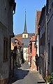
Main road
The main street leading from the Klingentor to the Upper Gate is the widest and longest street in the city and also market street. It is divided into four sections by three square-like extensions to the parish church of St. Andreas, in front of the New Town Hall and at the confluence with Wagstrasse. Boundary: Hauptstrasse 1-74, Brückenstrasse 1, 2, Kolpingstrasse 2, 4/6, Obere Manggasse 2, 3, Untere Klingenstrasse 1, Wagstrasse 2, Zwinger 20, 31.
| location | object | description | File no. | image |
|---|---|---|---|---|
| Hauptstrasse 1 ( location ) |
Blade Gate | see city fortifications | D-6-79-170-51 | |
| Hauptstrasse 2 ( location ) |
Former tithe building | Two-storey, plastered solid building with a gable roof and stepped gable, the core of the 15th century | D-6-79-170-52 |
 more pictures |
| Hauptstrasse 4 ( location ) |
Madonna figure | 18th century | D-6-79-170-53 |
|
| Hauptstrasse 5, 7 ( location ) |
Duplex house | two-storey, plastered mansard hipped roof building, partly timber-frame, 17th / 18th century century | D-6-79-170-54 |
 more pictures |
| Hauptstrasse 8 ( location ) |
Residential buildings | two-storey, plastered half-hipped roof building with corner blocks, the core probably from the late Middle Ages | D-6-79-170-55 |
 more pictures |
| Hauptstrasse 9 ( location ) |
Residential buildings | Two-storey, plastered half-hipped roof building in a corner position, with a half-timbered upper floor protruding on consoles and house Madonna from the 18th century, the core of the building probably 15th / 16th. century | D-6-79-170-56 |
 more pictures |
| Hauptstrasse 11 ( location ) |
Residential buildings | three-storey saddle roof building with slightly protruding half-timbered upper storeys, the core of the 15th century | D-6-79-170-57 |
 more pictures |
| Hauptstrasse 12 ( location ) |
Residential buildings | three-storey, plastered saddle roof building with half-timbered upper storey and baroque window frames, the core of the 16th century | D-6-79-170-58 |
 more pictures |
| Hauptstrasse 13 ( location ) |
Residential buildings | three-storey, plastered half-hipped roof building, 19th century | D-6-79-170-59 |
 more pictures |
| Hauptstrasse 14, 16 ( location ) |
Duplex house | three-storey saddle roof building in a corner position, with richly carved half-timbered upper storeys, massive, southern gable wall with stepped gable, extensive rear buildings from the 15th-17th centuries. Century, front building marked 1565, partially changed in the 18th century | D-6-79-170-60 |
 more pictures |
| Hauptstrasse 14 ( location ) |
House figure of the Holy Family | 18th century | D-6-79-170-60 |
 more pictures |
| Hauptstrasse 16 ( location ) |
House figure of a St. Bishop | 19th century | D-6-79-170-60 |
 more pictures |
| Hauptstrasse 15 ( location ) |
Residential buildings | Two-storey half-timbered building with a gable roof, the ground floor is heavily shaped, with a house Madonna from the 18th century, 16th century | D-6-79-170-61 |
 more pictures |
| Hauptstrasse 17 ( location ) |
Residential buildings | three-storey, plastered hipped roof building with rich baroque structure, early 18th century | D-6-79-170-63 |
 more pictures |
| Hauptstrasse 18 ( location ) |
Residential buildings | narrow, four-storey saddle roof building with projecting half-timbered upper storeys, 17th / 18th centuries century | D-6-79-170-64 |
 more pictures |
| Hauptstrasse 20 ( location ) |
Residential buildings | three-storey saddle roof building with protruding half-timbered upper storeys, 17th / 18th centuries century | D-6-79-170-65 |
 more pictures |
| Hauptstrasse 21 ( location ) |
Residential buildings | Three-storey, plastered gable roof building with slightly protruding half-timbered upper storeys, essentially 17th century, ground floor changed in the early 19th century | D-6-79-170-66 |
 more pictures |
| Main street ( location ) |
War memorial | for the fallen in the war of 1914/18, sculpture of St. George slaying the dragon, limestone, around 1920 | D-6-79-170-100 |
 more pictures |
| Hauptstrasse 22 ( location ) |
Residential buildings | Three-storey saddle roof building with half-timbered upper storeys protruding on consoles, marked 1729, over an older core | D-6-79-170-67 |
 more pictures |
| Hauptstrasse 23 ( location ) |
Residential buildings | two-storey saddle roof building with half-timbered upper storey, with a figure of a Maria Immaculata from the 18th century, building 16th / 17th century Century, with changes in the 18th century | D-6-79-170-68 |
 more pictures |
| Hauptstrasse 24 ( location ) |
Residential buildings | three-storey saddle roof building with half-timbered upper storeys protruding on consoles, 17th / 18th centuries century | D-6-79-170-69 |
 more pictures |
| Hauptstrasse 25 ( location ) |
Residential buildings | three-storey solid building with hipped roof and figure of St. Joseph, this is marked 1805, facade of the 19th century, with an older core | D-6-79-170-70 |
 more pictures |
| Hauptstrasse 26 ( location ) |
Residential buildings | three-storey saddle roof building with protruding half-timbered upper storeys and a roof towed to the east, marked 1607 | D-6-79-170-71 |
 more pictures |
| Hauptstrasse 29 ( location ) |
Residential buildings | three-storey, plastered solid building with hipped roof, house integration and house figure of a Maria Immaculata from the 18th century in a corner position, around 1850 | D-6-79-170-72 |
 more pictures |
| Hauptstrasse 31 ( location ) |
Pharmacy, so-called council pharmacy | Three-storey, elongated hipped roof building, with half-timbered upper storeys protruding on consoles, plastered, 15th / 16th centuries. century | D-6-79-170-73 |
 more pictures |
| Hauptstraße 32 ( ) |
basement, cellar | of the abandoned previous building, late Gothic
not re-qualified, not mapped in the Bavarian Monument Atlas |
D-6-79-170-394 |
 more pictures |
| Hauptstrasse 33 ( location ) |
Residential buildings | three-storey, plastered hipped roof building in corner position with drilled window frames, early 18th century | D-6-79-170-74 |
 more pictures |
| Hauptstrasse 34 ( location ) |
Residential buildings | Three-storey, partially plastered half-hipped roof building with half-timbered upper storeys projecting on consoles, in the core 15th / 16th. Century, changed in the 18th century | D-6-79-170-75 |
 more pictures |
| Hauptstrasse 35 ( location ) |
Residential buildings | three-storey, plastered gable roof with half-timbered upper storeys protruding on consoles, 16th century | D-6-79-170-76 |
 more pictures |
| Hauptstrasse 37 ( location ) |
Gasthof Kautzen | three-storey hipped mansard roof with half-timbered upper storeys canting on consoles, in the core 15th / 16th. century | D-6-79-170-77 |
 more pictures |
| Hauptstrasse 38 ( location ) |
Residential buildings | narrow, three-storey saddle roof building with half-timbered upper storeys protruding on consoles, plastered, in the core 16th century | D-6-79-170-78 |
 more pictures |
| Sterngasse 2, 4, Hauptstraße 39a ( location ) |
Former rent office building | three-storey, massive gable roof building, marked 1525, partially renewed | D-6-79-170-79 |
|
| Hauptstrasse 39 ( location ) |
So-called Bürgerhof | three-storey solid building with gable roof, gate passage and drilled window frames, end of the 18th century, over an older core | D-6-79-170-79 |
 more pictures |
| Hauptstrasse 40 ( location ) |
Pharmacy, so-called city pharmacy | Three-storey saddle roof building with half-timbered upper storeys cantilevered on consoles with mask carvings, house Madonna of the 18th century, and two-storey annex at the rear, the core of the building is late medieval, remodeled in the 18th century | D-6-79-170-80 |
 more pictures |
| Hauptstrasse 41 ( location ) |
Residential buildings | three-storey, plastered solid building with a hipped roof in a corner, with house structure and house figure of St. Johann Nepomuk, 18th century | D-6-79-170-81 |
|
| Hauptstrasse 41 ( location ) |
Rear building | two-storey, plastered half-hipped roof construction, at the same time | D-6-79-170-81 |
|
| Hauptstrasse 42 ( location ) |
Former farm building | Today residential building, two-storey solid building with half-hipped roof, in the core of the 16th century | D-6-79-170-111 |
|
| Hauptstrasse 42 ( location ) |
So-called New Town Hall | Town hall, three-sided free-standing saddle roof building with plastered timber frame protruding to the west on consoles, solid narrow sides, with stepped gables, clock turrets with pointed helmets, house Madonna from and outside staircase with late Gothic tracery parapet, before 1497 to around 1513, with eastern, two-storey extension with gable roof and staircase gable 1514 1515, with equipment | D-6-79-170-82 |
 more pictures |
| Hauptstrasse 42 ( location ) |
Wall fountain | with oval fountain bowl in relief and fountain mask, 1488–99 | D-6-79-170-82 |
|
| Main street ( location ) |
crucifix | on a broad pedestal with a figure of Our Lady in mourning, sandstone, 18th century | D-6-79-170-83 |
 more pictures |
| Hauptstrasse 43 ( location ) |
Residential buildings | Two-storey, plastered half-hip roof building with drilled window frames, 18th century, over an older core | D-6-79-170-84 |
 more pictures |
| Hauptstrasse 45 ( location ) |
Residential buildings | two-storey, plastered hipped roof building with protruding half-timbered upper storeys and eastern courtyard passage, ground floor heavily shaped, 16th-18th centuries century | D-6-79-170-85 |
 more pictures |
| Hauptstrasse 46 ( location ) |
Residential buildings | three-storey, plastered gable roof building with protruding half-timbered upper storeys, ground floor heavily overformed, in the core 16th century | D-6-79-170-86 |
|
| Hauptstrasse 47 ( location ) |
Gasthof Post | three-storey, plastered solid building with hipped roof, drilled window frames, gate passage and southern wing extension, marked 1761 | D-6-79-170-87 |
 more pictures |
| Hauptstrasse 48 ( location ) |
Residential buildings | three-storey solid building with gable roof and facade, ground floor heavily overformed, 19th century | D-6-79-170-88 |
 more pictures |
| Hauptstrasse 50 ( location ) |
Residential buildings | three-storey, plastered gable roof building with protruding half-timbered upper storeys, ground floor heavily overformed, in the core 16th century | D-6-79-170-90 |
 more pictures |
| Hauptstrasse 51 ( location ) |
Former hospital courtyard | two-storey solid building with hipped roof, rich baroque facade and gate passage, marked 1720 | D-6-79-170-91 |
 more pictures |
| Hauptstrasse 52 ( location ) |
Residential buildings | three-storey, plastered saddle roof building with half-timbered upper storeys protruding on consoles, the core of the 16th century | D-6-79-170-92 |
 more pictures |
| Hauptstrasse 60 ( location ) |
Residential buildings | Three-sided free-standing, three-storey hipped roof building with half-timbered upper storeys projecting on consoles, plastered, ground floor heavily overformed, core 15th / 16th. century | D-6-79-170-94 |
 more pictures |
| Hauptstrasse 62 ( location ) |
Residential buildings | three-storey, plastered gable roof building with half-timbered upper storeys, ground floor heavily overformed, 17th century | D-6-79-170-95 |
 more pictures |
| Hauptstrasse 68 ( location ) |
Residential buildings | three-story, plastered gable roof building, 19th century | D-6-79-170-96 |
 more pictures |
| Hauptstrasse 70 ( location ) |
Residential buildings | narrow, three-storey building with hipped roof, plastered, 19th century | D-6-79-170-97 |
 more pictures |
| Hauptstrasse 72 ( location ) |
Residential buildings | three-storey, plastered gable roof building in corner position, 19th century | D-6-79-170-98 |
 more pictures |
| Hauptstrasse 74 ( location ) |
Former seat of the nobility, the so-called Count's Königseggisches Haus, now Hotel Bären | In the western core a three-storey solid building with hipped roof, risalit bay window and house integration, 18th century, later extended to include an eastern extension in the form of a copy of the core building | D-6-79-170-99 |
 more pictures |
| Obere Boxgasse 1 ( location ) |
Former farm building | Four-story, plastered solid building with a gable roof, inscription panel marked 1891 | D-6-79-170-99 associated |
 more pictures |
| Jahnstraße 2 ( location ) |
Former farm building | Two-storey quarry stone masonry building with a gable roof and pilaster structure, 2nd half of the 19th century | D-6-79-170-99 associated |
|
| Obere Manggasse 2 ( location ) |
Residential buildings | two-storey, plastered half-hipped roof building in corner position, with half-timbered upper storey, 16. – 18. century | D-6-79-170-147 |
 more pictures |
| Obere Manggasse 3 ( location ) |
Gasthaus Ross | two-storey, plastered mansard half-hipped roof building in corner position, with timber-framed upper storey protruding on consoles, in the core 16th-18th Century, 19th century facade | D-6-79-170-148 |
 more pictures |
| Wagstrasse 2 ( location ) |
Residential buildings | two-storey, plastered half-hipped roof building in corner position, with cantilevered half-timbered upper storey, in the core 15th / 16th. Century, changes 18./19. century | D-6-79-170-221 |
 more pictures |
| Wagstrasse 6 ( location ) |
Residential buildings | Two-storey, plastered gable roof building in corner position, with house integration, 2nd half of the 19th century | D-6-79-170-223 |
|
| Zwinger 20 ( location ) |
Residential buildings | three-storey, plastered gable roof building with hip foot and half-timbered upper storeys cantilevered on consoles, 16. – 18. century | D-6-79-170-231 |
 more pictures |
Kellereistraße
The cellar street starts from the main street, leads past the former palatium and breaks through the city wall at its southern end. It has a closed, two-storey gable and eaves structure, mostly with residential buildings from the 16th to 18th centuries. Boundary: Kellereistraße 1–13 .

Kelleistrasse view from the south

| location | object | description | File no. | image |
|---|---|---|---|---|
| Kellereistraße 4 ( location ) |
Residential buildings | two-storey, plastered hipped roof building in a corner position, with a protruding half-timbered upper storey and house figure, 18th century | D-6-79-170-101 |
 more pictures |
| Kellereistraße 5 ( location ) |
Former residential building | two-storey, plastered gable roof with half-timbered upper storey protruding on consoles, 16./17. century | D-6-79-170-102 |
 more pictures |
| Kellereistraße 6 ( location ) |
Residential buildings | two-storey, plastered hipped roof building with half-timbered upper storey and drilled window frames, 18th century | D-6-79-170-103 |
 more pictures |
| Kellereistraße 7 ( location ) |
Residential buildings | Two-storey, partially plastered gable roof building with timber-framed upper floor protruding to the east, solid rear part of the building with stepped gable, 15th century core, timber-framed 16th / 17th century. century | D-6-79-170-104 |
 more pictures |
| Kellereistraße 7 ( location ) |
Rear building | two-storey, plastered gable roof building, with drilled window frames, 17th / 18th centuries century | D-6-79-170-104 |
|
| Kellereistraße 8 ( location ) |
Former district court | two-storey, plastered solid building with hipped roof, baroque structure and richly designed portal, with an L-shaped saddle roof building to the east, early 18th century, in the core 1495 | D-6-79-170-105 |
 more pictures |
| Kellereistraße 11 ( location ) |
Former cathedral chapter palatium, residential and warehouse building, so-called Templar Church, then district office building, now district office | Three-storey quarry stone masonry building with a gable roof, stepped gables decorated with figures, stair tower and cross-vaulted ground floor hall, 1491-1499, changes on 19th and 20th centuries. Century | D-6-79-170-106 |
 more pictures |
| Kellereistraße 13 ( location ) |
Former domkapitel cellar, so-called blue cellar, then district office building, now district office | Two-storey solid building with a gable roof, round tower, house structure and pointed-arched entrance gate, essentially 16th century, over the older core probably from the 14th century, remodeling by Georg Bayer, 1714 | D-6-79-170-106 |
 more pictures |
| Kellereistraße 11, 13 ( location ) |
Draw well | Crossbeam of the well gallows with a coat of arms relief, modern additions, sandstone, inscribed 1549 | D-6-79-170-106 |
 more pictures |
church Square
On the south side of the parish church is the church square with the former cemetery chapel, which was surrounded by the cemetery established in 1542 until the 19th century. Boundary: Kirchplatz 1-5, 7, Pfaffengasse 8, 10, 12 .
| location | object | description | File no. | image |
|---|---|---|---|---|
| Kirchplatz 1, Kirchplatz 3, Kirchplatz ( location ) |
Catholic parish church St. Andreas | three-aisled late-Gothic hall church with a single-nave choir, 2nd half of the 14th century, six-storey tower with a pointed helmet on the north side of the choir, 13th century core, 17th / 18th century additions. Century; with equipment | D-6-79-170-107 |
 more pictures |
| Kirchplatz 1, Kirchplatz 3, Kirchplatz ( location ) |
Mount of Olives Chapel | Vaulted extension with parapet, probably 1510–20, with life-size sandstone figures from the late 16th century | D-6-79-170-107 |
 more pictures |
| Kirchplatz 1, Kirchplatz 3, Kirchplatz ( location ) |
Mission cross | Crucifix on an older pedestal with an inscription cartouche from the 18th century, sandstone, inscribed 1923 | D-6-79-170-107 |
 more pictures |
| Kirchplatz 2 ( location ) |
Former school building | Two-storey, plastered saddle roof building with a basement, house structure and eastern stand bay window, neo-renaissance, around 1870 | D-6-79-170-108 |
 more pictures |
| Kirchplatz 4 ( location ) |
Former cemetery chapel | now cath. St. Michael Chapel, two-storey, late Gothic hall building with a choir and outside staircase, marked 1444, vault marked 1492, with furnishings | D-6-79-170-109 |
 more pictures |
Kolpingstrasse
The Kolpingstrasse is a partially paved, closed built street with two-storey residential buildings from the 15th / 16th centuries. to the 19th century, which are mainly arranged at the gable in the front section of the street up to the confluence with Manggasse. At numbers 4/6, 8, 10, the street is expanded like a square around a draw well. The space is dominated by the two north gable fronts of the New Town Hall. Boundary : Kolpingstrasse 1-24, Boxgasse 1, Obere Boxgasse 10, 12 .
| location | object | description | File no. | image |
|---|---|---|---|---|
| Kolpingstrasse 2 ( location ) |
Residential buildings | three-storey, plastered hipped roof building in a corner position with half-timbered upper storeys, baroque plaster structure, building from the early 18th century | D-6-79-170-112 |
 more pictures |
| Kolpingstrasse 2 ( location ) |
House figure | Archangel Michael, inscribed 1765 | D-6-79-170-112 |
 more pictures |
| Kolpingstrasse 5 ( location ) |
Residential buildings | two-storey, plastered mansard cripple hipped roof building with half-timbered upper storey, 18th / 19th century century | D-6-79-170-113 |
|
| Kolpingstrasse 8 ( location ) |
Residential buildings | two-storey, plastered saddle roof building with half-timbered upper storey and gate passage, 18th / 19th centuries century | D-6-79-170-114 |
 more pictures |
| Kolpingstrasse ( location ) |
Draw well | with a gallows made of two stone pillars decorated with coats of arms reliefs, a roofed wooden crossbeam and an oval fountain surround, marked 1573 | D-6-79-170-123 |
 more pictures |
| Kolpingstrasse 9 ( location ) |
Residential buildings | two-storey, plastered gable roof building with half-timbered upper storey protruding on consoles, buildings 16. – 18. century | D-6-79-170-115 |
 more pictures |
| Kolpingstrasse 9 ( location ) |
House Madonna | 18th century | D-6-79-170-115 |
 more pictures |
| Kolpingstrasse 10 ( location ) |
Residential buildings | three-storey, plastered gable roof building with half-timbered upper storeys, marked 1552 | D-6-79-170-116 |
 more pictures |
| Kolpingstrasse 12 ( location ) |
Residential buildings | three-storey, plastered half-hip roof building in a corner position with half-timbered upper storeys, over an older core | D-6-79-170-117 |
 more pictures |
| Kolpingstrasse 12 ( location ) |
House Madonna | 18th century | D-6-79-170-117 |
 more pictures |
| Kolpingstrasse 18 ( location ) |
Residential buildings | Two-storey, plastered solid building with a gable roof and drilled window frames, 18th century, 19th century dwelling | D-6-79-170-118 |
 more pictures |
| Kolpingstrasse 19 ( location ) |
Residential buildings | two-storey, plastered solid building with a mansard gable roof, baroque style, around 1900 | D-6-79-170-119 |
 more pictures |
| Kolpingstrasse 20 ( location ) |
Residential buildings | two-storey, plastered solid building with gable roof, in the core 16./17. century | D-6-79-170-120 |
 more pictures |
| Kolpingstrasse 22 ( location ) |
Residential buildings | two-storey, plastered saddle roof construction, in the core 16./17. century | D-6-79-170-121 |
|
| Kolpingstrasse 23 ( location ) |
House figure | St. Joseph, 19th century | D-6-79-170-141 |
|
| Kolpingstrasse 24 ( location ) |
Residential buildings | two-storey solid building with a mansard half-hipped roof in the corner, quarry stone with house stone integration, early 19th century | D-6-79-170-122 |
 more pictures |
Langgasse
The Langgasse leads from the main street to the Zwinger and is two-story, built on the eaves and gable. The front, wider part is visually completed by the gable facade of No. 4. Boundary: Langgasse 1-13 .
| location | object | description | File no. | image |
|---|---|---|---|---|
| Langgasse 4 ( location ) |
Former residential building | two-storey, plastered saddle roof building with half-timbered upper storey, freestanding on three sides, in the core 15th / 16th. century | D-6-79-170-124 |
 more pictures |
| Langgasse 5 ( location ) |
Residential buildings | two-storey, plastered gable roof building with gate passage, upper storey partly timber-framed, 17th / 18th century. century | D-6-79-170-125 |
 more pictures |
| Langgasse 7 ( location ) |
Residential buildings | two-storey, plastered gable roof with half-timbered upper storey protruding on consoles, 17th / 18th century | D-6-79-170-126 |
 more pictures |
| Langgasse 9 ( location ) |
Residential buildings | two-storey, plastered gable roof building with the upper storey protruding on consoles, 17th / 18th centuries Century | D-6-79-170-128 |
 more pictures |
| Langgasse 9 ( location ) |
Residential buildings | two-storey, plastered saddle roof building with timber-framed upper storey projecting on consoles, in the core 15th / 16th. century | D-6-79-170-127 |
more pictures |
Mangstrasse
Mangstrasse is a slightly curved, closed, two-story lane on gently sloping terrain. It consists of gabled and eaves breeches, the core of which mostly dates back to the 16th century and some renovations from the 18th to 20th centuries. Century show. Boundary : Mangsstrasse 1-23, 25 .
| location | object | description | File no. | image |
|---|---|---|---|---|
| Mangstrasse 2 ( location ) |
House figure | Maria Immaculata on console, 19th century | D-6-79-170-129 |
|
| Mangstrasse 6 ( location ) |
Residential buildings | three-storey, plastered saddle roof building with half-timbered upper floors above a high basement, as well as a covered courtyard passage with plastered half-timbered upper floor and saddle roof, 17th century, with changes from the 18th century | D-6-79-170-130 |
 more pictures |
| Mangstrasse 8 ( location ) |
Residential buildings | three-storey, plastered gable roof building with half-timbered upper storeys, 16./17. Century, remodeling marked 1695 | D-6-79-170-131 |
|
| Mangstrasse 9 ( location ) |
House figure | St. Joseph, 19th century | D-6-79-170-132 |
|
| Mangstrasse 17 ( location ) |
Residential buildings | two-storey, plastered mansard half-hipped roof building in corner position, 18th / 19th century century | D-6-79-170-133 |
 more pictures |
Upper pit lane
The Obere Boxgasse is a narrow, slightly curved alley. On its western side, it is lined with two- or three-storey residential buildings, the core of which is often in the 15th / 16th Go back to the century. The former city wall, which ran eastwards, was built in the 19th and 20th centuries. Century replaced by industrial buildings of a brewery. Boundary : Obere Boxgasse 2, 4, 6, 8, 10, 12, Wagstraße 6 .
| location | object | description | File no. | image |
|---|---|---|---|---|
| Obere Boxgasse 4 ( location ) |
Residential buildings | Two-storey, plastered gable roof building with half-timbered upper storey protruding on consoles, essentially 16th century, changed in the 18th century | D-6-79-170-139 |
|
| Obere Boxgasse 10 ( location ) |
Gabled house | two-storey, plastered saddle roof building with cantilevered half-timbered upper storey, in the core 15th / 16th. century | D-6-79-170-140 |
|
Obere Klingengasse
Obere Klingengasse is a dead end from the main street at the Klingentor. It is dominated by the front gabled houses 11 and 13, which are towered over by the stepped gable of the district office building (cellar street 13) and form a picturesque group with this. The rest of the buildings are mostly eaves and partially show stone masonry facades from the 19th century. Boundary: Obere Klingengasse 1-11, Kellereigasse 7 .
| location | object | description | File no. | image |
|---|---|---|---|---|
| Obere Klingengasse 13 ( location ) |
Residential buildings | two-storey, plastered gable roof building, re. 1642 | D-6-79-170-146 |
 more pictures |
Obere Redersgasse
Obere Redersgasse is a narrow, paved side street that rises towards the main street. It is closed, partially offset with two-storey residential buildings with eaves and gables, most of which have a late medieval core. Boundary : Obere Redersgasse 1-8, Hauptstrasse 30, 32, Mittlere Redersgasse 11, 18, Untere Redersgasse 3/5 .
| location | object | description | File no. | image |
|---|---|---|---|---|
| Obere Redersgasse 1 ( location ) |
Residential buildings | two-storey, plastered solid construction with a gable roof, tail gable and house Madonna, historicizing, around 1900 | D-6-79-170-152 |
 more pictures |
| Obere Redersgasse 3 ( location ) |
Duplex house | two-storey, plastered solid building with a half-hipped mansard roof, 19th century | D-6-79-170-153 |
 more pictures |
| Obere Redersgasse 4 ( location ) |
Residential buildings | Two-storey, plastered gable roof building with half-timbered upper storey protruding on consoles, the core of the 16th century | D-6-79-170-154 |
|
| Obere Redersgasse 7 ( location ) |
Residential buildings | two-storey, recessed solid building with gable roof, 18th / 19th centuries century | D-6-79-170-155 |
more pictures |
| Obere Redersgasse 7 ( location ) |
Former farm building | small solid building with saddle roof, 2nd half of the 19th century | D-6-79-170-155 |
 more pictures |
| Obere Redersgasse 8 ( location ) |
Former residential building | two-storey, plastered gable roof building with half-timbered upper storey, 18th / 19th centuries century | D-6-79-170-156 |
 more pictures |
| Untere Redersgasse 3, 5 ( location ) |
Double barn | Two-storey, partially plastered quarry stone masonry building with a gable roof and two large gate entrances, 19th century | D-6-79-170-209 |
 more pictures |
Pfarrgasse
The Pfarrgasse runs in an arch from the Kellereistraße to the Zwinger. In the front part it is irregularly two-storey, built on gable and eaves and loosened up with gardens. In the rear part it is closed with residential houses on the eaves. The largely arable bourgeois properties, mostly with plastered half-timbered upper floors, go back in essence to the 16th century. Boundary: Pfarrgasse 1–22 .
| location | object | description | File no. | image |
|---|---|---|---|---|
| Pfarrgasse 1 ( location ) |
Residential buildings | three-storey, plastered hipped roof building, freestanding on three sides, with half-timbered upper storeys protruding on consoles, 16th-18th centuries century | D-6-79-170-157 |
 more pictures |
| Pfarrgasse 5 ( location ) |
Residential buildings | three-storey plastered solid building with hipped roof, drilled window frames and large vaulted cellar, 17th century | D-6-79-170-158 |
 more pictures |
| Pfarrgasse 8 ( location ) |
Residential buildings | two-storey, plastered gable roof building in corner position, with slightly cantilevered half-timbered upper storey, 16th – 18th centuries century | D-6-79-170-159 |
 more pictures |
| Pfarrgasse 9 ( location ) |
Former rectory | three-storey, plastered solid building with hipped roof and rich house integration, in the core 1563, reconstruction according to plans by Joseph Greissing by Martin Stumer, 1711–13 | D-6-79-170-160 |
 more pictures |
| Pfarrgasse 12 ( location ) |
Residential buildings | two-storey, plastered gable roof with half-timbered upper storey protruding on consoles, 16. – 18. century | D-6-79-170-162 |
 more pictures |
| Pfarrgasse 12 ( location ) |
Courtyard gate | at the same time | D-6-79-170-162 |
 more pictures |
| Pfarrgasse 13 ( location ) |
Residential buildings | Two-storey quarry stone masonry building with a half-hipped mansard roof and house integration, early 19th century | D-6-79-170-163 |
 more pictures |
Rosshof
The Roßhof is a cul-de-sac from the main street. It is built with mostly two-story houses offset from the gable and eaves. It is given a picturesque accent by the free-standing house no. 3, and it is visually completed by house no. 9. Boundary: Roßhof 1-9 .
| location | object | description | File no. | image |
|---|---|---|---|---|
| Roßhof 1 ( location ) |
Residential buildings | three-storey, partially plastered gable roof with half-timbered upper storeys protruding on consoles, 16./17. century | D-6-79-170-164 |
 more pictures |
| Roßhof 2 ( location ) |
Eaves side building | two-storey, 1407 (d), modified in the 18th century | D-6-79-170-165 |
|
| Roßhof 2 ( location ) |
Economic section | three-story, 18th century | D-6-79-170-165 |
|
| Roßhof 2 ( location ) |
House Madonna | 18th century | D-6-79-170-165 |
|
| Roßhof 3 ( location ) |
Residential buildings | three-storey, plastered gable roof building, free-standing, with protruding half-timbered upper storeys, in the core 15th / 16th. century | D-6-79-170-166 |
 more pictures |
| Roßhof 6 ( location ) |
Former residential building | two-storey, plastered gable roof building with protruding half-timbered upper storey, 16./17. century | D-6-79-170-167 |
 more pictures |
| Roßhof 7 ( location ) |
Residential tower | massive, four-storey saddle roof building, 1226 (dendro. dat.), additional storey 1659 (dendro. dat.) | D-6-79-170-168 |
 more pictures |
| Roßhof 9 ( location ) |
Residential buildings | two-storey, plastered gable roof building with half-timbered upper storey, 18th century | D-6-79-170-169 |
 more pictures |
Spitalgasse

The Spitalgasse starts from Brückenstraße at the bridge gate and is slightly curved. It has a closed, partly staggered gable and eaves development, consisting of two-story houses, the core of which mostly dates back to the 16th century. Boundary: Spitalgasse 1-25 .
| location | object | description | File no. | image |
|---|---|---|---|---|
| Spitalgasse 1 ( location ) |
Gasthaus zur Krone | two-storey, plastered solid building with a gable roof, early 19th century | D-6-79-170-176 |
 more pictures |
| Spitalgasse 1 ( location ) |
Rear building | Two-storey, plastered gable roof building with a cantilevered half-timbered upper storey, marked 1589 in the core | D-6-79-170-176 |
more pictures |
| Spitalgasse 2, 4 ( location ) |
Duplex house | three-storey hipped roof building, eastern part of the building with saddle roof, with cantilevered half-timbered upper storeys, the core of the 16th century | D-6-79-170-177 |
 more pictures |
| Spitalgasse 9 ( location ) |
Residential buildings | Two-storey, plastered saddle roof building, heavily renovated, in the core of the 16th century | D-6-79-170-181 |
|
| Spitalgasse 10, 12 ( location ) |
Duplex house | Two-storey, plastered gable roof building, in the core 16th century, in the rear site city wall, 14th century | D-6-79-170-182 |
|
| Spitalgasse 13 ( location ) |
Former quarter master house of the red tanners | Residential building, so-called Greissinghaus, three-storey solid building with a pitched roof and rich baroque facade structure, in the style of Joseph Greissing, marked 1717 | D-6-79-170-183 |
 more pictures |
| Spitalgasse 14 ( location ) |
Residential buildings | Two-storey, plastered and clad saddle roof building with half-timbered upper storey, the core of the 16th century | D-6-79-170-184 |
|
| Spitalgasse 16; Spitalgasse 18; Near Spitalgasse ( location ) |
Former hospital | at the site of the former infirmary, Seelhaus from around 1400, founded around 1431 | D-6-79-170-185 |
.jpg) more pictures |
| Spitalgasse 16 ( location ) |
Former hospital church | now Catholic Herz-Jesu-Kirche, hall building with retracted choir and north-eastern choir flank tower with pointed helmet, choir around 1499, tower and vault 1616, west facade changed in the 18th century; with equipment | D-6-79-170-185 |
 more pictures |
| Spitalgasse 18 ( location ) |
Former hospital building | two-storey solid building with a gable roof and volute gable, marked 1609 | D-6-79-170-185 |
 more pictures |
| Spitalgasse 18 ( location ) |
Former hospital building | two-storey saddle roof building resting on arcades with half-timbered upper floor and southern half-timbered arcade, marked 1551 | D-6-79-170-185 |
 more pictures |
| Spitalgasse 18 ( location ) |
Former hospital courtyard | today war memorial site, with various grave monuments from the 19th and early 20th centuries, 15th – 17th centuries. century | D-6-79-170-185 |
more pictures |
| Spitalgasse 18 ( location ) |
Former hospital courtyard | Enclosure, with gate passage and gate, 15. – 17. century | D-6-79-170-185 |
 more pictures |
Lower Klingengasse
The Untere Klingengasse leads from the Klingentor to the forecourt. It is mostly built on the eaves side, two-storey, on the right, western side are mostly quarry stone houses from the 19th century. It opens onto the forecourt at the pigeon tower. Boundary: Untere Klingengasse 1-24 .
| location | object | description | File no. | image |
|---|---|---|---|---|
| Untere Klingengasse 2 ( location ) |
Former Vogteihof of the Carthusian Monastery of Tückelhausen | then Fronveste, today residential building, three-storey, plastered solid construction with gable roof and stepped gables, in the core 15th century | D-6-79-170-202 |
 more pictures |
| Untere Klingengasse 4, 6 ( location ) |
Duplex house | two-storey, plastered gable roof building with protruding half-timbered upper storey, 16. – 18. century | D-6-79-170-203 |
 more pictures |
| Untere Klingengasse 11, 13 ( location ) |
Residential buildings | Two-storey, plastered gable roof building, partly with a half-timbered upper storey, in the core probably 16th century, with house Madonna from the 18th century, the front building changed in the 18th century | D-6-79-170-205 |
 more pictures |
| Untere Klingengasse 11, 13 ( location ) |
Rear building | Two-storey, plastered saddle roof building with a cantilevered half-timbered upper storey, the core of the 16th century | D-6-79-170-205 |
|
Remaining old town
Outside of the “special areas” there are other individual monuments in the area of the Ochsenfurt Old Town ensemble.
| location | object | description | File no. | image |
|---|---|---|---|---|
| Floßhafenstrasse ( location ) |
Wayside shrine | Relief attachment with scene of the descent from the cross, on a winding column with tendril ornament over a renewed base, sandstone, inscribed 1702 | D-6-79-170-396 |
more pictures |
| Gleisweg, In Ochsenfurt, Oberer Stadtgraben ( location ) |
Wayside shrine | Relief attachment with a cross-crowned Coronation of Mary, on a pillar in relief over a table base, sandstone, inscribed 1696 | D-6-79-170-236 |
 more pictures |
| Gleisweg, In Ochsenfurt, Oberer Stadtgraben ( location ) |
Saint figure | Sculpture of Maria Immaculata on pedestal with inscription cartouche, above table base, sandstone, inscribed 1728 | D-6-79-170-237 |
 more pictures |
| Gleisweg, In Ochsenfurt, Oberer Stadtgraben ( location ) |
Wayside shrine | Figure of a cruiser on a bulged pillar above a base plate supported by a small pillar, sandstone, 18th century | D-6-79-170-238 |
 more pictures |
| Mittlere Badgasse 6 ( location ) |
Residential buildings | three-storey, plastered saddle roof building with a dwelling, the core of the 16th century | D-6-79-170-135 |
|
| Mittlere Redersgasse 1 ( location ) |
Former residential building | Two-storey, plastered solid building with a gable roof, stilted window profiles and half-timbered gable, 17th century | D-6-79-170-136 |
 more pictures |
| Mittlere Redersgasse 8 ( location ) |
Residential buildings | two-storey, plastered gable roof building, with facade from the 19th century, core older | D-6-79-170-137 |
 more pictures |
| Mittlere Redersgasse 14 ( location ) |
Residential buildings | two-storey, plastered gable roof building with half-timbered upper storey, 16. – 18. century | D-6-79-170-138 |
|
| Obere Manggasse 5 ( location ) |
Residential buildings | narrow, two-storey saddle roof building with a plastered half-timbered upper storey protruding on consoles, essentially the 16th century | D-6-79-170-149 |
 more pictures |
| Obere Manggasse 9 ( location ) |
Residential buildings | two-storey, plastered saddle roof building over a high basement and protruding half-timbered upper storey, 16th century | D-6-79-170-150 |
 more pictures |
| Obere Manggasse 11 ( location ) |
Residential buildings | Two-storey, plastered gable roof building in a corner position, with a base storey and a half-timbered upper storey, the core of the 16th century, archway marked 1841 | D-6-79-170-151 |
 more pictures |
| Roßmühlgasse 1 ( location ) |
Residential buildings | two-storey saddle roof building with half-timbered upper storey, in the core 1614 | D-6-79-170-170 |
 more pictures |
| Roßmühlgasse 1 ( location ) |
Courtyard gate | rounded, probably at the same time | D-6-79-170-170 |
|
| Saalhofgasse 3, 12 ( location ) |
Duplex house | two-storey, plastered half-hipped roof building in corner position, 18th / 19th century century | D-6-79-170-171 |
|
| Saalhofgasse 7 ( location ) |
Residential buildings | Two-storey, plastered half-hipped mansard roof with half-timbered upper storey projecting on consoles, in the core 15th century, overformed in the 18th century | D-6-79-170-172 |
|
| Saalhofgasse 9 ( location ) |
Dr. Sack House | Two-storey quarry stone masonry building with hipped roof and central projectile with triangular gable, after 1825 | D-6-79-170-218 |
 more pictures |
| Saalhofgasse 14 ( location ) |
Residential buildings | two-storey, plastered gable roof with half-timbered upper storey projecting on consoles, in the core 16./17. century | D-6-79-170-174 |
 more pictures |
| Saalhofgasse 16 ( location ) |
Residential buildings | two-storey, plastered saddle roof building with protruding half-timbered upper storey, in the core 15th / 16th. century | D-6-79-170-175 |
 more pictures |
| Sterngasse 3 ( location ) |
Residential buildings | two-storey, plastered solid building with half-hipped roof, historicizing, 2nd half of the 19th century | D-6-79-170-186 |
|
| Sterngasse 5, 7 ( location ) |
Residential buildings | two-storey, elongated solid building with half-hipped roof and corner bay window, historicizing, 2nd half of the 19th century | D-6-79-170-187 |
 more pictures |
| Untere Badgasse 2 ( location ) |
Residential buildings | two-storey, plastered gable roof construction, in the core 16th-18th centuries Century, 19th century facade, heavily overmolded | D-6-79-170-198 |
 more pictures |
| Untere Badgasse 6 ( location ) |
Residential buildings | two-storey, plastered gable roof building in corner position, in the core 16th century | D-6-79-170-199 |
 more pictures |
| Untere Badgasse 8 ( location ) |
Residential buildings | two-storey, plastered gable roof building with projecting half-timbered upper storey, with walled-in medallions from the 18th century, 16th-19th centuries. century | D-6-79-170-200 |
 more pictures |
| Untere Boxgasse 8 ( location ) |
Residential buildings | two-storey, plastered gable roof building in corner position, with cantilevered half-timbered upper storey, 18th / 19th century century | D-6-79-170-201 |
 more pictures |
| Untere Redersgasse 1 ( location ) |
Residential buildings | two-storey, plastered gable roof, partly with half-timbered upper storey, in the core 18th / 19th century century | D-6-79-170-207 |
 more pictures |
| Untere Redersgasse 2 ( location ) |
Former residential building | three-storey, plastered hipped roof building, 18th century | D-6-79-170-208 |
|
| Untere Redersgasse 4 ( location ) |
Residential buildings | two-storey, plastered saddle roof building, western part with cantilevered half-timbered upper storey, in the core 16th century, heavily overformed | D-6-79-170-210 |
 more pictures |
| Untere Redersgasse 7 ( location ) |
Residential buildings | two-storey, plastered solid building with a half-hipped mansard roof, 18th century | D-6-79-170-212 |
 more pictures |
| Untere Redersgasse 8 ( location ) |
Residential buildings | two-storey, narrow gable roof building, plastered, 17th century core, modernized | D-6-79-170-213 |
 more pictures |
| Untere Redersgasse 14 ( location ) |
Residential buildings | Back, two-storey saddle roof building with half-timbered upper floor, plastered, 17th / 18th century century | D-6-79-170-214 |
 more pictures |
| Untere Redersgasse 16 ( location ) |
Former residential building | Two-storey, partially plastered gable roof building with half-timbered upper storey, 17th century | D-6-79-170-215 |
 more pictures |
| Courtyard 4 ( location ) |
Residential buildings | three-storey, plastered gable roof building in corner position, partly with cantilevered half-timbered upper storey, 17th century core, heavily renovated | D-6-79-170-217 |
 more pictures |
| Wagstrasse 4 ( location ) |
Residential buildings | two-storey half-hipped roof building with half-timbered upper storey and large gate passage, marked 1834 | D-6-79-170-222 |
 more pictures |
| Zwinger 12 ( location ) |
Residential buildings | three-storey, plastered solid building with a gable roof, clapboard gable, 18th century core | D-6-79-170-227 |
 more pictures |
| Zwinger 18 ( location ) |
Residential buildings | two-storey, angled saddle roof building with half-timbered upper storey, plastered, in the core 16th century | D-6-79-170-229 |
|
Rest of the city center
| location | object | description | File no. | image |
|---|---|---|---|---|
| At the Landturm ( location ) |
Watch tower | So-called land or Mariaturm, high, six-storey round tower with an upper floor protruding over a round bulge, quarry stone masonry, probably early 15th century | D-6-79-170-235 | |
| At the Landturm ( location ) |
Saint figure | Archangel Michael with a falling from hell scene, sandstone, on a renewed base, 17th / 18th centuries century | D-6-79-170-239 | |
| At Wolfgang ( location ) |
Wayside shrine | Rocailla-framed relief attachment with Maria Immaculata, on pillar with foundation inscription, above base, sandstone, inscribed 1737 | D-6-79-170-196 | |
| At Wolfgang ( location ) |
crossroads | Crucifix on pedestal with foundation inscription, inscribed 1699 | D-6-79-170-195 | |
| Bahnhofsplatz 1 ( location ) |
Station building | Three-storey central building with a flat hipped roof and one-storey wing buildings with gable roofs, round arch style, around 1860 | D-6-79-170-12 | |
| Bahnhofsplatz 2, 2a ( location ) |
Former goods shed | single-storey solid construction with pilaster structure and saddle roof, 2nd half of the 19th century | D-6-79-170-12 | |
| Brunnenstrasse ( location ) |
Cross tug | Figure of Christ carrying the cross on his knees above a base with foundation inscription and Holy Monstrance flanked by putti heads, sandstone, inscribed with "1697" | D-6-79-170-38 |
 more pictures |
| Brunnenstrasse 1, 3 ( location ) |
Farm, residential buildings | Two-story, plastered half-hip roof building, around 1800, farm building, one-story quarry stone masonry building with half-hipped roof and half-timbered gable, probably at the same time | D-6-79-170-37 | |
| Brunnenstrasse 1, Brunnenstrasse 3, Brunnenstrasse 3 a ( location ) |
Farm, farm building | One-storey quarry stone masonry building with a crooked hip and half-timbered gable, probably at the same time | D-6-79-170-37 | |
| Dr.-Martin-Luther-Straße 10 ( location ) |
graveyard | Walled complex with grave monuments from the 2nd half of the 19th century and the 1st half of the 20th century, with a north-western core area and an eastern extension, after 1835 | D-6-79-170-40 | |
| Dr.-Martin-Luther-Straße 10 ( location ) |
Cemetery wall | Quarry stone, 19th century | D-6-79-170-40 | |
| Dr.-Martin-Luther-Straße 10 ( location ) |
Grave monument, for Johann Georg Leuerer | Pillar stele with triangular gables and acroteria, marked 1830 | D-6-79-170-40 | |
| Dr.-Martin-Luther-Straße 10 ( location ) |
Crucifixion group | Crucifix on a pedestal, flanked by Maria and Johannes, sandstone, 2nd third of the 19th century | D-6-79-170-40 | |
| Dr.-Martin-Luther-Straße 10 ( location ) |
Cemetery cross | Crucifix on a pedestal, sandstone, around 1870/80 | D-6-79-170-40 | |
| Dr.-Martin-Luther-Straße 26 ( location ) |
Evangelical Luth. Christ Church | Hall building with retracted choir and western tower with pointed helmet, neo-Gothic, 1899–1901, with furnishings | D-6-79-170-39 | |
| Dr.-Martin-Luther-Straße 26 ( location ) |
Evangelical Luth. Christ Church | surrounding gardens, at the same time | D-6-79-170-39 | |
| Floßhafenstrasse ( location ) |
Wayside shrine | Relief attachment with scene of the descent from the cross, on a winding column with tendril ornament over a renewed base, sandstone, inscribed 1702 | D-6-79-170-396 | |
| Floßhafenstraße 40 ( ) |
Scourge Christ | 18th century
not re-qualified, not mapped in the Bavarian Monument Atlas |
D-6-79-170-188 | |
| Near Floßhafenstraße ( location ) |
Garden house, so-called Ochsenfurt pleasure house | Two-storey, partially plastered hipped roof building, Rococo, mid-18th century | D-6-79-170-41 | |
| Frickenhäuser Straße 12a ( location ) |
Pietà | Sandstone, 18th century | D-6-79-170-392 | |
| Frickenhäuser Strasse 14 ( location ) |
crossroads | Crucifix on a pedestal, with a Pietà figure, sandstone, 18th century | D-6-79-170-42 | |
| Frickenhäuser Strasse 17 ( location ) |
Station of the cross | Sandstone relief depicting Christ before Pilates, 18th century, inscribed in a brick niche 1903 | D-6-79-170-393 | |
| Frickenhäuser Strasse 29 ( location ) |
Station of the cross | Sandstone relief with the second fall of the cross, neo-Gothic, heavily weathered, 2nd half of the 19th century | D-6-79-170-395 | |
| Frickenhäuser Straße 33, on the property wall ( location ) |
relief | depicting the flight into Egypt, sandstone, 18th century | D-6-79-170-43 | |
| Marktbreiter Strasse 14 ( location ) |
villa | Two-storey solid building with a mansard roof, stone cladding, ornamental gable and ornamented stand core, one of which has an onion hood, late 19th century | D-6-79-170-134 | |
| Marktbreiter Strasse 14 ( location ) |
enclosure | with wrought iron fence and stone gate post, at the same time | D-6-79-170-134 | |
| Marktbreiter Strasse 14 ( location ) |
garden | D-6-79-170-134 | ||
| Schinderkreuz ( location ) |
Stone cross, so-called Schinderkreuz | with octagonal beams, shell limestone, around 1600 | D-6-79-170-567 | |
| Uffenheimer Strasse; at the Wolfgang chapel ( ) |
Wayside shrine | late medieval
not re-qualified, not mapped in the Bavarian Monument Atlas |
D-6-79-170-197 | |
| Uffenheimer Strasse; at the Wolfgang chapel ( ) |
Lourdes grotto | not re-qualified, not mapped in the Bavarian Monument Atlas | D-6-79-170-197 | |
| Uffenheimer Straße 1 ( location ) |
Hotel swan | two-storey, elongated solid building with saddle roof and central projectile with saddle roof, around 1860/70 | D-6-79-170-189 | |
| Uffenheimer Straße 1 ( location ) |
Hotel swan | Rear building, two-storey half-timbered building with a gable roof, partly plastered with brick shelves and a mid-house with floating gable, late 19th century | D-6-79-170-189 | |
| Uffenheimer Straße 1 ( location ) |
Hotel swan | Rear building, two-storey hipped roof building, 2nd half of the 19th century | D-6-79-170-189 | |
| Uffenheimer Straße 12 ( location ) |
Former hospital | for servants, journeymen and apprentices, two-storey, plastered solid construction with gable roof and pilaster structure, marked 1864 | D-6-79-170-190 | |
| Uffenheimer Straße 15 ( location ) |
Former district hospital | then agricultural office, two-storey masonry house building with hipped roof, house integration, side elevation and western extension, late classicistic, around 1890 | D-6-79-170-191 | |
| Uffenheimer Straße 15 ( location ) |
garden | associated | D-6-79-170-191 | |
| Uffenheimer Straße 16a ( location ) |
Former Capuchin monastery church of Beatae Maria Virgines | now the house chapel of the neighboring nursing home, hall building with retracted, rectangular choir and roof turret, 1663–67; with equipment | D-6-79-170-192 | |
| Uffenheimer Straße 16a ( location ) |
enclosure | with gate passage, above it Pietàton relief from the 19th century, quarry stone, at the same time | D-6-79-170-192 | |
| Uffenheimer Straße 14 ( location ) |
Wayside shrine | Relief attachment with a crucifixion scene, also an octagonal pillar above the pedestal, inscribed 1619 | D-6-79-170-192 | |
| Uffenheimer Straße 31 ( location ) |
Residential buildings | Two-storey, plastered solid building with a gable roof, belonging to the St. Wolfgang pilgrimage chapel, the core of the 15th century | D-6-79-170-194 | |
| Uffenheimer Straße 31 ( location ) |
Catholic pilgrimage chapel Sankt Wolfgang | Hall building with retracted choir and choir flank tower with Welscher hood, the latter from 1738, marked 1463; with equipment | D-6-79-170-193 | |
| Uffenheimer Straße 31 ( location ) |
enclosure | Quarry stone masonry, probably at the same time | D-6-79-170-193 | |
| Near the Alte Mainbrücke, Würzburger Straße ( location ) |
Stone figure | Bull ridden by a young man with scales on the abdomen, shell limestone, 1938/39 by Wilhelm Ax based on a model by Willy Meller, originally for Prora on Rügen, installed in 1954 on the New Main Bridge | D-6-79-170-429 | |
| Würzburger Strasse, on the northern pillar of the new Main Bridge ( location ) |
Stone relief | of the fluttering federal eagle and Bavarian state coat of arms, shell limestone, 1954 by Wilhelm Ax | D-6-79-170-430 |
Blunzenmühle
| location | object | description | File no. | image |
|---|---|---|---|---|
| Darstadter Straße, near Darstadter Straße ( location ) |
crossroads | Crucifix on pedestal with inscription field, on it figure of the grieving Mother of God, sandstone, 2nd half of the 19th century | D-6-79-170-315 |
Darstadt
| location | object | description | File no. | image |
|---|---|---|---|---|
| At the fountain room ( location ) |
crossroads | Crucifix on pedestal with inscription field, sandstone, mid-19th century | D-6-79-170-255 | |
| At the old Acholshausen Weg ( us ) |
Wayside shrine | with Madonna and 14 helpers in need, around 1900
not re-qualified, not mapped in the Bavarian Monument Atlas |
D-6-79-170-409 | |
| Fuchsstadter Weg 1 ( location ) |
Darstadt Castle | Former seat of the Barons Zobel von Giebelstadt-Darstadt, building complex consisting of two two-storey solid buildings with pitched roofs and stepped gables, eastern structure with two round flank towers with onion domes, connected by a narrow connecting structure, in the form of the Renaissance, 16th / 17th century over a late medieval core | D-6-79-170-242 | |
| Fuchsstadter Weg 1 ( location ) |
Castle park, formerly a moat | today transformed into gardens | D-6-79-170-242 | |
| Fuchsstadter Weg 1 ( location ) |
Castle wall | Quarry stone, probably at the same time | D-6-79-170-242 | |
| Fuchsstadter Weg 1 ( location ) |
tower | two-storey, square tower with onion dome and round tower extension, the core is late medieval | D-6-79-170-242 | |
| Schloßstraße 34 ( location ) |
grange | with farm buildings, 19th century | D-6-79-170-242 | |
| Fuchsstadter Weg 3 ( location ) |
Residential buildings | Formerly part of the castle estate, two-storey, plastered solid building with a half-hipped roof, in the core 1772, remodeled in the 19th century | D-6-79-170-243 | |
| Left of Rotweg, Schäferweg ( location ) |
crossroads | Crucifix on pedestal with inscription field and angel holding a tape, sandstone, 19th century | D-6-79-170-252 | |
| Near Schäferweg ( location ) |
Cemetery cross | Crucifix on a broad pedestal with a figure of Our Lady in mourning on it, sandstone, 18th century | D-6-79-170-251 | |
| Saarbachstrasse ( location ) |
Fountain | with well pillar and rectangular basin, early 19th century | D-6-79-170-249 | |
| Schlossstrasse ( location ) |
Fountain | Well pillars and rectangular basin, early 19th century | D-6-79-170-250 | |
| Schlossstrasse ( location ) |
Wayside shrine | Relief attachment with crucifixion scene, on pillar above pedestal, sandstone, around 1700 | D-6-79-170-254 | |
| Schloßstraße 22 ( location ) |
Residential buildings | two-storey hipped roof building with half-timbered upper storey, 18th century | D-6-79-170-244 | |
| Schloßstraße 25 ( location ) |
Wayside shrine | Canopy-crowned relief piece with the coronation of Mary, sandstone, 18th century | D-6-79-170-245 | |
| Schloßstraße 29 ( location ) |
Residential buildings | Two-storey, plastered mansard hipped roof, probably with a half-timbered upper storey and drilled window frames, around 1800 | D-6-79-170-246 | |
| Schloßstraße 31 ( location ) |
Residential buildings | two-storey, plastered mansard hipped roof, end of the 18th century, modernized, courtyard gate, at the same time | D-6-79-170-247 |

|
| Schloßstraße 33 ( location ) |
Rectory | two-storey, plastered solid building with half-hipped roof, 1st half of the 19th century | D-6-79-170-248 | |
| Schloßstraße 35 ( location ) |
Catholic parish church Sankt Laurentius | Hall building with retracted choir and roof turret with pointed helmet, 1597, with furnishings | D-6-79-170-241 |

|
| Schloßstraße 35 ( location ) |
Remains of the former cemetery wall | with gate, quarry stone, 16./17. century | D-6-79-170-241 | |
| Schloßstraße 35 ( location ) |
War memorial | for the fallen soldiers of the First World War, with relief Christ crowns a fallen soldier, around 1920 | D-6-79-170-241 | |
| Schloßstraße 35 ( location ) |
Wayside shrine | Pietà group in front of a cross on a pillar, above a table base with an inscription cartouche, sandstone, inscribed 1756 | D-6-79-170-253 |
Erlach
| location | object | description | File no. | image |
|---|---|---|---|---|
| At the castle wall ( location ) |
graveyard | walled complex with grave monuments of the 19th / 20th centuries Century, expanded to the west and south in 1855 | D-6-79-170-267 | |
| At the castle wall ( location ) |
Crucifixion group | Crucifix flanked by Maria and Johannes, on a common pedestal, sandstone, historicist, around 1850 | D-6-79-170-267 | |
| At the castle wall 27 ( location ) |
Wayside shrine | Copy of a predecessor, relief essay with Holy Family and Trinity, on pillar above pedestal, artificial stone, 1953 | D-6-79-170-258 | |
| At the castle wall, Mühlweg ( location ) |
Wayside shrine | Relief attachment with crucifixion scene, on a renewed pillar above the pedestal, inscribed 1712 | D-6-79-170-268 | |
| Schwarzenbergstrasse 12 ( location ) |
Residential buildings | Two-storey hipped roof building with house stone integration and profiles, 1st half of the 19th century | D-6-79-170-260 | |
| Schwarzenbergstrasse 19 ( location ) |
Black Eagle Inn | Two-storey sandstone cuboid building with a half-hip roof and gate passage, marked 1847 | D-6-79-170-262 | |
| Schwarzenbergstrasse 21 ( location ) |
House figure | Scourge Column Christ, 18th century | D-6-79-170-264 | |
| Schwarzenbergstrasse 22 ( location ) |
crossroads | Crucifix with renewed shaft over pedestal, sandstone, late 18th century | D-6-79-170-263 | |
| Schwarzenbergstrasse 27 ( location ) |
Former cath. Parish Church of St. John | (from 1453), from 1593 evang.-luth. Parish church, then from 1697 simultaneous church, hall building with retracted square choir and choir tower with bell roof, in the core probably 14th century, changed in the 16th and 18th centuries; with equipment | D-6-79-170-256 |
 more pictures |
| Schwarzenbergstrasse 29 ( location ) |
Erlach Castle | Probably formerly the seat of the Lords of Erlach, from 1663 in the possession of the Princes von Schwarzenberg, octagonal, two-storey complex with gable roofs, western Renaissance bay (chapel) and north square keep made of humpback ashlar masonry and pyramid roof, structure in the core 12th / 13th. Century, castle restored after partial destruction in the Peasants' War around 1545, interior work 13th-18th centuries. Century, with equipment | D-6-79-170-257 |
 more pictures |
| Schwarzenbergstrasse 29 ( location ) |
Erlach Castle | Ring trench, probably at the same time | D-6-79-170-257 | |
| Schwarzenbergstrasse 29 ( location ) |
Erlach Castle | Wayside shrine with crucifixion relief and pillar-like shaft, set up in the castle courtyard, inscribed 1483/84 | D-6-79-170-257 | |
| Schwarzenbergstrasse 30 ( location ) |
Residential buildings | two-storey solid building with hipped roof and drilled window frames, 18th century | D-6-79-170-265 | |
| Schwarzenbergstrasse 42 ( location ) |
Courtyard | Residential building, two-storey sandstone block with half-hipped roof, marked 1847 | D-6-79-170-266 | |
| Schwarzenbergstrasse 42 ( location ) |
Courtyard | Economy building, two-storey quarry stone building with saddle roof and house integration, at the same time | D-6-79-170-266 | |
| Schwarzenbergstrasse 42 ( location ) |
Courtyard | Courtyard gate system, at the same time | D-6-79-170-266 | |
| Schustergasse 1 ( location ) |
Residential buildings | two-storey, plastered quarry stone masonry building with hipped roof and house integration, late classicistic, around 1840/50 | D-6-79-170-259 | |
| Schustergasse 1 ( location ) |
barn | House installation with gable roof, probably at the same time | D-6-79-170-259 |
Goßmannsdorf am Main
| location | object | description | File no. | image |
|---|---|---|---|---|
| At the Felsenkeller ( location ) |
graveyard | walled complex with grave monuments from the late 19th and early 20th centuries, third third of the 19th century | D-6-79-170-311 |

|
| At the Felsenkeller ( location ) |
graveyard | Cemetery wall, quarry stone, at the same time | D-6-79-170-311 | |
| At the Felsenkeller ( location ) |
Cemetery cross | Crucifix on pedestal, sandstone, inscribed 1873 | D-6-79-170-311 |

|
| Beckgasse 4 ( location ) |
Residential buildings | two-storey, plastered gable roof building with half-timbered upper storey, 17th / 18th centuries Century, with an older core | D-6-79-170-270 | |
| Beckgasse 6 ( location ) |
Residential buildings | Stately, two-storey quarry stone masonry building with a mansard hipped roof, baroque facade structure and house figure of Maria Immaculata, marked 1770 | D-6-79-170-271 |

|
| Mouse Valley ( location ) |
Wayside shrine | Relief attachment with the Coronation of Mary, early 18th century | D-6-79-170-398 | |
| Darstadter Strasse 2 ( location ) |
Former mill | Former mill building, single-storey, plastered solid construction with a pitched roof and drilled window frames, the core of the 18th century | D-6-79-170-273 |

|
| Darstadter Strasse 2 ( location ) |
Former mill | Residential building, adjacent to the north, two-storey saddle roof extension with half-timbered upper storey, the core of the 18th century | D-6-79-170-273 | |
| Darstadter Strasse 2 ( location ) |
Former mill | Former economic building, single-storey masonry building with a gable roof, 2nd half of the 19th century | D-6-79-170-273 | |
| Domherrnviertel 1 ( location ) |
Catholic Parish Church of Saint John Baptist | Hall building with retracted choir and east tower with Welsch dome, medieval core, post-Gothic core, upper floors of the tower, early 17th century, choir and nave renewed, 1796, with furnishings | D-6-79-170-275 |

|
| Domherrnviertel 1 ( location ) |
Mount of Olives Group | Sandstone figures, late Gothic around 1460 | D-6-79-170-275 | |
| Domherrnviertel 2 ( location ) |
Rectory | two-storey, plastered solid building with gable roof and profiled window frames, marked 1668 | D-6-79-170-276 | |
| Domherrnviertel 2 ( location ) |
enclosure | Quarry stone, at the same time | D-6-79-170-276 | |
| Domherrnviertel 28 ( ) |
House Madonna | 18th century
not re-qualified, not mapped in the Bavarian Monument Atlas |
D-6-79-170-278 | |
| Im Röt ( location ) |
Vineyard cottage | small solid building with hipped roof and figure of Maria Immaculata on a pedestal with inscription, marked 1778, building, 18th century | D-6-79-170-274 | |
| Kapellengasse 1 ( location ) |
Catholic Chapel of the Holy Cross | small hall building with retracted choir and saddle roof, west side with stepped gable elevation, late Gothic complex, 15th century, changed in the 17th century, with furnishings. | D-6-79-170-279 |

|
| Linke Bachgasse 7 ( location ) |
House Madonna | Mounted wooden figure, 17th century | D-6-79-170-282 | |
| Linke Bachgasse 8 ( location ) |
Residential buildings | two-storey, plastered half-hipped roof building, probably with a half-timbered upper storey, marked 1815 | D-6-79-170-283 | |
| Linke Bachgasse 8 ( location ) |
House figure Johannes | Wood, 16th century | D-6-79-170-283 | |
| Linke Bachgasse 8 ( location ) |
Wayside shrine | Sandstone pietà on a pillar, around 1700, with historicist roofing, 19th century | D-6-79-170-284 |

|
| Linke Bachgasse 13 ( location ) |
Residential buildings | Two-storey, plastered half-hipped roof building in corner position, with half-timbered upper storey, in the core 18th century, remodeling 19th century | D-6-79-170-286 |

|
| Linke Bachgasse ( location ) |
Processional altar | with curved base with inscription cartouche, with figure of Mary with child and side attachments, Rococo, 1749 by Joseph Grimbach (?) | D-6-79-170-564 | |
| Linke Bachgasse 14 ( location ) |
Residential buildings | two-storey, plastered mansard hipped roof building in corner position, with half-timbered upper storey, in the core 18th century | D-6-79-170-287 | |
| Near main street ( location ) |
barn | Half-timbered building with half hip, massive base and protruding upper floor, probably 18th century | D-6-79-170-303 | |
| Near Ölkammerweg ( location ) |
Crucifixion group | Crucifix on pedestal, flanked by Maria and Johannes, pedestal and cross stem renewed, sandstone, probably late 18th century | D-6-79-170-314 |

|
| Right Bachgasse 1 ( location ) |
Residential buildings | two-storey, recessed saddle roof building with plastered half-timbered upper floor, 16th century, with two-story, plastered porch with saddle roof and half-timbered upper floor, probably 17th century | D-6-79-170-288 | |
| Right Bachgasse 2, Right Bachgasse 3 ( location ) |
Courtyard | Residential building, three-storey, plastered mansard gable roof with cantilevered half-timbered upper storeys, 18th century | D-6-79-170-289 |

|
| Right Bachgasse 2 ( location ) |
Courtyard | Former economic building, two-story, plastered mansard gable roof building with half-timbered upper floor, at the same time | D-6-79-170-289 | |
| Right Bachgasse 2 ( location ) |
Courtyard | Courtyard passage, at the same time | D-6-79-170-289 | |
| Right Bachgasse 5 ( location ) |
House Madonna | Sandstone figure of Maria Immaculata, marked 1750 | D-6-79-170-290 |

|
| Right Bachgasse 5 ( location ) |
boom | 1788 | D-6-79-170-290 | |
| Right Bachgasse 6 ( location ) |
Residential buildings | Eaves side house, upper floor plastered half-timbering, 18./19. century | D-6-79-170-291 | |
| Right Bachgasse 12 ( location ) |
Gabled house | Plastered half-timbered upper floor, 2nd half of the 16th century, north gable 18th century | D-6-79-170-292 | |
| Right Bachgasse 13 ( location ) |
Residential buildings | two-storey, plastered gable roof building with protruding half-timbered upper storey, 17th / 18th century | D-6-79-170-293 |

|
| Right Bachgasse 15 ( location ) |
Residential buildings | two-storey, plastered saddle roof building in corner position, with slightly protruding half-timbered upper storey, 17th / 18th century | D-6-79-170-294 |

|
| Right Bachgasse 17 ( location ) |
Residential buildings | Corner house, upper floor plastered half-timbering, 18th century | D-6-79-170-295 | |
| Right Bachgasse 17 ( location ) |
House Madonna | Wood, around 1800 | D-6-79-170-295 | |
| Right Bachgasse 18 ( location ) |
Residential buildings | two-storey, plastered gable roof building with half-timbered upper storey, 18th / 19th centuries century | D-6-79-170-296 | |
| Right Bachgasse 19 ( location ) |
Residential buildings | two-storey, plastered solid building with gable roof, 18th / 19th centuries century | D-6-79-170-297 | |
| Right Bachgasse 28 ( location ) |
Gasthaus zum Anker | two-storey, plastered gable roof building with half-timbered upper storey, 18th century | D-6-79-170-298 |

|
| Winterhäuser Straße 2 ( location ) |
Pietà | small sandstone Vesper picture, 18th century | D-6-79-170-272 |

|
| Winterleite ( location ) |
Lime kiln | Slightly sloping solid building erected on the slope with two arched fire openings, only the northern one of the inserted, round brick oven shafts has been preserved, 2nd half of the 19th century. | D-6-79-170-571 | |
| Zehnthofstraße 1 ( location ) |
Gasthaus zum Ochsen | Two-storey mansard hipped roof building in a corner position, with a half-timbered upper floor above a high basement, with a western three-storey saddle roof extension with half-timbered upper floors and house Madonna, 18th century | D-6-79-170-299 |

|
| Zehnthofstraße 1 ( location ) |
boom | early 19th century | D-6-79-170-299 | |
| Zehnthofstraße 5 ( location ) |
Courtyard | Residential building, two-storey, plastered half-hip roof building in a corner position, with a basement, half-timbered upper storey and house Madonna in the style of the late 15th century, 19th century, over an older core | D-6-79-170-301 |

|
| Zehnthofstraße 5 ( location ) |
Courtyard | Courtyard gate, 17./18. century | D-6-79-170-301 | |
| Zehnthofstraße 5 ( location ) |
Courtyard | Former utility building, two-story, plastered saddle roof building with cantilevered half-timbered upper floor, probably 18th / 19th century century | D-6-79-170-301 |

|
| Zehnthofstraße 5 ( location ) |
Courtyard | Barn, quarry stone masonry with saddle roof, probably 17th / 18th centuries century | D-6-79-170-301 | |
| Zehnthofstraße 5 ( location ) |
Courtyard | Economy building, quarry stone masonry with saddle roof and house integration, 1st half of the 19th century | D-6-79-170-301 | |
| Zehnthofstraße 22 ( location ) |
Formerly a Jewish stable house | two-storey, partially plastered gable roof building with half-timbered upper storey, south side half-timbered view, 1628 (dendro. dat.) | D-6-79-170-305 |

|
| Zehnthofstraße 24 ( location ) |
Residential buildings | Two-storey, plastered saddle roof building in a corner and hillside location, with a protruding half-timbered upper floor and a towed roof on one side, essentially before 1600, partial renovation, marked 1806 | D-6-79-170-306 | |
| Zehnthofstraße 31 ( location ) |
Former baron v. Zobelscher Zehnthof | single-storey saddle roof building with rich ornamental half-timbered gable, 1588 and western two-storey extension with saddle roof and half-timbered upper floor, 1589 | D-6-79-170-308 |

|
| Zehnthofstraße 31 ( location ) |
Former baron v. Zobelscher Zehnthof | Barn, quarry stone masonry with saddle roof, probably 16./17. century | D-6-79-170-308 |

|
| Zeilweg 8, Zeilweg 10 ( location ) |
Wayside shrine | Rocaille-decorated relief attachment with a monstrance, on a pillar above a table base, also a field altar, 18th century | D-6-79-170-312 | |
| Zeilweg 10 ( location ) |
Pietà | Sandstone sculpture with base, 1st half of the 18th century | D-6-79-170-313 |

|
High City
| location | object | description | File no. | image |
|---|---|---|---|---|
| Am Lohweg ( location ) |
Wayside shrine | Canopy-crowned relief attachment with the miracle of blood by Walldürn, on pillar above pedestal (partially copy 1961), sandstone, marked 1819. | D-6-79-170-322 | |
| At the fourteen saints picture ( location ) |
Wayside shrine | Base with strong plate, on top of it a Tuscan pillar, top with a rounded aedicula with relief of the Adoration of the Sacrament, narrow sides with St. Margaret and St. Kilian, around 1700 (possibly re-creation from the 1920s) | D-6-79-170-566 | |
| Am Zorn ( location ) |
Formerly a lime kiln | cylindrical tower over substructures, limestone, early 19th century | D-6-79-170-401 | |
| Dopplerstraße 27 ( location ) |
House figures | Madonna and St. Joseph, sandstone, 18th century | D-6-79-170-318 | |
| Dopplerstraße 29 ( location ) |
House Madonna | 18th century | D-6-79-170-319 | |
| Fuchsenmühle 1 ( location ) |
Wayside shrine | Canopy-crowned relief piece with Trinity, on pillar above pedestal, sandstone, 18th century | D-6-79-170-321 | |
| Johannes ( location ) |
Saint Nepomuk statue | Figure of St. Johann Nepomuk on a sandstone base, inscribed 1811 | D-6-79-170-400 | |
| Kreuzstrasse ( location ) |
Cross tug | Figure of Christ carrying the cross on his knees, on a renewed sandstone base, inscribed 1794 | D-6-79-170-399 | |
| Lohweg 2 ( location ) |
Wayside shrine | Relief attachment with crucifixion scene and donors, on a pillar, in front of it a processional altar, (copy), sandstone, inscribed 1617 | D-6-79-170-320 | |
| Mönchstraße, near Seeweg ( location ) |
Wayside shrine | Canopy-crowned relief attachment with the Crucified and Sorrowful Mother of God, on a renewed pillar and base, sandstone, inscribed 1752 | D-6-79-170-408 | |
| Tückelhäuser Strasse ( location ) |
Wayside shrine | Canopy-crowned relief piece with Christ at the pillar of torture, on pillar above pedestal, sandstone, marked 1757 | D-6-79-170-323 | |
| Valentingasse 8 ( location ) |
Former rectory | Two-storey stone masonry building with a gable roof, Gothicizing, 1844 | D-6-79-170-317 | |
| Valentingasse 9, near Johannesgasse ( location ) |
Catholic Parish Church of St. John the Baptist | Hall building with retracted choir, nave with retracted choir and turret with onion dome and sundial, 1672, nave reconstruction, 1771, with furnishings | D-6-79-170-316 | |
| Valentingasse 9, near Johannesgasse ( location ) |
Remains of the churchyard wall | Quarry stone, 17th century | D-6-79-170-316 |
Hopferstadt
| location | object | description | File no. | image |
|---|---|---|---|---|
| Angerstrasse ( location ) |
Fountain | neo-Gothic fountain column with crown, cast iron, mid-19th century | D-6-79-170-327 | |
| Angerstrasse 6 ( location ) |
House Madonna | in figure niche with historical sandstone surround, 19th century | D-6-79-170-326 | |
| Auber Strasse ( location ) |
Wayside shrine | Top with high relief of the Madonna on a pillar above an older pedestal, sandstone, artificial stone, around 1900 | D-6-79-170-345 | |
| Auber Straße ( ) |
Wayside shrine | Reliefs crucifixion and saints, early 15th century
not re-qualified, not mapped in the Bavarian Monument Atlas |
D-6-79-170-350 | |
| Auber Strasse ( location ) |
Wayside shrine | Relief attachment with the Trinity, on a pillar with reliefs of saints above a table base, sandstone, marked 1777 | D-6-79-170-344 | |
| in the field, approx. 2 km outside, on the road to Ochsenfurt ( ) |
Wayside shrine | Relief Holy Family, 17th century
not re-qualified, not mapped in the Bavarian Monument Atlas |
D-6-79-170-349 | |
| approx. 1300 m outside, on the road to Ochsenfurt ( ) |
Wayside shrine | with relief Coronation of the Virgin Mary, 18th century
not re-qualified, not mapped in the Bavarian Monument Atlas |
D-6-79-170-346 | |
| ( ) | Wayside shrine fragment | with relief St. Michael, 18th century
not re-qualified, not mapped in the Bavarian Monument Atlas |
D-6-79-170-403 | |
| Dorfstrasse, Dorfstrasse 6, Dorfstrasse 44 ( location ) |
Holy figures | two sandstone sculptures, St. Johann Nepomuk and St. Aquiline (partially renewed), inscribed 1734 | D-6-79-170-333 | |
| Dorfstrasse 7 ( location ) |
Tavern boom | with star, wrought iron, early 19th century; | D-6-79-170-328 | |
| Dorfstrasse 7 ( location ) |
House Madonna | in shell niche, sandstone, late 18th century | D-6-79-170-328 | |
| Dorfstrasse 15 ( location ) |
Saint Nepomuk statue | marked 1794 | D-6-79-170-329 | |
| Dorfstraße 18 ( ) |
House Madonna | 18th century
not re-qualified, not mapped in the Bavarian Monument Atlas |
D-6-79-170-330 | |
| Dorfstrasse 23 ( location ) |
Former inn "Zum Reichsadler" | two-storey, plastered solid building with a crooked hip roof, around 1800 | D-6-79-170-410 | |
| Dorfstrasse 24 ( location ) |
Formerly residential building | two-storey, plastered gable roof building with half-timbered upper storey and stucco relief of the Coronation of Mary, 18th century | D-6-79-170-402 | |
| Dorfstrasse 32 ( location ) |
Marian column | Figure of Maria Immaculata on a high pedestal with inscription, sandstone, historicistic, 2nd third of the 19th century | D-6-79-170-331 | |
| Dorfstrasse 38 ( location ) |
House Madonna | Sandstone, 18th century | D-6-79-170-332 | |
| Duttenhöferstraße 1, Adlerstraße 6 ( location ) |
Former rectory | then town hall, two-storey, plastered solid building with half-hipped roof, first half of the 18th century, enclosure, rubble stone, probably at the same time, cross tug, figure of Christ carrying the cross on his knees above a high pedestal with inscription, sandstone, inscribed 1788 | D-6-79-170-334 | |
| Duttenhöferstraße 1, Adlerstraße 6 ( location ) |
enclosure | Quarry stone, probably at the same time | D-6-79-170-334 | |
| Duttenhöferstraße 1, Adlerstraße 6 ( location ) |
Cross tug | Figure of Christ carrying the cross on his knees above a high pedestal with inscription, sandstone, inscribed 1788 | D-6-79-170-334 | |
| Near Duttenhöferstraße ( location ) |
Marian column | Madonna figure on column with angel head capital above pedestal, sandstone, inscribed 1726 | D-6-79-170-336 | |
| Echterplatz ( location ) |
Wayside shrine | Relief attachment depicting the Holy Blood, the reverse with the Holy Family, on an ornamented pillar over a table base, sandstone, inscribed 1725 | D-6-79-170-335 | |
| Echterplatz 4, near Duttenhöferstraße ( location ) |
Catholic parish church of Saints Peter and Paul | Hall building with retracted, late Gothic vaulted choir and southern choir flank tower with pointed helmet, 1st half of the 16th century, tower marked 1522, nave extension, 1861 and 1864, with furnishings | D-6-79-170-324 | |
| Echterplatz 4, near Duttenhöferstraße ( location ) |
Mount of Olives Chapel | with almost life-size sandstone figures, around 1500 | D-6-79-170-324 | |
| Echterplatz 4, near Duttenhöferstraße ( location ) |
Remains of the churchyard wall | Quarry stone, probably 16th century | D-6-79-170-324 | |
| Echterplatz 4, near Duttenhöferstraße ( location ) |
crucifix | Crucified on a pedestal with a rocaille cartouche, on it Our Lady of Sorrows, sandstone, 18th century | D-6-79-170-324 | |
| Grabengasse 2 a ( location ) |
Wayside shrine | Relief attachment with Holy Family, back with Pietà, on pillars with reliefs of saints above pedestal, sandstone, mid-19th century | D-6-79-170-343 | |
| Gülchsheimer Weg ( location ) |
Wayside shrine | Relief attachment with Madonna and St. Sebastian, on a pillar with an inscription over a base with diamond coating, sandstone, around 1700 | D-6-79-170-342 | |
| Chapel ( location ) |
Catholic chapel Sankt Leonhard | Flat-roofed hall building with gable roof and turret, 19th century, with furnishings | D-6-79-170-325 | |
| Ochsenfurter Weg ( location ) |
Wayside shrine | Relief essay with crucifixion scene, on a renewed column above pedestal, sandstone, 17th century | D-6-79-170-338 | |
| Sacrificial site ( location ) |
graveyard | Walled complex with grave monuments from the 1st quarter of the 20th century, complex in the southern part of the 1st quarter of the 19th century, with later cemetery expansion in the north | D-6-79-170-337 | |
| Sacrificial site ( location ) |
graveyard | Cemetery cross, stone crucifix on pedestal with inscription, around 1920 | D-6-79-170-337 | |
| Sacrificial site ( location ) |
graveyard | Cemetery wall with renewed arched portal, the latter marked 1822. Quarry stone masonry, 1st quarter of the 19th century, later extended to the north | D-6-79-170-337 | |
| Sacrificial site ( location ) |
graveyard | War memorial, for the fallen of the First World War, bust of Christ blessing a soldier, above a pedestal with the names of the fallen, around 1920 | D-6-79-170-337 | |
| Ochsenfurter Weg ( location ) |
Wayside shrine | Relief attachment with Maria Immaculata, on pillars with saints reliefs above pedestal, sandstone, marked 1750 | D-6-79-170-339 | |
| Shard hole ( location ) |
Wayside shrine | In memory of the First World War, relief piece with a bust of the Madonna crowned with a cross, on a pillar with an inscription above the pedestal, sandstone, inscribed 1918 | D-6-79-170-341 | |
| Tückelhausener Höhe ( location ) |
Wayside shrine | Relief attachment with the Coronation of Mary, on a pillar above a table base, instead of a wayside shrine from the 17th century, artificial stone, 20th century | D-6-79-170-347 | |
| Tückelhausener Höhe ( location ) |
Wayside shrine | Relief attachment depicting Pietà, on column and pedestal from a different context, sandstone, 19th century | D-6-79-170-340 | |
| Tückelhausener Höhe ( location ) |
Wayside shrine | Canopy-crowned relief attachment with crucifixion scene on pillar above pedestal, sandstone, marked 1824 | D-6-79-170-348 |
Kaltenhof
| location | object | description | File no. | image |
|---|---|---|---|---|
| Hofäcker ( location ) |
Wayside shrine | heavily weathered relief attachment, formerly with St. George, on pillar above pedestal, sandstone, around 1700 | D-6-79-170-352 | |
| Kaltenhofer Wald ( ) |
Wayside shrine | Coronation of Mary, sandstone, 1917
not re-qualified, not mapped in the Bavarian Monument Atlas |
D-6-79-170-404 | |
| Gaubahn cycle path ( location ) |
Cobblestone path | Connection route from Kaltenhof to Tückelhausen Monastery, paving 19th century | D-6-79-170-405 | |
| Kaltenhof 1 ( ) |
House figure | Pietà, late 17th century
not re-qualified, not mapped in the Bavarian Monument Atlas |
D-6-79-170-351 |
Kleinochsenfurt
| location | object | description | File no. | image |
|---|---|---|---|---|
| At the Warth ( location ) |
Watch tower | So-called Mainwarte, round tower, quarry stone masonry, probably built in connection with the city fortifications of Ochsenfurt, early 15th century | D-6-79-170-358 | |
| Kleinochsenfurter Straße 53 ( location ) |
Wayside shrine | Gable-roofed niche top with cross crowning, therein Madonna, on column above table pedestal, sandstone, inscribed 1859 | D-6-79-170-357 | |
| Kleinochsenfurter Straße 53 ( location ) |
House sign | with scissors, marked 1617 | D-6-79-170-353 | |
| Kleinochsenfurter Straße 53 ( location ) |
Landmark | 1755 | D-6-79-170-353 | |
| Maria-Schnee-Platz 1 ( location ) |
Catholic parish church Maria Schnee | Hall building with not retracted choir and tower with pointed helmet, nave and tower basement in the core late 12th century, choir, tower structure and sacristy post-Gothic around 1615, with furnishings | D-6-79-170-354 | |
| Maria-Schnee-Platz 1 ( location ) |
Former cemetery | Walled complex with grave monuments from the 19th century, cemetery wall, quarry stone, medieval core, with walled-in crosses and round portal with a relief of coat of arms, 17th century | D-6-79-170-354 | |
| Maria-Schnee-Platz 1 ( location ) |
Wayside shrine | Relief attachment with Madonna medallion, on pillar with inscription above pedestal, sandstone, inscribed 1717 | D-6-79-170-354 | |
| Maria-Schnee-Platz 4 ( location ) |
Former rectory | So-called old rectory, two-storey solid building with a hipped roof and drilled window frames, late 18th century | ||
| Maria-Schnee-Platz 4 ( location ) |
Outbuildings | one-story mansard half-roof building, probably at the same time | D-6-79-170-355 | |
| Maria-Schnee-Platz 4 ( location ) |
Garden wall | with richly decorated portal with coat of arms stone, diamond coating and niches, marked 1600 | D-6-79-170-355 | |
| Maria-Schnee-Platz 5 ( location ) |
Pietà | Versper group made of terracotta, probably 18th century | D-6-79-170-406 | |
| Würzburger Strasse 78 ( location ) |
House figure | John the Evangelist, 18th century | D-6-79-170-356 |
Monk's mill
| location | object | description | File no. | image |
|---|---|---|---|---|
| Am Lambertusweg ( location ) |
Wayside shrine | Relief attachment with a crucifixion scene, on a pillar above a pedestal, sandstone, 1st half of the 17th century | D-6-79-170-360 | |
| Mönchsmühle 1 ( location ) |
Mill | So-called Mönchmühle, two-storey quarry stone masonry building with a gable roof, knee floor and sandstone structure, historicistic, around 1870 with an older core | D-6-79-170-359 | |
| Mönchsmühle 1 ( location ) |
Economic building | Solid construction with a gable roof, 18th century | D-6-79-170-359 | |
| Mönchsmühle 1 ( location ) |
Economic building | two-storey, plastered gable roof building, around 1870 | D-6-79-170-359 | |
| Mönchsmühle 1 ( location ) |
Entrance gate | Pillar with two sandstone figures, probably from the 18th century, with wrought iron bars, around 1870 | D-6-79-170-359 | |
| Ochsenfurter Wegäcker ( location ) |
Wayside shrine | Relief attachment with crucifixion scene on pillar with stonemason mark by Hans Rappolt, above pedestal, sandstone, inscribed 1594 | D-6-79-170-407 |
Oil mill
| location | object | description | File no. | image |
|---|---|---|---|---|
| Oelmühle 1 ( location ) |
Former oil mill or Heimann mill | three-storey quarry stone masonry building with a gable roof and house stone integration, with a three-story quarry stone masonry building with gable roof and house stone integration to the north, in the core 17th century, 2nd half of the 19th century | D-6-79-170-361 |
 more pictures |
| Oelmühle 1 ( location ) |
Courtyard gate | with two portal lions, 18th century | D-6-79-170-361 | |
| Oelmühle 1 ( location ) |
Pillar well | 1st half of the 19th century | D-6-79-170-361 | |
| Oelmühle 1 ( location ) |
Outbuildings | with Doric wooden columns and triangular gable, around 1800 | D-6-79-170-361 |
Rothmühle
| location | object | description | File no. | image |
|---|---|---|---|---|
| Rothmühle 1 ( location ) |
Formerly a mill property | so-called Rothmühle, formerly a mill building, two-storey, plastered half-hipped roof building, probably with a half-timbered upper floor, mid-19th century, over an older core, | D-6-79-170-362 | |
| Rothmühle 1 ( location ) |
former barn | Solid building with gable roof, 19th century, outbuilding, single-storey, plastered gable roof building, 19th century, outbuilding | D-6-79-170-362 | |
| Rothmühle 1 ( location ) |
Outbuildings | single-storey, plastered gable roof building, 19th century, outbuilding | D-6-79-170-362 | |
| Rothmühle 1 ( location ) |
Outbuildings | D-6-79-170-362 |
Scheckenmühle
| location | object | description | File no. | image |
|---|---|---|---|---|
| Scheckenmühle 1 ( location ) |
Former mill property | So-called Scheckenmühle, former mill building, two-storey quarry stone masonry building with a crooked hip roof and house Madonna from the 2nd half of the 19th century, 19th century building | D-6-79-170-363 | |
| Scheckenmühle 1 ( location ) |
Outbuildings | Quarry stone masonry with a crooked hip, 19th century | D-6-79-170-363 | |
| Scheckenmühle 1 ( location ) |
Former mill property | Outbuildings, at the same time | D-6-79-170-363 | |
| Scheckenmühle 1 ( location ) |
Former mill property | Outbuildings, at the same time | D-6-79-170-363 |
Tückelhausen
| location | object | description | File no. | image |
|---|---|---|---|---|
| Acholshäuser Straße 13 ( location ) |
grange | Residential building, single-storey quarry stone masonry building with a gable roof, stepped gables and brick structure, historicistic, around 1900 | D-6-79-170-365 | |
| Acholshäuser Straße 13 ( location ) |
grange | Economy building, quarry stone masonry construction with gable roof, stepped gables and brick structure, historicistic, at the same time | D-6-79-170-365 | |
| Acholshäuser Strasse ( location ) |
Wayside shrine | Relief attachment with Trinity, on a pillar above a pedestal, sandstone, 18th century | D-6-79-170-364 |
 more pictures |
| Kartäuserstraße 11 ( location ) |
townhouse | Formerly part of the monastery, two-storey, plastered half-hipped roof building, 18th / 1st quarter of the 19th century | D-6-79-170-368 | |
| Kartäuserstraße 13 ( location ) |
townhouse | Formerly part of the monastery, two-storey, plastered saddle roof building, in the core 18th century | D-6-79-170-369 | |
| Kartäuserstraße 14 ( location ) |
Inn | two-storey solid construction with hipped roof and drilled window frames, 1802 | D-6-79-170-370 |
 more pictures |
| Kartäuserstraße 14a ( location ) |
Brewery building | four-storey quarry stone masonry building with a gable roof and house integration, with eastern extensions, 19th / 20th century. century | D-6-79-170-370 | |
| Kartäuserstraße 14b ( location ) |
Brewery building | One-storey quarry stone masonry building with a gable roof, stepped gable and brick structure, around 1900 | D-6-79-170-370 | |
| Kartäuserstraße 15 ( location ) |
townhouse | Formerly part of the monastery, two-storey, plastered saddle roof building, in the core 18th / 1st quarter of the 19th century | D-6-79-170-371 | |
| Kartäuserstraße 16 ( location ) |
Economy yard | Three-wing system, two-storey, plastered main building with gable roof and gate passage, with single-storey, northern wing extensions with gable roofs, quarry stone masonry, 18th / 19th centuries. century | D-6-79-170-372 |
 more pictures |
| Kartäuserstraße 17 ( location ) |
townhouse | Formerly part of the monastery, two-storey, plastered saddle roof building, in the core 18th / 1st quarter of the 19th century | D-6-79-170-373 | |
| Kartäuserstraße 17 ( location ) |
House figure | Sculpture of St. Stephan von Dolein with angel, sandstone, on a pedestal, mid-18th century | D-6-79-170-373 | |
| Kartäuserstraße 18 ( location ) |
House figure | Sandstone sculpture Johannes d. Baptist, inscribed 1772 | D-6-79-170-374 | |
| Near Kartäuserstraße ( location ) |
Church ruins of St. Lambertus | Wall remnants of a hall with retracted choir, side portal, 12th century | D-6-79-170-367 | |
| Near Sankt-Georg-Strasse, Sankt-Georg-Strasse ( location ) |
graveyard | walled complex with grave monuments of the 19th / 20th centuries Century, with northern extension probably from the late 19th century, cemetery wall, quarry stone, 18th / 19th century. century | D-6-79-170-382 | |
| Near Sankt-Georg-Strasse, Sankt-Georg-Strasse ( location ) |
Crucifixion group | Crucifix on a pedestal, in front of it the figure of the grieving Mother of God, sandstone, late 18th century | D-6-79-170-382 |
Former Premonstratensian double monastery
Founded by Bishop Otto the Holy in 1138, from 1144 pure Premonstratensian monastery, from 1108 Premonstratensian nunnery, from 1351 Carthusian monastery, secularized in 1803. File number: D-6-79-170-377. Addresses: Schloßhof 3, 5, 7, Kartäuserstraße 1, 3, 5, 22, Konventstraße 2, 4, 5, 6, 8, 10, 12, 14, 16, 18, 20, 24, near Konventstraße.
- Former Carthusian monastery church ( location ), now Catholic. Parish church St. Georg, single-nave complex with transept and just closed choir, in the core of the 2nd half of the 12th century, around 1350 reconstruction, with the separation of the transept and its conversion as a chapter house, library and chapel, extensive renovation and reshaping under Bishop Julius Echter, 1613–16, Renaissance portal marked 1615; with equipment
- Former priory ( location ), today parsonage, two-storey saddle roof building with gate passage, above blown triangular gable and semicircular bay window with bell roof, around 1700
- Former cloistered courtyard ( location ), arranged in a rectangle around the choir head, the monk cells surrounding the former cloister with the associated, partially walled gardens, former cells today redesigned for residential purposes, mostly single-storey saddle roof buildings, at Konventstrasse 6 Hieronymus relief, marked 1450, at Konventstrasse 16 inscription panel , marked 1666, plant in the core 1613-16, overmolded
- Former guest wing ( location ), south wing of the monastery, elongated, two-story solid building with gable roofs, hipped to the west, partly above a high base, on the ground floor partly with open arched arcades, 1719
- Former service wings, bounding the monastery courtyard to the north and west, two- or three-storey solid buildings with hipped or saddle roofs, quarry stone masonry, north wing with a gate, this with rich sandstone structure, marked 1694, service wings mainly 17th century, over an older core
- Fountain ( location ), two polygonal fountain basins and pillar figures of St. George and Mary, inscribed 1715
- Crucifix ( location ), sandstone, late 17th century
- Garden pavilion ( location ), probably former summer house, hexagonal domed solid building, early 18th century
- Former aqueduct, open stone channel on candle arches in the surrounding wall, at the level of the gardens belonging to the former monk cells, around 1690
- Monastery wall, quarry stone masonry, 1561

Monastery church from the west
more pictures
Klosterkirche pulpit
more pictures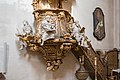
Klosterkirche pulpit
more pictures
Klosterkirche organ
more pictures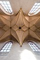
Abbey church ceiling vaults
more pictures
Kartäuserstraße 5
more pictures
Konventstraße 2, 4, 6
more pictures
Konventstraße 4, 6
more pictures
Konventstraße 6, 8
more pictures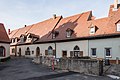
Konventstraße 6, 8
more pictures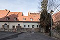
Konventstraße 8, 10
more pictures
Konventstraße 14
more pictures
Konventstraße 16
more pictures
Konventstraße 18
more pictures
Konventstrasse 20, 22, 24
more pictures
Konventstraße 5
more pictures
Kartäuserstraße 1, commercial wing,
more pictures
Kartäuserstraße 1, commercial wing,
more pictures
Kartäuserstraße 1, commercial wing,
more pictures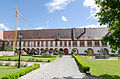
Schloßhof 5, 7
more pictures
Schloßhof 7
more pictures


Zeubelried
| location | object | description | File no. | image |
|---|---|---|---|---|
| Birkenstrasse 2 ( location ) |
Wayside shrine | Canopy-crowned relief attachment with Pietà group and saints, on pillars with saints reliefs above pedestal, sandstone, late 18th century | D-6-79-170-390 | |
| Fichtenstrasse; in the village ( location ) |
Wayside shrine | with reliefs of the Trinity and fourteen saints, late 18th century | D-6-79-170-389 | |
| Fichtenstrasse 3 ( location ) |
Catholic parish church of Saint Blaise | Hall building with retracted choir and choir tower with pointed helmet, with wooden figure of the church patron above the north portal, this probably in the middle of the 14th century, built at the end of the 13th century, the nave changed in the 18th century; with equipment | D-6-79-170-384 | |
| Fichtenstrasse 3 ( location ) |
Mount of Olives Chapel | with late Gothic wooden sculptures, late 15th century | D-6-79-170-384 | |
| Fichtenstrasse 3; at the church ( location ) |
crucifix | Remnants of a Christ corpus destroyed in World War II, sandstone, 18th century | D-6-79-170-388 | |
| Lindenstrasse; at the property wall ( location ) |
Picture house | Round-arched niche with a group of figures of the Holy Family, 19th century | D-6-79-170-387 | |
| Lindenstrasse 19 ( location ) |
Residential buildings | two-storey, plastered mansard roof building with half-timbered upper storey, late 18th century | D-6-79-170-385 | |
| Lindenstrasse 21 ( location ) |
barn | Half-timbered building with mansard roof, 18th / 19th centuries Century; Entrance to the courtyard, around 1800 | D-6-79-170-386 | |
| Sulzfelder Weg; on the road to Sulzfeld ( location ) |
Wayside shrine | with Pietà relief, 1st half of the 17th century | D-6-79-170-391 |
Former architectural monuments
This section lists objects that were previously entered in the list of monuments.
| location | object | description | File no. | image |
|---|---|---|---|---|
| Ochsenfurt Spitalgasse 7 ( location ) |
Gabled house | Upper floor half-timbered plastered, in the core 16th century | D-6-79-170-179 | |
| Ochsenfurt State Road 2269; Country road to Aub, after the junction from Uffenheimer Straße ( location ) |
Wayside shrine | with St. Michael, probably 17th century | D-6-79-170-240 |
See also
Remarks
- ↑ This list may not correspond to the current status of the official list of monuments. The latter can be viewed on the Internet as a PDF using the link given under web links and is also mapped in the Bavarian Monument Atlas . Even these representations, although they are updated daily by the Bavarian State Office for Monument Preservation , do not always and everywhere reflect the current status. Therefore, the presence or absence of an object in this list or in the Bavarian Monument Atlas does not guarantee that it is currently a registered monument or not. The Bavarian List of Monuments is also an information directory. The monument property - and thus the legal protection - is defined in Art. 1 of the Bavarian Monument Protection Act (BayDSchG) and does not depend on the mapping in the monument atlas or the entry in the Bavarian monument list. Objects that are not listed in the Bavarian Monument List can also be monuments if they meet the criteria according to Art. 1 BayDSchG. Early involvement of the Bavarian State Office for Monument Preservation according to Art. 6 BayDSchG is therefore necessary in all projects.
- ↑ City fortification Ochsenfurt ( Memento of the original from February 22, 2014 in the Internet Archive ) Info: The archive link was inserted automatically and not yet checked. Please check the original and archive link according to the instructions and then remove this notice. at the Bavarian State Office for Monument Preservation
- ↑ Gerhard Meissner: With the Fröhlich wine bar, an inn steeped in tradition closes its doors forever. In: Main-Post from April 11, 2010 .
literature
- Denis André Chevalley: Lower Franconia . Ed .: Michael Petzet , Bavarian State Office for the Preservation of Monuments (= Monuments in Bavaria . Volume VI ). Oldenbourg, Munich 1985, ISBN 3-486-52397-X .
Web links
- Bavarian Monument Atlas (cartographic representation of the Bavarian architectural and ground monuments by the Bavarian State Office for Monument Preservation (BLfD) )
- List of monuments for Ochsenfurt (PDF) at the Bavarian State Office for Monument Preservation

Altertheim | Aub | Bergtheim | Bieberehren | Bütthard | Eibelstadt | Eisenheim | Eisingen | Erlabrunn | Estenfeld | Frickenhausen am Main | Gaukönigshofen | Gelchsheim | Gerbrunn | Geroldshausen | Gable City | Greußenheim | Güntersleben | Hausen near Würzburg | Helmstadt | Hettstadt | Höchberg | Wooden churches | Kirchheim | Box | Small cattle field | Kürnach | Leinach | Margetshöchheim | Neubrunn | Oberpleichfeld | Ochsenfurt | Prosselsheim | Randersacker | Reichenberg | Remlingen | Riedenheim | Rimpar | Rottendorf | Röttingen | Sommerhausen | Sonderhofen | Tauberrettersheim | Theilheim | Thüngersheim | Uettingen | Unterpleichfeld | Veitshoechheim | Waldbrunn | Waldbüttelbrunn | Winterhausen | Zell am Main