
List of ponds of the Freiberg Revierwasserlaufanstalt
The ponds of the Freiberg Revierwasserlaufanstalt currently comprise eleven 1 smaller and larger reservoirs , eight of which can be assigned to the reservoirs due to their size . They were created from 1557/1558 as artificial ponds in the Freiberg area , when dewatering in mining made it necessary to bring in ever larger amounts of water. After mining stopped, the Constantine Pond was created as the upper basin of the Dreibrüderschacht cavern power station . The reservoirs are now operated by the state dam administration of Saxony .
Table of ponds
BWV = industrial water supply , F = fishing , HWS = flood protection , K = hydropower , NEG = recreation area , NSG = Nature Reserve , TWV = drinking water supply , FFH = Fauna Flora Habitat
| Surname | part the |
Coordinates | height |
construction time | Dam- length |
Traffic jam- space |
surface (Ha) |
Todays use |
|---|---|---|---|---|---|---|---|---|
| Dittmannsdorfer pond | Upper | 50 ° 42 ′ 1 ″ N , 13 ° 23 ′ 31 ″ E | 571.6 | 1826-1828 | 282 | 0.459 | 10.6 | BWv, HWS, K, F, FFH |
|
Mine pond (Beer meadow pond) 2 |
Upper | 50 ° 42 ′ 22 " N , 13 ° 21 ′ 38" E | approx. 565 | 1813 | 0.010 | 1.0 | BWv; since 1997 at RWA | |
| Dörnthal pond | Upper | 50 ° 43 ′ 31 ″ N , 13 ° 20 ′ 27 ″ E | 561.8 | 1787-1790, 1842-1844 |
300 | 1.215 | 19.5 | TWv, HWS, F, FFH |
| Obersaida pond | Upper | 50 ° 46 ′ 15 " N , 13 ° 20 ′ 10" E | 550.2 | 1728-1734 | 214 | 0.128 | 5.7 | TWv, HWS, F, FFH |
| Upper Großhartmannsdorfer pond | Upper | 50 ° 47 ′ 2 " N , 13 ° 19 ′ 35" E | 534.6 | 1591–1593, rebuilt several times |
531 | 0.966 | 21.2 | TWv, BWV, HWS, F, FFH |
|
Land pond (Praised Lander Pond) |
Upper | 50 ° 51 ′ 0 ″ N , 13 ° 19 ′ 6 ″ E | 507.5 | before 1570 | 474 | 0.019 | 3.8 | F; no longer to RWA |
| Middle Großhartmannsdorfer pond | Lower | 50 ° 48 ′ 24 " N , 13 ° 19 ′ 11" E | 504.7 | 1726-1732 | 632 | 0.908 | 12.1 | BWv, NEG, F |
|
Lower Großhartmannsdorfer pond (Tenth pond) |
Lower | 50 ° 48 ′ 30 " N , 13 ° 20 ′ 22" E | 492.0 | before 1524, 1568-1572 |
494 | 1.680 | 61.0 | BWv, F, NSG, FFH |
| Archangel pond | Lower | 50 ° 51 ′ 8 ″ N , 13 ° 20 ′ 22 ″ E | 496.1 | 1569-1570 | 204 | 0.176 | 8.0 | BWv, HWS, NEG, F |
| Rothbach pond | Lower | 50 ° 51 '24 " N , 13 ° 20' 40" E | 482.8 | 1568-1596 | 248 | 0.096 | 2.8 | BWv, F, FFH |
|
Lother pond (Mill pond) |
Lower | 50 ° 51 '34 " N , 13 ° 20' 49" E | 470.0 | around 1568 | 104 | 0.044 | 2.4 | TWv; no longer to RWA |
| Constantine Pond | Lower | 50 ° 52 ′ 33 " N , 13 ° 20 ′ 27" E | 475.1 | around 1580, 1912-1913 |
498 | 0.035 | BWv | |
|
Hut pond (Large hut pond) |
Lower | 50 ° 52 ′ 34 " N , 13 ° 21 ′ 33" E | 446.1 | 1558-1560 | 443 | 0.325 | 16.0 | BWv, HWS, F, FFH |
The electoral mine ponds also included the Rotvorwerksteich , which was laid out in the 16th century and supplied pits in the upper part of St. Michaelis with impact water. After its five springs were tapped by the mine, it gave luck behind the three crosses at the beginning of the 19th century, and it lost its importance as a mining pond.
more ponds
In the Freiberg mountain area there are numerous other ponds that are related to mining but did not belong to the RWA:
- Oberer and Unterer Pochwerksteich, formerly Himmelsfürster Teiche , Langenau , originated in 1570
- Großer Teich (Freiberg) , also called Soldatenteich, bathing pond
- Mittelteich , Stadtwald Freiberg, was created in the 15th century
- Erzwäsch, Freiberg
- Zechenteich , large umbrella company, was established around 1600
- New pond , also known as Kühschacht pond, was built between 1680 and 1682, broken in 1839
gallery
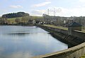
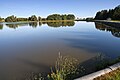
Dittmannsdorfer pond
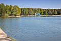
Archangel pond

Hut pond
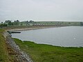
Upper Großhartmannsdorfer pond

Middle Großhartmannsdorfer pond

Lower Großhartmannsdorfer pond

Constantine Pond
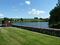
Obersaida pond
Rothbach pond
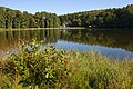
Lower punch pond


See also
literature
- Mining Association of Freiberg (Ed.): Freiberg's mining and smelting system . A brief description of the orographic, geological, historical, technical and administrative conditions. 1st edition. Craz & Gerlach, Freiberg 1883, p. 97-107 ( Textarchiv - Internet Archive ).
- Otfried Wagenbreth : The Freiberg mining . Technical monuments and history. Ed .: Eberhard Wächtler . 2nd Edition. German publishing house for basic industry, Leipzig 1988, ISBN 3-342-00117-8 , p. 62-72, 248-252 .
Individual evidence
- ↑ Königliche Bergakademie zu Freiberg (Hrsg.): Yearbook for the mountain and hut man to the year 1869 . Craz & Gerlach, Freiberg 1869, p. 82 ( tu-freiberg.de [PDF; 1.3 MB ; accessed on December 22, 2012]). tu-freiberg.de ( Memento of the original dated November 9, 2013 in the Internet Archive ) Info: The archive link was inserted automatically and has not yet been checked. Please check the original and archive link according to the instructions and then remove this notice.