Luisino Údolí (Deštné v Orlických horách)
| Luisino Údolí | ||||
|---|---|---|---|---|
|
||||
| Basic data | ||||
| State : |
|
|||
| Region : | Královéhradecký kraj | |||
| District : | Rychnov nad Kněžnou | |||
| Municipality : | Deštné v Orlických horách | |||
| Geographic location : | 50 ° 17 ' N , 16 ° 23' E | |||
| Height: | 876 m nm | |||
| Residents : | ||||
| Postal code : | 517 91 | |||
| License plate : | H | |||
| traffic | ||||
| Street: | Deštné v Orlických horách - Zdobnice | |||
Luisino Údolí (German Luisenthal ) is a settlement of the municipality Deštné v Orlických horách in the Czech Republic . It is located three and a half kilometers southeast of Deštné v Orlických horách on the district Jedlová v Orlických horách and belongs to the Okres Rychnov nad Kněžnou .
geography
The mountain settlement Luisino Údolí is located at the southern foot of the Velká Deštná (1115 m nm) on a saddle in the Eagle Mountains on the road II / 310 between Deštné v Orlických horách and Zdobnice . To the north-east rises the Maruša ( Maruscha , 1042 m nm), in the east the Jelenka ( Lotzenberg , 1083 m nm) and the Koruna ( Kreiselberg , 1101 m nm), southeast of the Vapenný vrch (952 m nm), in the south of the Lubný ( Karlslehne , 956 m nm), to the west of the Ovčár (707 m nm) and in the northwest of the Studený vrch (883 m nm).
Neighboring towns are Šerlich and Destinationsiec in the north, Trčkov and Bedřichovka in the north-east, Zelenka , Jadrná and Kunštát in the east, the desert of Anenská Huť in the south-east, Kamenec , Zdobnická Seč, Kačerov, Zámeček and Podolí in the south, Zálesíť Huť and in the south , Jedlová v Orlických horách in the west and Zákoutí in the northwest.
history
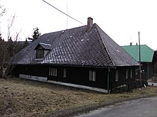
The lumberjack settlement Luisenthal was created in 1828 by the owner of the Solnitz rule , Anton Ritter Sliwka von Sliwitz, in the forests belonging to the Tanndorf corridor and is named after his mother. The village is not yet mentioned in the description of the Königgrätzer Kreis from 1836. Until the middle of the 19th century, the village remained subject to the allodial rule of Solnitz.
After the abolition of patrimonial Luisenthal formed from 1849 a district of the community Tanndorf in the judicial district of Reichenau . From 1868 the village belonged to the Senftenberg district , in 1869 it was assigned to the Rokitnitz judicial district . After the establishment of Czechoslovakia, Luisenthal was given the official Czech name Luisino Údolí . In the 1921 census, 53 Germans lived in the 12 houses of the settlement. In 1930 there were 37 people living in Luisenthal . After the Munich Agreement , the settlement was added to the German Reich at the end of 1938 and belonged to the German district of Grulich until 1945 .
After the end of the Second World War, the settlement came back to Czechoslovakia. The German residents were expelled ; a large part of Luisino Údolí's houses remained uninhabited afterwards. In 1949 Luisino Údolí was incorporated together with Jedlová to Deštné and assigned to the Okres Dobruška. In 1950 Luisino Údolí only had five residents. In the course of the territorial reform of 1960, the Okres Dobruška was repealed and Luisino Údolí was assigned to the Okres Rychnov nad Kněžnou . Luisino Údolí consists entirely of wooden houses that are now used as holiday and weekend homes.
Attractions
- Timbered houses
- Forester's house
Web links
- Description in Adlergebirge / Orlické hory p. 577
- Description on orlickehory.net
- Description of the location of Tanndorf and Luisenthal on the website of the Adlergebirge Heimatverein
Individual evidence
- ^ Johann Gottfried Sommer , Franz Xaver Maximilian Zippe: The Kingdom of Böhmen. Statistically and topographically presented, vol. 4 Königgrätzer Kreis , Prague 1836, p. 266
- ↑ Chytilův místopis ČSR, 2nd updated edition, 1929, p. 1319 Údolí Losové - Úhelnice


