Jedlová v Orlických horách
| Jedlová v Orlických horách | ||||
|---|---|---|---|---|
|
||||
| Basic data | ||||
| State : |
|
|||
| Region : | Královéhradecký kraj | |||
| District : | Rychnov nad Kněžnou | |||
| Municipality : | Deštné v Orlických horách | |||
| Area : | 1238.4202 ha | |||
| Geographic location : | 50 ° 18 ' N , 16 ° 21' E | |||
| Height: | 712 m nm | |||
| Residents : | ||||
| Postal code : | 517 91 | |||
| License plate : | H | |||
| traffic | ||||
| Street: | Skuhrov nad Bělou - Deštné v Orlických horách | |||
Jedlová v Orlických horách (German Tanndorf ) is a basic settlement unit of the municipality Deštné v Orlických horách in the Czech Republic . It is located one and a half kilometers south of Deštné v Orlických horách and belongs to the Okres Rychnov nad Kněžnou .
geography
The scattered settlement Jedlová v Orlických horách extends to the left of the Bělá ( Alba ) at the confluence of the small water at the western foot of the Eagle Mountains ridge . The road II / 321 between Skuhrov nad Bělou and Deštné v Orlických horách runs through the village . To the north rises the Kamenný vrch (1037 m nm), in the northeast of the Šerlich (1027 m nm) and the Malá Deštná (1090 m nm), to the east the Velká Deštná (1115 m nm), the Maruša (1042 m nm) and the Studený vrch (883 m nm), in the southeast of the Lubný ( Karlslehne , 956 m nm), south of the Ovčár (707 m nm), in the west of the Dříšský kopec (726 m nm) and northwest of the Plasnický Špičák (833 m nm)
Neighboring towns are Deštné v Orlických horách in the north, Zákoutí in the northeast, Luisino Údolí in the east, Zálesí and Kamenec in the southeast, Hutě, Stará Huť and Podolí in the south, Mnichová, Stará Náves and Strakovec in the southwest, Rovenské Šediviny and Práz in the west Kout and Dříš in the northwest.
history
Tanndorf was probably founded as a logging settlement by the Lords of Dobruška . The village was first mentioned in documents in 1362 when the Lords of Dobruška left it to the Heiligenfeld Monastery . A little later, the Heiligenfeld Cistercians built a monastery courtyard in the Deschney corridor . After the fall of the monastery in the Hussite Wars, the village came to secular owners and finally to the rule of Solnitz . In 1515 Tanndorf was separated from Deschney and received its own local jurisdiction. Around 1612, on the cleared Obschar ridge above the village, a St. The little wooden church consecrated to Matthew was erected. Vratislav Eusebius von Pernstein's sister Febronia Eusebia Helena von Pernstein bequeathed the Solnitz rule to the Carmelite monastery on Prague's Lesser Town in 1646 after her family had died out . In the 18th century the village was greatly expanded, and the Obschar settlement was built around the church. In 1726 the church was assigned to the Deschney parish as a branch church. The old church was demolished in 1736. In the years 1737–1741 a new stone building was built in its place. After the abolition of the Carmelite order, the Solnitz estate was assigned to the kk religious fund. The Hüttendorf settlement was separated from Tanndorf in 1821 and connected to Groß Auerschim. In 1825 the Solnitz rule was sold to Anton Ritter Sliwka von Sliwitz. In 1828 he had the Luisenthal settlement built in the corridors of Tanndorf .
In 1836 the village of Tanndorf or Gedlowa in the Königgrätzer Kreis consisted of 95 houses in which 653 predominantly German-speaking people lived. The houses surrounded by forest were scattered in the valley of the Albabach and on the mountains; two locations were designated as Dreihäusel and Obschar and Občar . The branch church of St. Matthew and the school in the Obschar were under official patronage. There were also two taverns, two mills - the back mill and the mansion mill - and board saws. The parish office was Deschney . Until the middle of the 19th century, the village remained subject to the allodial rule of Solnitz.
After the abolition of patrimonial , Tanndorf formed a community in the judicial district of Reichenau from 1849 with the districts of Annahütte and Luisenthal . From 1868 the village belonged to the Senftenberg district , in 1869 it was assigned to the Rokitnitz judicial district . The Karolinenhütte, operated by the landlords of Solnitz from 1873 to 1910 in the Tanndorfer Hinterwinkel, was the last glassworks in the Eagle Mountains. Another single-class elementary school was opened in Tanndorfer Hinterwinkel in 1890. At that time there were almost 1000 people in the community. In 1895 Annahütte was reassigned to Groß Auerschim. At the beginning of the 20th century the village developed into a road junction, from which roads led in five directions into the mountains and foreland. In the elementary school on the Obschar the two-class teaching was started before 1918, it became a single-class elementary school again in 1926 due to the decline in the number of pupils. The permanent branches of Michowie (from 1925) and Lom (from 1938) belonged to the Tanndorf branch church. In 1930 there were 499 people living in the community of Tanndorf (with Louisenthal). At that time there was a power station, a dairy, a furniture factory, a flax crusher, a beekeeping and weaving mills in Tanndorf. After the Munich Agreement , the municipality was added to the German Reich at the end of 1938 and belonged to the German district of Grulich until 1945 . In 1939 the community had 474 inhabitants and consisted of 140 houses. The village corridor extended over an area of 782 hectares to the mountain ridge (1050 m nm). The primary school in Tanndorfer Hinterwinkel was closed in 1939.
After the end of the Second World War, the community came back to Czechoslovakia and received the official name Jedlová . The German residents were expelled. Most of the houses in Jedlová remained uninhabited and fell into disrepair. In 1949 Jedlová was incorporated into Deštné and assigned to Okres Dobruška; at the same time, the district received the official name Jedlová v Orlických horách . In the course of the territorial reform of 1960, the Okres Dobruška was repealed and Jedlová was assigned to the Okres Rychnov nad Kněžnou . In the second half of the 20th century, most of the abandoned houses were demolished and a small number found new uses as holiday homes. On March 1, 1980 Jedlová v Orlických horách lost the status of a district.
Today Jedlová v Orlických horách is a summer resort and winter sports area. On the northern slope of Studenný vrch there are numerous downhill routes with lifts. 2006 at Skicentrum Deštné the two-seater Doppelmayr - chairlift Valachovka-Studenný taken vrch in operation, previously considered since 1980 Tälilift in the winter sports resort of Malbun was established. There is also a ropes course in Jedlová ( Lanový park Deštné ).
Local division
The basic settlement unit Jedlová v Orlických horách forms a cadastral district. In addition to Jedlová, it also includes the Luisino Údolí ( Luisenthal ) settlement and the locations of Ovčár ( Obschar ), Stará Huť ( Althütte ) and Zálesí ( Dreihäusel )
Attractions
- Church of St. Matthäus, built 1737–1741 instead of a previous wooden building, was completed by Donatius Theodor Morazzi. The church, left to decay, was partially repaired after 1989 by the DCŽM Vesmír and saved from demolition. The church is surrounded by a cemetery.
- Mlýn u Skály , a former water mill on the Bělá
- former Karolinenhütte glassworks , on the road to Zákoutí
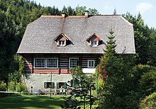
- Several folk-style houses
- Niche chapel
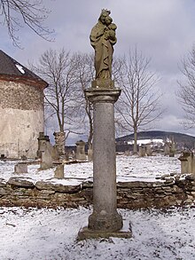
- Marian column at the cemetery
Sons and daughters of the place
- Hieronymus Brinke (1800–1880), chronicler and poet, creator of the "Weber song"
Web links
- History of Deštné v Orlických horách
- Location description on the website of the Adlergebirge home association
Individual evidence
- ↑ http://www.uir.cz/katastralni-uzemi/625833/Jedlova-v-Orlickych-horach
- ^ Johann Gottfried Sommer , Franz Xaver Maximilian Zippe: The Kingdom of Böhmen. Statistically and topographically presented, vol. 4 Königgrätzer Kreis , Prague 1836, p. 266
- ^ Michael Rademacher: German administrative history from the unification of the empire in 1871 to the reunification in 1990. Grulich district. (Online material for the dissertation, Osnabrück 2006).
- ↑ http://www.lanove-drahy.cz/?page=lan&lan=61
- ↑ http://www.lanovyparkdestne.cz/


