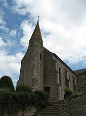
Luitré
| Luitré | ||
|---|---|---|
|
|
||
| local community | Luitre-Dompierre | |
| region | Brittany | |
| Department | Ille-et-Vilaine | |
| Arrondissement | Fougères-Vitré | |
| Coordinates | 48 ° 17 ′ N , 1 ° 7 ′ W | |
| Post Code | 35133 | |
| Former INSEE code | 35163 | |
| Incorporation | 1st January 2019 | |
| status | Commune déléguée | |
| Website | http://www.luitre.fr/ | |
 Luitré town hall |
||
Luitré ( Breton : Loezherieg ; Gallo : Lutraé ) is a town and commune Déléguée in the French community Luitré-Dompierre with 1,295 inhabitants (as of January 1 2017) in the department of Ille-et-Vilaine in the region of Brittany . The inhabitants are called Luitréens .
On January 1, 2019, the municipality of Luitré merged with Dompierre-du-Chemin to form the Commune nouvelle Luitré-Dompierre. It belonged to the arrondissement Fougères-Vitré and was part of the canton Fougères-2 (until 2015: canton Fougères-Nord ).
geography
Luitré is about ten kilometers southeast of Fougères . The municipality of Luitré was surrounded by the neighboring municipalities of La Selle-en-Luitré and La Chapelle-Janson in the north, Saint-Pierre-des-Landes in the east, Juvigné in the southeast, Princé and Dompierre-du-Chemin in the south, Parcé in the west and Southwest and Javené in the west and northwest.
Population development
| year | 1962 | 1968 | 1975 | 1982 | 1990 | 1999 | 2006 | 2013 |
| Residents | 1,191 | 1,154 | 1.010 | 1,160 | 1,258 | 1,186 | 1,261 | 1.306 |
|
Source: INSEE
|
||||||||
Attractions
- Saint-Martin church, Romanesque tower from the 12th century
- Monumental cross from the 16th century, Monument historique
- Montbelleux colliery
Community partnerships
There is a partnership with the Polish municipality of Przygodzice in Greater Poland.
literature
- Le Patrimoine des Communes d'Ille-et-Vilaine. Flohic Editions, Volume 1, Paris 2000, ISBN 2-84234-072-8 , pp. 617-619.

