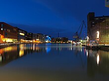
Münster-Hansaviertel
The Hansaviertel (also Hafen-Neustadt or Hafenviertel ) is a district in Münster , located in the eastern part of the Mitte district , around the former city harbor . In the official regional breakdown, it corresponds to the statistical districts of Hansaplatz and Hafen .
The Hansaviertel is delimited by the railway lines of the main train station in the west, by Wolbecker and Sternstrasse in the north, by the Hohenzollernring, Schillerstrasse and Dortmund-Ems Canal in the east, and by the industrial area on Industrieweg beyond the port in the south. In the west the Hansaviertel borders the Bahnhofsviertel, in the north on the Mauritzviertel , in the east on the Herz-Jesu-Viertel and in the southeast on Gremmendorf . As of December 2014, the Hansa and port districts had 7,977 inhabitants (statistical district Hansaplatz: 6932; port: 1045).
history
Until well into the 19th century, Münster was limited to the area of the old town, which is now separated from the promenade. The area of today's Hansaviertel was at the gates of the city and belonged partly to the municipality of St. Mauritz , partly to the Delstrup farmers of the municipality of Lamberti . The city harbor was inaugurated in 1899 as part of the Dortmund-Ems Canal . Soon afterwards, warehouses, storage areas and factories sprang up all around. The gas works was also here. In 1875 the part of the municipality of St. Mauritz closest to the city center was incorporated into Münster, and in 1903 the area around the port was also incorporated. The residential area between the main train station and Hansa or Hohenzollernring was created in the first years of the 20th century in the typical multi-storey perimeter block development of the Wilhelminian era .
character
The Hansa and harbor district was dubbed “ In-Quartier ” in the 2000s and is cited as an example of gentrification in Münster .
Hansaplatz
The part closest to the city center, between the main train station, Wolbecker Straße and Ring, is mainly residential. However, the central Hansaring and Wolbecker Straße are also popular nightlife areas with a number of dining options (restaurants, cafes, bars and pubs) and specialized retail outlets. The center and namesake of this area is Hansaplatz at the intersection of Wolbecker Straße and Hansaring.
port
In the center of the Hansaviertel is the former city port I. After shipping traffic and the associated logistics tasks had decreased significantly here in the 1980s, alternative companies and a discotheque initially settled in the empty warehouses. In the 1990s, the city of Münster then planned a development into a communication and media center under the heading “Kreativkai”. At the so-called waterfront , some of the port buildings have been refurbished into residential buildings and some have been supplemented by new buildings. In addition, there is practically one catering establishment after the next on the harbor promenade, making it a popular destination, especially for going out in the evening. At or in the immediate vicinity of the port is the seat of Stadtwerke Münster , the Wolfgang Borchert Theater , the Kunsthalle Münster and the city's largest multiplex cinema.
At the Hawerkamp
At Hawerkamp - the site of a former concrete factory - there are various facilities of the alternative cultural scene: mainly discos and nightclubs, but also studios and rehearsal rooms. In addition, the Vainstream Rockfest has been taking place annually in the immediate vicinity since 2006 .
In Münster's application for European Capital of Culture 2010, the Hawerkamp was one of the cultural focal points alongside the Prinzipalmarkt and the Picasso Museum .
Since January 1, 2006, the Hawerkamp area has been managed independently by the “Get the Hawerkamp” association. The area is legally considered a commercial area.
traffic
The main traffic routes in the Hansaviertel are Wolbecker Strasse and Albersloher Weg, which are arterial roads from the city center to the east and south-east. The city bus routes 11, 14 and 22 (Wolbecker Straße) and 6, 8 and 17 (Albersloher Weg) run on them, supplemented by the ring route 33/34 on the Hansaring. In night traffic, the Hansaviertel is served by the N84 (Wolbecker Straße) and N85 (Albersloher Weg).
Web links
- Hansaviertel Münster , presentation on the website of the city of Münster
Individual evidence
- ↑ City of Münster: Small-scale regional structure - 45 districts (statistical districts). As of December 31, 2015.
- ↑ City of Münster: Population entitled to reside in the city districts (statistical districts) on December 31 , 2014 ( Memento of the original from November 27, 2016 in the Internet Archive ) Info: The archive link has been inserted automatically and has not yet been checked. Please check the original and archive link according to the instructions and then remove this notice.
- ↑ a b Jürgen Kehrer: Instructions for use for Münster and the Münsterland. Piper, Munich 2011.
- ^ Christian Krajewski: Gentrification in residential areas close to the city center. The Kreuzviertel in Münster. In: Westfalen Regional , 2007, pp. 126–127.
- ↑ a b c d Ingo Steinke: The Hansaviertel in Münster. ( Memento of the original from September 20, 2016 in the Internet Archive ) Info: The archive link was inserted automatically and has not yet been checked. Please check the original and archive link according to the instructions and then remove this notice. In: Münster.de , accessed on November 26, 2016.
Coordinates: 51 ° 57 ' N , 7 ° 39' E


