Maiberg (Cottbus)
|
Maiberg
Majberk City of Cottbus
Coordinates: 51 ° 51 ′ 0 ″ N , 14 ° 19 ′ 48 ″ E
|
|
|---|---|
| Postal code : | 03054 |
| Area code : | 0355 |
|
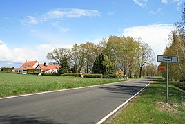
West entrance to the village
|
|
Maiberg , Majberk in Lower Sorbian , is a residential area in the Döbbrick district of the city of Cottbus in Lower Lusatia in Brandenburg .
geography
The small village in Niederlausitz is located directly on the Spree , a good three kilometers north of Döbbrick and about ten kilometers north of Cottbus. The river coming from the south turns here on the southern edge of the village towards the west into the Glogau-Baruther glacial valley and has been part of the FFH area and the Spreeaue nature reserve of the same name since 2003 . On the south side of this Spreebogen , also called Cottbuser Spreeaue , extensive and extensive renaturation has been carried out since 2007, with the aim of restoring a lost natural meadow landscape .
On the eastern edge of Maiberg are the Laßzinswiesen , which are partly part of the FFH area and the Peitzer Teiche nature reserve . This open and hardly cut up wet landscape, mainly used as meadow and pasture, is drained via an extensive ditch system. The two largest, the Schwarze Graben and the Teichgraben , flow towards the Hammergraben , which crosses the town in the north in a westerly direction. The village belongs to the Oberspreewald in the natural area Spreewald and the European bird sanctuary Spreewald and Lieberoser terminal moraine in the northeast German lowlands.
Neighboring towns are Aue in the north, Drehnow , Turnow , Expansion Windmühle and Peitz in the northeast, Mouse , Döbbrick Ost and Döbbrick in the southeast, Masnick's Häuslergut in the south, Sielow , Dissen and Striesow in the southwest, Fehrow in the west and Forsthaus Tannenwald and Sand in the northwest.
history
There is evidence that the Dammmeister house at Maiberg was moved into here in 1788 , a piece of land belonging to the Maiberg colony . For the settlement, which at that time already belonged to the village of Döbbrick, the construction of further farmsteads in 1800 is documented. At that time still located in the Markgraftum Niederlausitz , the place came to Prussia in 1815 and became part of the Frankfurt administrative district of the Brandenburg province ; from 1818 then part of the Cottbus district.
In the years 1821/22 plans were drawn up to build a canal west of the Maiberger Spreebogen towards the north to the Schwielochsee about 12 kilometers away . Presumably because of a lack of acceptance and a lack of donors, this project was never realized. In the years 1826 and 1832 further farmsteads were built in the village and in 1935 there were a total of 28 farmsteads and 137 inhabitants. From 1952 the village belonged to the Cottbus-Land district , and from 1990 back to the Cottbus district.
On December 6, 1993, the Cottbus district was dissolved, Maiberg came to Cottbus and thus became the city's northernmost settlement.
Attractions
In the center of the town, not far from the junction of the road to Drehnow , there is a memorial to the townspeople who died in World War 1914–1918.
Web links
- Maiberg, Majberk in the historical directory of the association for computer genealogy
Individual evidence
- ^ District-free city of Cottbus - districts according to § 45 municipal constitution - living spaces. In: service.brandenburg.de. Ministry of the Interior and Local Affairs of the State of Brandenburg, accessed on May 4, 2016 .
- ^ Federal Agency for Nature Conservation: Location of Maiberg according to Geospatial services. Protected areas in Germany. Retrieved May 4, 2013 .
- ↑ BrandenburgViewer of the state survey and geographic base information Brandenburg (LGB)
- ↑ a b Rudolf Lehmann: Historical local dictionary for Niederlausitz. In: Volume 2. Brandenburgisches Landeshauptarchiv, 2011, p. 73 , accessed on May 4, 2013 .
- ↑ Wolfgang Rolland, Ingolf Arnold: Lower Lusatia from the 18th century to today: a disturbed cultural landscape? Günter Bayerl, Dirk Maier, 2002, p. 218 , accessed on May 4, 2013 .
- ^ Frank Henschel: Online project fallen memorials. By genealogists for genealogists. Thilo C. Agthe, January 2009, accessed May 4, 2013 .
