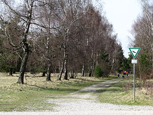
Mallertshofer wood with heathers
|
Nature reserve "Mallertshofer Holz mit Heiden"
|
||
|
Path on the western edge of the area north of St. Martin's Church |
||
| location | Oberschleissheim , Munich District , Upper Bavaria , Bavaria , Germany | |
| surface | 6.094 km² | |
| Identifier | NSG100.126 | |
| WDPA ID | 164561 | |
| Natura 2000 ID | [http://formulare.landkreis-muenchen.de/cdm/cfs/eject/gen?MANDANTID=1&FORMID=4112 DE-7735-371 DE-7735-371 ] | |
| Geographical location | 48 ° 16 ' N , 11 ° 37' E | |
|
|
||
| Setup date | 10/20/1995 | |
| administration |
Government of Upper Bavaria, Section 51 - Nature Conservation ; Maintenance by the Heath Area Association Munich North eV |
|
The nature reserve Mallertshofer Holz mit Heiden is located in the area of the municipality of Eching in the district of Freising and the city of Garching and the municipality of Oberschleißheim in the district of Munich . It has existed since 1995, is registered under the registration number NSG-00501.01 and has a size of 609.42 hectares.
These are pine forests , heather meadows and open gravel areas with rare animal and plant species. A number of different biotopes have arisen in the former gravel extraction point "Kastner Grube".
development
Around 430 hectares of the current area were used as a military training area for the Bundeswehr and an armored training area. Since 2008, the Federal Agency for Real Estate Tasks had been negotiating with the Garching and Eching municipalities to hand over the land as part of the National Natural Heritage program . In April 2013, the areas were transferred to the municipalities, with care by the Heath Area Association .
A biotope network is being set up with the neighboring nature reserve Garchinger Heide and Echinger Lohe further north . Further south is - on the northern outskirts of Munich (in the area of the city of Munich, the city of Garching and the municipality of Oberschleißheim) - the Fröttmaninger Heide .
Mallertshofen desert
The Mallertshofen desert was a hamlet with two entire courtyards , was first mentioned in a document in the 12th century and gave the Mallertshofer See its name . After a decline in settlement, the small settlement was abandoned around 1880; the remaining rural buildings were demolished. Only the listed church of St. Martin remained , which now stands alone on the eastern edge of the desert. Its origin is dated to the 13th century, the current appearance is determined by renovations and extensions from the 17th century. It is assigned to the parish of St. Korbinian in Lohhof as a side church.
Web links
- Heideflächenverein: Mallertshofer Holz - Brief description of the project
- District Office Freising: The Grasheide. Barren land with great diversity ( Memento from November 8, 2014 in the Internet Archive ) , as of November 2007
- Oberschleißheim, Mallertshofer wood with heaths. Characteristic butterflies with a list of species. In: Day butterflies from Upper Bavaria . Retrieved December 29, 2014 .
Individual evidence
- ↑ Information sheet: "Mallertshofer Holz mit Heiden" nature reserve (NSG-00501.01). (PDF; 218 kB) (No longer available online.) District Office Munich. Subject 6.3 - Nature Conservation, Forest Law and Agriculture Law, 2011, archived from the original on April 5, 2013 ; accessed on January 1, 2014 . Info: The archive link was inserted automatically and has not yet been checked. Please check the original and archive link according to the instructions and then remove this notice.
- ^ Heideflächenverein Münchener Norden eV: Mallertshofer Holz. Retrieved January 8, 2014 .
- ↑ Federal Agency for Real Estate Tasks: Finally official: Mallertshofer Holz is now a national natural heritage , press release of April 22, 2013
- ↑ St. Korbinian, Lohhof: St. Martin side church


