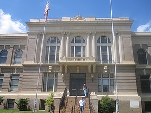
Mansfield (Louisiana)
| Mansfield | ||
|---|---|---|
 The administration building of De Soto Parish |
||
| Location in Louisiana | ||
|
|
||
| Basic data | ||
| State : | United States | |
| State : | Louisiana | |
| Parish : | De Soto Parish | |
| Coordinates : | 32 ° 2 ′ N , 93 ° 42 ′ W | |
| Time zone : | Central ( UTC − 6 / −5 ) | |
| Residents : | 5,001 (as of 2010) | |
| Population density : | 520.9 inhabitants per km 2 | |
| Area : | 9.6 km 2 (approx. 4 mi 2 ) of which 9.6 km 2 (approx. 4 mi 2 ) is land |
|
| Height : | 102 m | |
| Postal code : | 71052 | |
| Area code : | +1 318 | |
| FIPS : | 22-48365 | |
| GNIS ID : | 2405013 | |
| Website : | www.cityofmansfield.net | |
Mansfield is a city and parish seat of De Soto Parish in the US state of Louisiana . About 5000 people live in an area of almost ten square kilometers.
Mansfield is part of the Ark-La-Tex socio-economic region , which includes parts of the four states of Arkansas , Louisiana, Oklahoma, and Texas .
geography
Mansfield is located in northwest Louisiana, about 17 miles from the Texas border. About 25 kilometers southwest of the city is the Sabine National Forest , about 80 kilometers east of the Kisatchie National Forest .
Nearby cities include Grand Cane (9 km northwest), Stonewall (25 km northwest) and Shreveport (40 km north).
history
On April 8, 1864, the Battle of Mansfield was fought under the leadership of General Richard Taylor in Mansfield . That battle withdrew 42,000 soldiers from capturing Shreveport as they moved south to New Orleans . Today the battle is commemorated four kilometers south of town at Mansfield State Historic Site .
In 1855, the first women's college west of the Mississippi River , Mansfield Female College . founded. Financial difficulties and the dangers of war did not allow teaching from 1864 to 1865, the end of the American Civil War . During this time the building served as a hospital for injured soldiers. In 1930 the college was attached to the Centenary College of Louisiana in Shreveport and finally ended its local teaching operations. The building has housed a museum since 2003.
The film The Great Debaters , which appeared in 2007, was partly shot in Mansfield. The film takes place in Marshall , Texas , but was shot in downtown Mansfield. Among others, Denzel Washington and Forest Whitaker participated.
traffic
The city is traversed from west to east by US Highway 84 , which runs from Pagosa Springs , Colorado to Valdosta , Georgia . US Highway 171 runs north to south through the urban area from Shreveport to Lake Charles . Interstate 49 runs from Shreveport to Lafayette about eight miles east of the city .
Demographics
The 2010 census showed a population of 5001 people, divided into 2500 households and 1450 families. The population density was nearly 586 people per square kilometer. 64.3% of the population were black, 34.1% white, 1.6% Hispanic or Latin American, 0.3% Asian, and 0.1% American Indian. 0.5% came from a different ethnicity, 0.8% had two or more ethnicities. The median age was 35 and the per capita income was almost $ 20,000, which means that over a third of the population lived below the poverty line.
Personalities
- Former baseball player Vida Blue was born in Mansfield. He was active in Major League Baseball from 1969 to 1983 and won the World Series three times .
- Joshua Logan , a film and theater director, spent much of his childhood in Mansfield.
- The politician and MP of the United States House of Representatives , Joseph Barton Elam , worked as a lawyer in Mansfield from 1880 until his death.
Web links
- Website of the city of Mansfield (Engl.)
- Statistical data on Mansfield (Engl.)
