Plumb direction


The perpendicular direction is the local direction of the gravitational acceleration , so it points " downwards ".
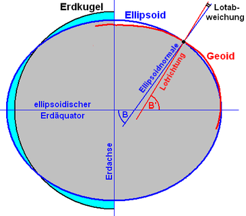
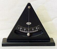
This direction, also called the perpendicular , is perpendicular to the level surfaces of the earth's gravity field in the direction of the resultant from the earth's gravitation and the centrifugal force due to the earth's rotation . Because of the latter, the vertical direction deviates by up to 0.2 ° from the direction in which the center of the earth is located. To determine the local plumb a simple means, the plumb bob .
A straight line in the perpendicular direction at the location , also called vertical or perpendicular , shows the zenith upwards and the nadir downwards as the two points of intersection with the celestial sphere . A straight line or plane at right angles to this is called a horizontal , also horizontal or horizontal . A horizontal plane at the position of the observer is the mathematical horizon (see also tangential plane ).
Physical definition
From a physical point of view, the vertical direction in the gravitational field of the rotating earth is a consequence of gravity and - to a lesser extent - centrifugal force . Therefore it usually does not point to the center of the earth . The rotation (and the resulting centrifugal force and flattening ) causes a deflection that is up to 0.2 ° on Earth and almost 10 ° on Saturn. This amount which is geocentric latitude (with ( psi )) is smaller than the geographical ( , ( beta ) or ( phi )).
More precisely, the perpendicular direction is not a straight line, but a space curve . As a plumb line, it penetrates all level surfaces of the gravitational field orthogonally . The plumb line curvature can be determined by complex measurements (see gravimetry or gradiometry ) or by calculation by modeling the masses of the terrain (topography) and the geological subsurface. The curvature is about 1 ″ in the lowlands , but more than 10 ″ in the high mountains , which is about 0.5 cm (lowlands) to over 5 cm (high mountains) per kilometer.
Astronomical and geographical coordinates
Precise values for astronomical latitude and longitude can be determined from the vertical direction or the position of the zenith in the starry sky . The difference to the geographical latitude and longitude is the so-called vertical deviation , which is caused by the irregularities of the earth's gravity field. They form an important coordinate system for the geosciences - especially geodesy .
On the other hand, the horizon and plumb line form a topocentric horizontal coordinate system , which is of the greatest importance for everyday life and is also called the natural coordinate system .
Measurement and accuracies
The perpendicular direction is measured :
- in the building industry with the plumb line ( plumb ) or bar judges to or 90 ° spirit level and leveling - accuracy of about 0.1 ° to 0,001 °;
- in geodesy with theodolite and special devices such as astrolabe or zenith camera - accuracy 1 "to 0.1" (in connection with plumbing sensors such as dragonflies or compensators );
- in physics with a variety of instruments and accuracies;
- in geodynamics as a vertical fluctuation with special instruments in abandoned tunnels or underground mines (vertical and horizontal pendulum ) to ± 0.01 "and more precisely.
etymology
“Plumb line” is derived from the plumb line, “vertical” from plumb line, “horizontal” presumably from “scales” as a synonym for a water surface in equilibrium - see also spirit level as the original measuring device for this purpose. “Horizontal” refers to the level of the horizon and also has to do with distance vision . In medicine, vertical refers to the line that runs from the top of the head to the sole. "Vertical" comes from the Latin ( vertex " vertex (point)"; the same meaning is based on the "zenith").
literature
- Franz Ackerl : Geodesy and Photogrammetry (= technical manuals for construction practitioners . Vol. 8, ZDB -ID 409611-3 ). 2 volumes. Fromme, Vienna 1950–1956.
- Gottfried Gerstbach : Significance of a geographic information system for earth measurements. In: Gottfried Gerstbach (Ed.): Geoscientific, geotechnical data in land information systems. Needs and opportunities in Austria. Contributions to the GeoLIS conference, 3. – 4. April 1986, Vienna University of Technology (= Geoscientific Communications. Issue 27, ZDB -ID 409611-3 ). Technical University of Vienna - Study of Surveying, Vienna 1986, pp. 9–15.
- Karl Ledersteger : Astronomical and Physical Geodesy (Earth Measurement) (= Handbook of Surveying. Vol. 5). 10th, completely revised and restructured edition. Metzler, Stuttgart 1969.
- Wolfgang Torge : Geodesy. 3rd, completely revised and extended edition. de Gruyter, Berlin et al. 2001, ISBN 3-11-017072-8 .
Web links
- Gravitational field and plumb direction. Technical University of Munich, February 1, 2005, archived from the original on July 2, 2007 ; Retrieved March 7, 2013 .
- Torben Schüler: Calculation of the topographical proportions of vertical deviations. Archived from the original on September 30, 2007 ; accessed on July 15, 2016 .


