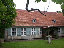
Mirachowo
| Mirachowo | ||
|---|---|---|

|
|
|
| Basic data | ||
| State : | Poland | |
| Voivodeship : | Pomerania | |
| Powiat : | Kartuzy | |
| Gmina : | Kartuzy | |
| Geographic location : | 54 ° 24 ' N , 18 ° 2' E | |
| Residents : | 913 (2005) | |
Mirachowo [ miraˈxɔvɔ ] ( German Mirchau , Kashubian Mirochòwò ) is a village in the urban and rural community of Kartuzy (Karthaus) in the Powiat Kartuski of the Polish Pomeranian Voivodeship .
Geographical location
The place is located in Kashubia in the former West Prussia , about 14 kilometers northwest of Kartuzy and 40 kilometers west of Gdansk .
history
As found bronze grave goods show, the immediate vicinity of the village in Pomerania was already settled in prehistoric times. From 1308 to 1466 Mirochowo or Mirchau belonged to the Teutonic Order of Prussia and then when Prussia was divided into secessionist western Prussia, later also known as the autonomous Prussia Royal Share , which had voluntarily placed itself under the protection of the Polish crown. At that time, Mirchau was the seat of a starost in the Pomeranian Voivodeship formed in 1454 .
After the first partition of Poland in 1772, Pomerania came to the Kingdom of Prussia . From 1818 to 1920 Mirchau belonged to the Prussian district of Karthaus . Around the middle of the 19th century, Mirchau is described as a farming village with a manor and a grinding and cutting mill. In the village there was also a chief forester, a brickworks and a restaurant.
In the last quarter of the 19th century, the village of Mirchau and the Mirchau forest estate were administratively separated from each other.
After the end of the First World War , most of the Karthaus district, including Mirchau, had to be returned to Poland due to the provisions of the Versailles Treaty in January 1920 for the purpose of establishing the Polish Corridor and came to the new Pomeranian Voivodeship . Mirchau still belonged to the Karthaus district, now called Powiat Kartuski , which had been reduced in size by assignments to the Danziger Höhe district.
As a result of the attack on Poland in 1939, the powiat Kartuski with the village of Mirchau came to the Reich territory as occupied Polish territory in violation of international law and was now assigned to the new administrative district of Danzig in the Reichsgau Danzig-West Prussia , which included German and German-occupied Danzig and Polish territory . Towards the end of the Second World War , Mirchau was occupied by the Red Army in January 1945 .
In the following period immigrated German were under German occupation full strength, as well as ancestral German-speaking Poland , provided they had not fled before, mostly from the district sold .
Population development
| year | Residents | Remarks |
|---|---|---|
| 1816 | 168 | |
| 1840 | 411 | in 57 houses, including the manor |
| 1864 | 467 | on December 3, of which 277 in the parish and 190 in the manor district |
| 1871 | 500 | |
| 1905 | 550 |
Parish
The Protestant church in Mirchau was donated by the Gustav-Adolf-Werk around the middle of the 19th century . It was consecrated in 1860. Previously, the Evangelicals in Mirchau had been parish in the Rheinfeld parish.
The village's Catholics belonged to the parish of Sianowo in the 19th century .
Trivia
A criminal case has been recorded in the legal literature in which the murder of a farmer that occurred on the evening of November 10, 1869 near the village of Mirchau was tried.
Web links
- Sierke District (Rolf Jahke, 2004)
- District of Schwanau (Rolf Jahke, 2004)
- Mirchau (Uwe Kerntopf, 1998 ff.)
- Evangelical Church Mirchau (Uwe Kerntopf, 1998 ff.)
Footnotes
- ^ E. Förstemann :: The northern Pomeranian and its antiquities . In: Prussian provincial sheets . AF, Volume 1, Koenigsberg 1852, pp. 133-148, in particular pp. 134-135.
- ^ Anton Friedrich Büsching : Extract from a description of the earth. First part, which contains Europe and the northern part of Asia . Hamburg 1771, pp. 162-166.
- ^ A b Eugen H. Th. Huhn: Topographical-statistical-historical lexicon of Germany . Volume 4, Bibliographical Institute, 1846, p. 413.
- ^ A b Eduard Messow: Topographical-statistical manual of the Prussian state . 1847, p. 78.
- ^ A b Archive for Common German and Prussian Criminal Law . Volume 19, Berlin 1871, pp. 600-504.
- ^ Michael Rademacher: German administrative history from the unification of the empire in 1871 to the reunification in 1990. dan_karthaus.html. (Online material for the dissertation, Osnabrück 2006).
- ↑ Alexander August Mützell and Leopold Krug : New topographical-statistical-geographical dictionary of the Prussian state . Volume 3, Halle 1822, p. 204, item 1964.
- ^ The results of the property and building tax assessment in the administrative district of Gdansk (5th district Krathaus) . Berlin 1867, p. 18, paragraphs 121–122.
- ^ Gustav Neumann: Geography of the Prussian State . 2nd edition, Volume 2, Berlin 1874, pp. 44-45, item 7.
- ↑ http://wiki-de.genealogy.net/GOV:MIRHAUJO94AJ ( page no longer available , search in web archives ) Info: The link was automatically marked as defective. Please check the link according to the instructions and then remove this notice.
- ↑ H. Oelrichs: Statistical communications on the administrative district of Danzig . 1. Continuation, Berlin 1867, p. 64.


