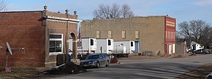
Morse Bluff
| Morse Bluff | |
|---|---|
 Downtown Morse Bluff |
|
| Location in Nebraska | |
| Basic data | |
| Foundation : | 1887 |
| State : | United States |
| State : | Nebraska |
| County : | Saunders County |
| Coordinates : | 41 ° 26 ′ N , 96 ° 46 ′ W |
| Time zone : | Central ( UTC − 6 / −5 ) |
| Residents : | 135 (as of 2010) |
| Population density : | 293.5 inhabitants per km 2 |
| Area : | 0.46 km 2 (approx. 0 mi 2 ) of which 0.46 km 2 (approx. 0 mi 2 ) is land |
| Height : | 391 m |
| Postal code : | 68648 |
| Area code : | +1 402 |
| FIPS : | 31-32865 |
| GNIS ID : | 0831431 |
 St. George Church |
|
Morse Bluff is a village in Saunders County in the state of Nebraska in the United States . The village is located about 20 kilometers west of Fremont on the South Platte River and had a total of 135 inhabitants at the last census in 2010 . Until 1903 the place was called Morse , before it was founded the settlements Benton , Cedar Hill and Sand Creek already existed in the area of Morse Bluff .
history
In 1865 emigrants from Czechoslovakia founded a small settlement south of the South Platt River near the town of North Bend . In 1887, as part of the Chicago & North Western Railroad expansion, the village was founded. The Morse Bluff was named after the landowner Chester Morse. At first the settlement was only called Morse , the name was changed in 1903, as there was already a station with the name Morse along the railway line .
A Catholic church was built near Sand Creek as early as 1880. The settlement was connected to North Bend by a bridge in the same year, the bridge collapsed after a flood in 1912. In 1897 Sand Chreek received a Methodist church. In 1907 Morse Bluff was incorporated as a Village . In 1910 the place was connected to the sewer network, since 1912 the place has been supplied with electricity. In the same year a school was established south of Morse Bluff. Morse Bluff has had another Methodist church since 1914. In the 1920s, the two Methodist parishes of Morse Bluff were united. In the early 1920s there were around a dozen shops in Morse Bluff, in addition to the usual shops such as grocery stores, there was also a cinema and a cement factory. Morse Bluff also had a prison, a bank, a United States Postal Service office, and a town hall.
Several fires broke out in Morse Bluff between 1920 and 1930. In 1945 the St. George Catholic Church was established in Morse Bluff, the construction of the church building that is used today was completed in the early 1950s. In 1952 the school in Morse Bluff was closed. Due to its location, the village was affected by floods several times, the last time in March 2019. Since the road to North Bend was partially damaged by the floods, the students from Morse Bluff who attended schools in North Bend had to walk 100 kilometers a day Go back to school. In 1960 the railway line running through the town was destroyed by flooding, so that the railway operation was finally stopped two years later.
population
| growth of population | |||
|---|---|---|---|
| Census | Residents | ± in% | |
| 1900 | 177 | - | |
| 1910 | 196 | 10.7% | |
| 1920 | 215 | 9.7% | |
| 1930 | 179 | -16.7% | |
| 1940 | 170 | -5% | |
| 1950 | 142 | -16.5% | |
| 1960 | 119 | -16.2% | |
| 1970 | 162 | 36.1% | |
| 1980 | 132 | -18.5% | |
| 1990 | 128 | -3% | |
| 2000 | 134 | 4.7% | |
| 2010 | 135 | 0.7% | |
| US Decennial Census | |||
2010 Census
At the 2010 census, Morse Bluff had 135 people, spread across 58 households and 39 families. Of the population, 99.3% were white and 0.7% were Asian. 2.2% of the population were Hispanics or Latinos . In terms of age, 25.9% of the population were under 18 years old, 11.1% were between 18 and 24, 18.4% between 25 and 44, 30.3% between 45 and 64 and 14.1% were older than 65 years . The median age was 39.3 years. There were children under the age of 18 in 31.0% of households and there were persons over 65 in 10.3% of households. 47.4% of the population were male and 52.6% female.
Census 2000
At the 2000 census , Morse Bluff had 134 residents, spread across 58 households and 40 families. 100.00% of the population were white. Hispanics or Lations made up 1.49% of the total population.
The median income per household in the city at that time was $ 30,625 and the median family income was $ 41,875. 3.0% of the population lived below the poverty line , none of these residents were under 18 and 6.9% were over 65 years old.
Infrastructure
Morse Bluff is on Nebraska Route 79 and two miles south of US Highway 30 .
Web links
Individual evidence
- ↑ Our towns in Nebraska. University of Nebraska-Lincoln, archived from the original on September 23, 2015 ; accessed on September 22, 2019 .
- ^ Census of Population and Housing. United States Census Bureau, accessed September 22, 2019.
