Municipio Turco
| Municipio Turco | ||
|---|---|---|
| Basic data
|
||
| Population (state) - population density |
5207 inhabitants (2012 census) 1 inhabitant / km² |
|
| Post Code | 04-0402 | |
| Telephone code | (+591) | |
| surface | 4,720 km² | |
| height | 3800 m | |
| Coordinates | 18 ° 30 ′ S , 68 ° 28 ′ W | |
|
|
||
| politics
|
||
| Department | Oruro | |
| province | Sajama Province | |
| Central place | Turco | |
| climate | ||
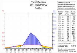
 Climate diagram Turco |
||
The Municipio Turco is a district in the Oruro department in the highlands of the South American Andean state of Bolivia .
Location in the vicinity
The Municipio Turco is the southern of the two Municipios of the Sajama Province . It is bordered to the northwest by the Municipio Curahuara de Carangas , to the west by the Republic of Chile , to the south by the Sabaya Province , to the southeast by the Litoral Province , to the east by the Carangas Province , and to the northeast by the San Pedro de Totora Province .
geography
The Turco Municipality covers a vast plain north of the salt lake Salar de Coipasa , between the Cordillera Occidental in the west and the mountain range of the Serrania de Huayllamarca the east. The climate of the region is semi-arid and a typical daytime climate , in which the temperature differences between day and night fluctuate more strongly than between the seasons.
The annual precipitation in the region is less than 300 mm, whereby noteworthy precipitation between 40 and 80 mm only falls in the summer months from December to March, in the remaining eight months the monthly precipitation is often close to 0 mm (see climate diagram Turco). The annual average temperature is around 6 ° C, the monthly values fluctuate between 2–3 ° C in June / July and 8–9 ° C from November to March.
population
The population has increased by more than a third in the past two decades:
- 1992 : 3,799 inhabitants ( census )
- 2001 : 3,818 inhabitants (census)
- 2012 : 5,207 inhabitants (census)
The population density of the municipality is 1.1 inhabitants / km² ( 2012 ), the proportion of the urban population is 0 percent.
The life expectancy of newborns in 2001 was 49.6 years.
The literacy rate among those over 19 is 85 percent, 96 percent for men and 74 percent for women ( 2001 ).
politics
Results of the elections for the municipal council ( concejales del municipio ) in the regional elections on April 4, 2010:
| electoral legitimate |
electoral participation |
valid votes | MAS-IPSP | FPV | MSM | ||
|---|---|---|---|---|---|---|---|
| 2,256 | 2,004 | 1,552 | 1,084 | 372 | 96 | ||
| 88.8% | 77.4% | 69.8% | 24.0% | 6.2% |
structure
The municipality is divided into the following three cantons ( cantones ):
- 04-0402-01 Canton Turco - 59 localities - 2826 inhabitants - in the central and eastern part of the district
- 04-0402-02 Canton Cosapa - 25 localities - 952 inhabitants - in the northern part of the district
- 04-0402-03 Canton Chachacomani - 19 villages - 1429 inhabitants - in the western part of the district
Localities in the Municipio Turco
- Canton of Turco
- Turco 574 pop.
- Canton of Cosapa
- Cosapa 264 pop.
- Chachacomani Canton
- Tambo Quemado 418 pop - Chachacomani 168 pop
Individual evidence
- ↑ Instituto Nacional de Estadística (INE) 1992
- ^ Instituto Nacional de Estadística (INE) 2001
- ↑ Instituto Nacional de Estadística (INE) 2012 ( Memento of the original of July 22, 2011 in the Internet Archive ) Info: The archive link has been inserted automatically and has not yet been checked. Please check the original and archive link according to the instructions and then remove this notice.
- ↑ Acta de computo Nacional Electoral Departamentales, Municipales y Regional 2010
Web links
- Municipio Turco - General Maps No. 40402
- Municipio Turco - detailed map and population data (PDF; 746 kB) ( Spanish )
- Departamento Oruro - Social data of the municipalities (PDF; 5.86 MB) ( Spanish )
