Muntinlupa
|
City of Muntinlupa Lungsod ng Muntinlupa |
||
| ... | ||
|---|---|---|

|
||
| Basic data | ||
| Region : | Metro Manila | |
| Barangays : | 9 | |
| District: | 4. District of | |
| PSGC : | 137603000 | |
| Income class : | 1st income bracket | |
| Households : |
May 1, 2000 census
|
|
| Population : | 504.509 August 1, 2015 census
|
|
| Population density : | 12,692 inhabitants per km² | |
| Area : | 39.75 km² | |
| Coordinates : | 14 ° 23 ' N , 121 ° 3' E | |
| Postal code : | 1780 | |
| Mayor : | Aldrin L. San Pedro | |
| Website: | www.muntinlupacity.gov.ph | |
| Geographical location in the Philippines | ||
|
|
||
Muntinlupa (officially: City of Muntinlupa ; Tagalog : Lungsod ng Muntinlupa ) is a large city in the Philippines .
history
Nothing more is known about the beginnings of the settlement. The first written evidence shows that Muntinlupa was under the administration of the Augustinian order as early as 1601 . The Catholic priest Joaquin de Zuniga referred to the community in an 18th century chronicle as La Poblacion que Sigue se Llama Muntinlupa . Muntinlupa received the status of a township on November 25, 1903 and on February 16, 1994 Muntinlupa was given the status of a major city.
Origin of name
There are three versions of the origin of the name of the city, the first saying that the nature of the surface of the soil, for which the term Muntinlupa is used in the Tagalog, is responsible. The second version refers to the beginnings of Spanish colonization: When the first Spaniards set foot on the ground, they asked for the name of the settlement and got “Monte sa Lupa” in response, which was the name of a card game the locals were playing. The third version refers to the inland topography of the settlement, which was first described as Monte or Mountain and which changed to the name Muntinlupa. There is no evidence to which version the name of the city can be traced back to.
geography
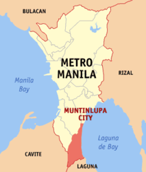
Muntinlupa is the southernmost administrative unit in the metropolitan area of Metro Manila and is located on the western shores of Laguna de Bay . Their neighboring communities are San Pedro , in the province of Laguna , in the south, Parañaque City and Taguig City, in the north, and Bacoor and Dasmariñas City , in the province of Cavite , in the west.
Barangays
The city of Muntinlupa is politically divided into 9 barangays .
District I.
- Alabang Riles
- Ayala Alabang
- Puli
- Cupang
- Sucat
District II
- Bayanan
- Poblacion
- Putatan
- Tunasan
Sons and daughters
- Reynaldo Getalado (* 1959), Catholic clergyman
Web links


