Naejangsan National Park
| Naejangsan ( 내장산 국립 공원 ) | ||
|---|---|---|
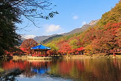
| Baekyangsa Temple Pavilion 백양사 | ||
|
|
||
| Location: | Jeollabuk-do , South Korea | |
| Next city: | Jeongeup ( 정읍시 ), Gochang ( 고창군 ), Gwangju ( 광주 광역시 ) | |
| Surface: | 81,715 km 2 | |
| Length: | 12 km | |
| Founding: | 17th November 1971 | |
The Naejangsan National Park ( Korean 내장산 국립 공원 ) is one of 22 National Park in South Korea . It was established in 1971 as the eighth national park in the south-west of the country.
Origin of name
The park originally got its name from the temple Yeongeunsan ( 영은 산 ), but was later renamed Naejangsan after the mountain of the same name , which is hidden in the word composition from “nae” ( 내 ) for in itself, “jang” ( 장 ) for and “san” ( 산 ) for mountain, which would mean something like “a mountain closed in on itself”.
geography
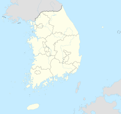
Naejangsan National Park is located around 8 km south-southeast of Jeongeup ( 정읍시 ) and east of Gochang County ( 고창군 ), partly in Jeollabuk-do ( 전라북도 ) and Jeollanam-do ( 전라남도 ) province . The national park is only 30 km north of Gwangju ( 광주 광역시 ), the city and administrative seat of Jeollanam-do province, and is therefore within reach of the metropolis of the southwest.
The national park has a size of 81.715 km 2 and comes in its southwest-northeast extension to 12 km. At its widest point, it measures 9.6 km. The mountain landscape of the park does not exceed a height of 763 m . The highest point in the park is the Naejangsan ( 내장산 ), which is considered to be the namesake of the national park. Other significant mountains in the park are the Baekamsan ( 백암산 ) with a height of 741 m , the Gainbong ( 가인 봉 ) with a height of 677 m and the Ibamsan ( 입 암산 ), which has a height of 626 m .
In the north of the park there is an approximately 1,100 m by 930 m reservoir, which is not used to generate electricity. Along with five other smaller lakes, it is the largest lake in the park. On the south side of the park is the 8.2 km long Jangseongho reservoir ( 장성호 ), which is no longer part of the park area.
history
The Naejangsan National Park was designated as a national park on November 17, 1971 and on August 5, 1987, the opening of the two offices North and South, through which the park should be administered. The two offices were renamed in 2006 and 2007 and are now called Naejangsan National Park Baekam Office .
Flora and fauna
There are 919 different plant species in the park, some of which are protected. Some particular trees are called Muscle Tree, Foreign Oak, Mongolian Oak, and Dog Forest. Furthermore, more than 1880 different animal species could be located, 12 of which are threatened with extinction.
Attractions
Two temples are located in the area of the Naejangsan National Park, the Baekyangsa Temple ( 백양사 ), which can be found on the mountain slope of Baekamsan in the south of the park, and the Naejangsa Temple ( 내장산 ), which is about 1.5 km northeast of the mountain Naejangsa is located in a valley.
literature
- 전국 안내 지도 . 우성 지도, Seoul 1999,ISBN 89-85762-10-9(National Guide Map).
Web links
- Introduction . Korea National Park Service,accessed November 27, 2017.
Individual evidence
- ↑ a b Introduction . Korea National Park Service , accessed November 27, 2017 .
- ↑ a b 전국 안내 지도 . 우성 지도 , Seoul 1999, ISBN 89-85762-10-9 , pp. 16, 19 ( National Guide Map ).
- ↑ a b Coordinates and longitudes were partly made using Google Earth Pro Version 7.3.0.3832 on November 27, 2017.
- ^ History . Korea National Park Service , accessed November 27, 2017 .
- ↑ Naejangsan National Park ( 내장산 국립 공원 ). In: Visit Korea . Korea Tourism Organization , accessed November 27, 2017 .

