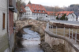
Nahe (lock)
| Near | ||
|
Close to Schleusingen |
||
| Data | ||
| Water code | DE : 41168 | |
| location | Thuringian Forest , Germany | |
| River system | Weser | |
| Drain over | Lock → Werra → Weser → North Sea | |
| source |
Upper near source on the southwest slope of the Great Finsterberg 50 ° 37 ′ 48 ″ N , 10 ° 47 ′ 38 ″ E |
|
| Source height | approx. 830 m above sea level NN | |
| muzzle | In the lock in Schleusingen Coordinates: 50 ° 30 ′ 4 ″ N , 10 ° 44 ′ 24 ″ E 50 ° 30 ′ 4 ″ N , 10 ° 44 ′ 24 ″ E |
|
| Mouth height | approx. 363 m above sea level NN | |
| Height difference | approx. 467 m | |
| Bottom slope | approx. 22 ‰ | |
| length | 21.5 km | |
| Catchment area | 123 km² | |
| Discharge at the Hinternah A Eo gauge : 35.3 km² Location: 5 km above the estuary |
NNQ (08/23/1959) MNQ 1947/2014 MQ 1947/2014 Mq 1947/2014 MHQ 1947/2014 HHQ (03/10/1981) |
10 l / s 139 l / s 866 l / s 24.5 l / (s km²) 9.4 m³ / s 25.4 m³ / s |
| Discharge at the Schleusingen A Eo gauge : 114 km² Location: 1 km above the mouth |
NNQ (11/09/1962) MNQ 1963/2010 MQ 1963/2010 Mq 1963/2010 MHQ 1963/2010 HHQ (03/11/1981) |
180 l / s 359 l / s 2.19 m³ / s 19.2 l / (s km²) 20.5 m³ / s 50 m³ / s |
| Left tributaries | Heimigbach (3.1 km), Bach vom Ziegensumpf (1.9 km), Breiter Bach (4.4 km), Fraubach (3.4 km), Querbach (2.8 km), Glasbach (2.2 km) | |
| Right tributaries | Silbach (3.7 km), Erle (14.2 km) | |
| Medium-sized cities | Suhl OT Schmiedefeld am Rennsteig | |
| Small towns | Schleusingen : eastern districts | |
| Communities | Vesser | |
| Residents in the catchment area | approx. 11,700 | |
The Nahe is a 21.5 km long river in the Thuringian Forest . It represents the second main river in the fan of the sluice and contributes about half of its water volume.
course
The Nahe rises in several source streams on the southern slope of the Großer Finsterberg ( 944 m ). The stream initially flows through the Suhler district Schmiedefeld am Rennsteig in a south-southeast direction and then continues in a narrow, wooded and from the steep flanks of the ridges of Hoher Buche (up to 748 m, west) and Schmiedswiesenkopf / Staudenkopf (up to 784 m, east) Lined Kerbsohlental to the south.
After a section on the outskirts of Schmiedefeld or the Ilmenau district of Frauenwald zu Vesser (city of Suhl) in the west, the river finally reaches the district of Hildburghausen with the Schleusingen district of Schleusingerneundorf , with the course of the river slowly turning towards the southwest.
Upon reaching the district of Hinternah , the Nahe leaves the actual Thuringian Forest and enters its red sandstone foreland. The valley widens into a meadow. In Schleusingen , by far the largest tributary alder flows into Schleusingen , which roughly doubles the amount of water in the Nahe, until the river finally flows into the lock from the left and in turn roughly doubles the amount of water.
Economic history
The Hohe Straße from Schleusingen to Erfurt , running through the Nahe valley, was one of the most important pass roads in the Middle Ages across the Thuringian Forest. The middle Nahe valley and its side valleys were only opened up very late, in the 16th century, by glassmakers and charcoal burners. The place Schmiedefeld was mentioned for the first time in 1414, here miners and subordinate trades had founded a rapidly growing settlement. In Schleusingerneundorf only about 190 inhabitants lived after 1600, who had to make a meager livelihood with forest work and alpine farming. Industrialization took place from Schleusingen - a glass factory was built in 1853.
Traffic development
The Rennsteigbahn railway line and Bundesstraße 4 run through the Nahe valley . The section from Schleusingen to Ilmenau with crossing the Rennsteig is one of the most scenic driving routes in the Thuringian Forest.
literature
- Horst H. Müller (Hrsg.): Travel guide Thuringian Forest and peripheral areas . Tourist Verlag, Berlin and Leipzig 1977, ISBN 3-350-00263-3 , p. 800 .
Individual evidence
- ↑ a b Map services of the Federal Agency for Nature Conservation ( information )
- ↑ a b c River lengths according to geopaths (kmz, 62 kB)
- ↑ Thuringian State Institute for the Environment (ed.): Area and water code index and map. Jena 1998; 26 pp.
- ^ German Hydrological Yearbook Weser-Ems 2014. Lower Saxony State Agency for Water Management, Coastal and Nature Conservation, p. 110, accessed on October 4, 2017 (PDF, German, 8805 kB).
- ↑ Level index of the Thuringia flood news center ( information )
- ↑ The discharge year 1963 began on November 1st, 1962, on November 9th, 1962 the minimum discharge was reached.
- ^ "Schleusingerneundorf" . In: Horst H. Müller (Hrsg.): Travel Guide Thuringian Forest and peripheral areas . Tourist Verlag, Berlin and Leipzig 1977, ISBN 3-350-00263-3 , p. 587-589 .
- ↑ Thuringian State Office for Building and Transport (Ed.) Strassenkarte Thuringia. 1: 200,000. Erfurt, April 2009 edition.
